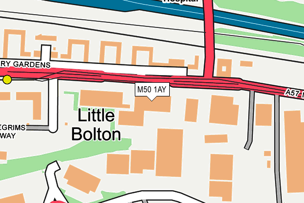
M50 1AY is located in the Weaste & Seedley electoral ward, within the metropolitan district of Salford and the English Parliamentary constituency of Salford and Eccles. The Sub Integrated Care Board (ICB) Location is NHS Greater Manchester ICB - 01G and the police force is Greater Manchester. This postcode has been in use since June 2002.


GetTheData
Source: OS OpenMap – Local (Ordnance Survey)
Source: OS VectorMap District (Ordnance Survey)
Licence: Open Government Licence (requires attribution)
| Easting | 378695 |
| Northing | 398591 |
| Latitude | 53.483601 |
| Longitude | -2.322520 |
GetTheData
Source: Open Postcode Geo
Licence: Open Government Licence
| Country | England |
| Postcode District | M50 |
➜ See where M50 is on a map ➜ Where is Salford? | |
GetTheData
Source: Land Registry Price Paid Data
Licence: Open Government Licence
Elevation or altitude of M50 1AY as distance above sea level:
| Metres | Feet | |
|---|---|---|
| Elevation | 30m | 98ft |
Elevation is measured from the approximate centre of the postcode, to the nearest point on an OS contour line from OS Terrain 50, which has contour spacing of ten vertical metres.
➜ How high above sea level am I? Find the elevation of your current position using your device's GPS.
GetTheData
Source: Open Postcode Elevation
Licence: Open Government Licence
| Ward | Weaste & Seedley |
| Constituency | Salford And Eccles |
GetTheData
Source: ONS Postcode Database
Licence: Open Government Licence
| Eccles New Rd/Stott Ln (Eccles New Rd) | Ladywell | 29m |
| Eccles New Rd/Stott Ln (Eccles New Rd) | Ladywell | 55m |
| Stott Ln/Eccles New Rd (Stott Ln) | Ladywell | 142m |
| Stott Ln/Eccles New Rd (Stott Ln) | Ladywell | 162m |
| Stott Ln/Salford Royal Hospital (Stott Ln) | Salford Royal Hospital | 387m |
| Ladywell (Manchester Metrolink) (Eccles New Road) | Ladywell | 400m |
| Eccles (Manchester Metrolink) (Regent Street) | Eccles | 845m |
| Weaste (Manchester Metrolink) (Eccles New Road) | Weaste | 971m |
| Eccles Station | 0.8km |
| Patricroft Station | 2.4km |
| Salford Crescent Station | 3.1km |
GetTheData
Source: NaPTAN
Licence: Open Government Licence
GetTheData
Source: ONS Postcode Database
Licence: Open Government Licence


➜ Get more ratings from the Food Standards Agency
GetTheData
Source: Food Standards Agency
Licence: FSA terms & conditions
| Last Collection | |||
|---|---|---|---|
| Location | Mon-Fri | Sat | Distance |
| Hope Hospital | 17:30 | 12:00 | 485m |
| Stott Lane / Eccles New Road | 17:30 | 11:45 | 617m |
| Gilda Brook P.o. | 17:30 | 12:00 | 621m |
GetTheData
Source: Dracos
Licence: Creative Commons Attribution-ShareAlike
The below table lists the International Territorial Level (ITL) codes (formerly Nomenclature of Territorial Units for Statistics (NUTS) codes) and Local Administrative Units (LAU) codes for M50 1AY:
| ITL 1 Code | Name |
|---|---|
| TLD | North West (England) |
| ITL 2 Code | Name |
| TLD3 | Greater Manchester |
| ITL 3 Code | Name |
| TLD34 | Greater Manchester South West |
| LAU 1 Code | Name |
| E08000006 | Salford |
GetTheData
Source: ONS Postcode Directory
Licence: Open Government Licence
The below table lists the Census Output Area (OA), Lower Layer Super Output Area (LSOA), and Middle Layer Super Output Area (MSOA) for M50 1AY:
| Code | Name | |
|---|---|---|
| OA | E00172971 | |
| LSOA | E01005720 | Salford 021D |
| MSOA | E02001177 | Salford 021 |
GetTheData
Source: ONS Postcode Directory
Licence: Open Government Licence
| M5 5AP | Eccles New Road | 84m |
| M5 5AJ | Canterbury Gardens | 108m |
| M5 5AL | Canterbury Gardens | 115m |
| M5 5AH | Canterbury Gardens | 141m |
| M50 1AZ | Pilgrims Way | 229m |
| M5 5AT | Canterbury Gardens | 241m |
| M5 5AE | Canterbury Gardens | 319m |
| M50 1AW | Pilgrims Way | 322m |
| M50 1AU | Pilgrims Way | 343m |
| M5 5AD | Canterbury Gardens | 381m |
GetTheData
Source: Open Postcode Geo; Land Registry Price Paid Data
Licence: Open Government Licence