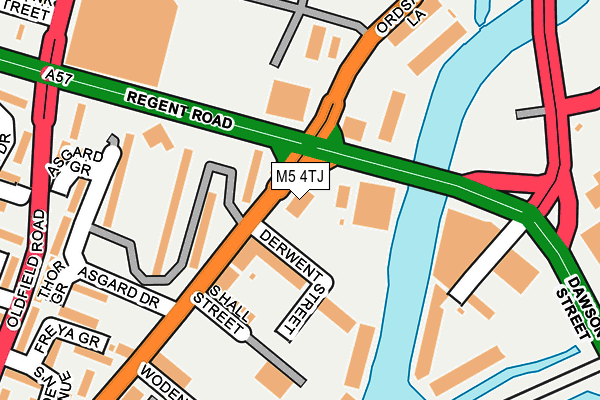
M5 4TJ is located in the Quays electoral ward, within the metropolitan district of Salford and the English Parliamentary constituency of Salford and Eccles. The Sub Integrated Care Board (ICB) Location is NHS Greater Manchester ICB - 01G and the police force is Greater Manchester. This postcode has been in use since March 2013.


GetTheData
Source: OS OpenMap – Local (Ordnance Survey)
Source: OS VectorMap District (Ordnance Survey)
Licence: Open Government Licence (requires attribution)
| Easting | 382491 |
| Northing | 397670 |
| Latitude | 53.475464 |
| Longitude | -2.265266 |
GetTheData
Source: Open Postcode Geo
Licence: Open Government Licence
| Country | England |
| Postcode District | M5 |
➜ See where M5 is on a map ➜ Where is Salford? | |
GetTheData
Source: Land Registry Price Paid Data
Licence: Open Government Licence
Elevation or altitude of M5 4TJ as distance above sea level:
| Metres | Feet | |
|---|---|---|
| Elevation | 30m | 98ft |
Elevation is measured from the approximate centre of the postcode, to the nearest point on an OS contour line from OS Terrain 50, which has contour spacing of ten vertical metres.
➜ How high above sea level am I? Find the elevation of your current position using your device's GPS.
GetTheData
Source: Open Postcode Elevation
Licence: Open Government Licence
| Ward | Quays |
| Constituency | Salford And Eccles |
GetTheData
Source: ONS Postcode Database
Licence: Open Government Licence
| Ordsall Ln/Regent Rd (Ordsall Ln) | Ordsall | 21m |
| Regent Rd/Ordsall Ln (Regent Rd) | Ordsall | 96m |
| Regent Rd/Regent Bridge (Regent Rd) | Castlefield | 137m |
| Regent Rd/Water St (Regent Rd) | Castlefield | 159m |
| Regent Rd/Sainsbury's (Regent Rd) | Ordsall | 222m |
| Cornbrook (Manchester Metrolink) | Cornbrook | 634m |
| Deansgate-castlefield (Manchester Metrolink) (Whitworth Street West) | Manchester City Centre | 930m |
| Salford Quays (Manchester Metrolink) (St Peters Quay) | Salford Quays | 1,372m |
| Anchorage (Manchester Metrolink) (Anchorage Quay) | Salford Quays | 1,387m |
| Pomona (Manchester Metrolink) (Pomona Strand) | Salford Quays | 1,439m |
| Deansgate Station | 1km |
| Salford Central Station | 1.1km |
| Salford Crescent Station | 1.4km |
GetTheData
Source: NaPTAN
Licence: Open Government Licence
GetTheData
Source: ONS Postcode Database
Licence: Open Government Licence


➜ Get more ratings from the Food Standards Agency
GetTheData
Source: Food Standards Agency
Licence: FSA terms & conditions
| Last Collection | |||
|---|---|---|---|
| Location | Mon-Fri | Sat | Distance |
| Water Street | 19:00 | 12:00 | 431m |
| Slate Wharf Castlefield | 17:30 | 12:00 | 527m |
| 18 Oldfield Road / Cow Lane | 17:30 | 11:45 | 532m |
GetTheData
Source: Dracos
Licence: Creative Commons Attribution-ShareAlike
The below table lists the International Territorial Level (ITL) codes (formerly Nomenclature of Territorial Units for Statistics (NUTS) codes) and Local Administrative Units (LAU) codes for M5 4TJ:
| ITL 1 Code | Name |
|---|---|
| TLD | North West (England) |
| ITL 2 Code | Name |
| TLD3 | Greater Manchester |
| ITL 3 Code | Name |
| TLD34 | Greater Manchester South West |
| LAU 1 Code | Name |
| E08000006 | Salford |
GetTheData
Source: ONS Postcode Directory
Licence: Open Government Licence
The below table lists the Census Output Area (OA), Lower Layer Super Output Area (LSOA), and Middle Layer Super Output Area (MSOA) for M5 4TJ:
| Code | Name | |
|---|---|---|
| OA | E00028700 | |
| LSOA | E01032917 | Salford 028J |
| MSOA | E02001184 | Salford 028 |
GetTheData
Source: ONS Postcode Directory
Licence: Open Government Licence
| M5 4TN | Asgard Drive | 55m |
| M5 4SS | Derwent Street | 66m |
| M5 4TW | Asgard Drive | 99m |
| M5 4SR | Derwent Street | 127m |
| M5 4TA | Lowry Wharf | 130m |
| M5 4TQ | Asgard Drive | 132m |
| M5 4SU | Lowry Wharf | 168m |
| M5 4SY | Lowry Wharf | 168m |
| M3 4JA | Water Street | 176m |
| M5 4TG | Asgard Drive | 183m |
GetTheData
Source: Open Postcode Geo; Land Registry Price Paid Data
Licence: Open Government Licence