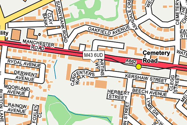
M43 6UD lies on Beard Street in Droylsden, Manchester. M43 6UD is located in the Droylsden East electoral ward, within the metropolitan district of Tameside and the English Parliamentary constituency of Ashton-under-Lyne. The Sub Integrated Care Board (ICB) Location is NHS Greater Manchester ICB - 01Y and the police force is Greater Manchester. This postcode has been in use since May 1994.


GetTheData
Source: OS OpenMap – Local (Ordnance Survey)
Source: OS VectorMap District (Ordnance Survey)
Licence: Open Government Licence (requires attribution)
| Easting | 389662 |
| Northing | 398152 |
| Latitude | 53.479987 |
| Longitude | -2.157241 |
GetTheData
Source: Open Postcode Geo
Licence: Open Government Licence
| Street | Beard Street |
| Locality | Droylsden |
| Town/City | Manchester |
| Country | England |
| Postcode District | M43 |
➜ See where M43 is on a map ➜ Where is Droylsden? | |
GetTheData
Source: Land Registry Price Paid Data
Licence: Open Government Licence
Elevation or altitude of M43 6UD as distance above sea level:
| Metres | Feet | |
|---|---|---|
| Elevation | 90m | 295ft |
Elevation is measured from the approximate centre of the postcode, to the nearest point on an OS contour line from OS Terrain 50, which has contour spacing of ten vertical metres.
➜ How high above sea level am I? Find the elevation of your current position using your device's GPS.
GetTheData
Source: Open Postcode Elevation
Licence: Open Government Licence
| Ward | Droylsden East |
| Constituency | Ashton-under-lyne |
GetTheData
Source: ONS Postcode Database
Licence: Open Government Licence
| Cemetery Road Tram Stop (Manchester Rd) | Droylsden | 140m |
| Cemetery Road Tram Stop (Manchester Rd) | Droylsden | 155m |
| Manchester Rd/Buxton Ln (Manchester Rd) | Droylsden | 216m |
| Manor Rd/Sunnybank Rd (Manor Rd) | Droylsden | 250m |
| Manor Rd/Lewis Rd (Manor Rd) | Droylsden | 272m |
| Cemetery Road (Manchester Metrolink) (Manchester Road) | Droylsden | 149m |
| Edge Lane (Manchester Metrolink) (Manchester Road) | Droylsden | 539m |
| Droylsden (Manchester Metrolink) (Ashton Road) | Droylsden | 836m |
| Fairfield Station | 1.2km |
| Gorton Station | 1.4km |
| Belle Vue Station | 2.5km |
GetTheData
Source: NaPTAN
Licence: Open Government Licence
| Percentage of properties with Next Generation Access | 100.0% |
| Percentage of properties with Superfast Broadband | 100.0% |
| Percentage of properties with Ultrafast Broadband | 0.0% |
| Percentage of properties with Full Fibre Broadband | 0.0% |
Superfast Broadband is between 30Mbps and 300Mbps
Ultrafast Broadband is > 300Mbps
| Percentage of properties unable to receive 2Mbps | 0.0% |
| Percentage of properties unable to receive 5Mbps | 0.0% |
| Percentage of properties unable to receive 10Mbps | 0.0% |
| Percentage of properties unable to receive 30Mbps | 0.0% |
GetTheData
Source: Ofcom
Licence: Ofcom Terms of Use (requires attribution)
GetTheData
Source: ONS Postcode Database
Licence: Open Government Licence


➜ Get more ratings from the Food Standards Agency
GetTheData
Source: Food Standards Agency
Licence: FSA terms & conditions
| Last Collection | |||
|---|---|---|---|
| Location | Mon-Fri | Sat | Distance |
| 120 Lumb Lane | 17:30 | 12:00 | 142m |
| Manor Road / Scott Road | 17:30 | 12:00 | 397m |
| 42 Wheeler Street | 17:30 | 12:00 | 798m |
GetTheData
Source: Dracos
Licence: Creative Commons Attribution-ShareAlike
The below table lists the International Territorial Level (ITL) codes (formerly Nomenclature of Territorial Units for Statistics (NUTS) codes) and Local Administrative Units (LAU) codes for M43 6UD:
| ITL 1 Code | Name |
|---|---|
| TLD | North West (England) |
| ITL 2 Code | Name |
| TLD3 | Greater Manchester |
| ITL 3 Code | Name |
| TLD35 | Greater Manchester South East |
| LAU 1 Code | Name |
| E08000008 | Tameside |
GetTheData
Source: ONS Postcode Directory
Licence: Open Government Licence
The below table lists the Census Output Area (OA), Lower Layer Super Output Area (LSOA), and Middle Layer Super Output Area (MSOA) for M43 6UD:
| Code | Name | |
|---|---|---|
| OA | E00030382 | |
| LSOA | E01005998 | Tameside 012A |
| MSOA | E02001240 | Tameside 012 |
GetTheData
Source: ONS Postcode Directory
Licence: Open Government Licence
| M43 6HE | Manchester Road | 13m |
| M43 6LZ | Carpenters Walk | 47m |
| M43 6PQ | Oakfield Avenue | 91m |
| M43 6FZ | Kershaw Street | 110m |
| M43 6PG | Oakfield Avenue | 121m |
| M43 6HF | Manchester Road | 126m |
| M43 6HB | Herbert Street | 132m |
| M43 6PJ | Sunnybank Road | 143m |
| M43 6GD | Manchester Road | 162m |
| M43 6HA | Brook Avenue | 163m |
GetTheData
Source: Open Postcode Geo; Land Registry Price Paid Data
Licence: Open Government Licence