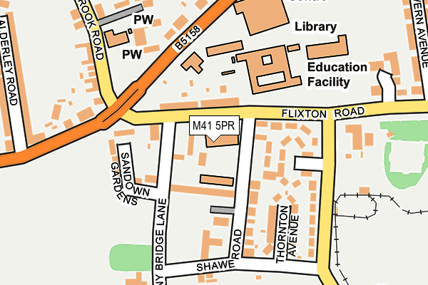
M41 5PR lies on Flixton Road in Urmston, Manchester. M41 5PR is located in the Flixton electoral ward, within the metropolitan district of Trafford and the English Parliamentary constituency of Stretford and Urmston. The Sub Integrated Care Board (ICB) Location is NHS Greater Manchester ICB - 02A and the police force is Greater Manchester. This postcode has been in use since December 1996.


GetTheData
Source: OS OpenMap – Local (Ordnance Survey)
Source: OS VectorMap District (Ordnance Survey)
Licence: Open Government Licence (requires attribution)
| Easting | 375380 |
| Northing | 394706 |
| Latitude | 53.448536 |
| Longitude | -2.372168 |
GetTheData
Source: Open Postcode Geo
Licence: Open Government Licence
| Street | Flixton Road |
| Locality | Urmston |
| Town/City | Manchester |
| Country | England |
| Postcode District | M41 |
➜ See where M41 is on a map ➜ Where is Urmston? | |
GetTheData
Source: Land Registry Price Paid Data
Licence: Open Government Licence
Elevation or altitude of M41 5PR as distance above sea level:
| Metres | Feet | |
|---|---|---|
| Elevation | 20m | 66ft |
Elevation is measured from the approximate centre of the postcode, to the nearest point on an OS contour line from OS Terrain 50, which has contour spacing of ten vertical metres.
➜ How high above sea level am I? Find the elevation of your current position using your device's GPS.
GetTheData
Source: Open Postcode Elevation
Licence: Open Government Licence
| Ward | Flixton |
| Constituency | Stretford And Urmston |
GetTheData
Source: ONS Postcode Database
Licence: Open Government Licence
211, FLIXTON ROAD, URMSTON, MANCHESTER, M41 5PR 2004 24 JUN £475,000 |
GetTheData
Source: HM Land Registry Price Paid Data
Licence: Contains HM Land Registry data © Crown copyright and database right 2025. This data is licensed under the Open Government Licence v3.0.
| Flixton Road/Girls High School (Flixton Road) | Flixton | 42m |
| Flixton Road/Girls High School (Flixton Road) | Flixton | 94m |
| Bowfell Road/Urmston Leisure Centre (Bowfell Road) | Flixton | 130m |
| Bowfell Road/Urmston Leisure Centre (Bowfell Road) | Flixton | 140m |
| Brook Rd (Nbd) (Brook Road) | Flixton | 159m |
| Chassen Road Station | 0.4km |
| Flixton Station | 1km |
| Urmston Station | 1.2km |
GetTheData
Source: NaPTAN
Licence: Open Government Licence
GetTheData
Source: ONS Postcode Database
Licence: Open Government Licence


➜ Get more ratings from the Food Standards Agency
GetTheData
Source: Food Standards Agency
Licence: FSA terms & conditions
| Last Collection | |||
|---|---|---|---|
| Location | Mon-Fri | Sat | Distance |
| Flixton Road | 17:30 | 11:30 | 118m |
| 169 Moorside Road | 17:30 | 12:00 | 435m |
| Whitelake Avenue | 17:30 | 11:30 | 459m |
GetTheData
Source: Dracos
Licence: Creative Commons Attribution-ShareAlike
The below table lists the International Territorial Level (ITL) codes (formerly Nomenclature of Territorial Units for Statistics (NUTS) codes) and Local Administrative Units (LAU) codes for M41 5PR:
| ITL 1 Code | Name |
|---|---|
| TLD | North West (England) |
| ITL 2 Code | Name |
| TLD3 | Greater Manchester |
| ITL 3 Code | Name |
| TLD34 | Greater Manchester South West |
| LAU 1 Code | Name |
| E08000009 | Trafford |
GetTheData
Source: ONS Postcode Directory
Licence: Open Government Licence
The below table lists the Census Output Area (OA), Lower Layer Super Output Area (LSOA), and Middle Layer Super Output Area (MSOA) for M41 5PR:
| Code | Name | |
|---|---|---|
| OA | E00031044 | |
| LSOA | E01006129 | Trafford 010B |
| MSOA | E02001268 | Trafford 010 |
GetTheData
Source: ONS Postcode Directory
Licence: Open Government Licence
| M41 5DZ | Acregate | 31m |
| M41 5DN | Flixton Road | 67m |
| M41 5DU | Shawe View | 68m |
| M41 5DY | Flixton Road | 73m |
| M41 5DL | Shawe Road | 96m |
| M41 5DS | Chassen Avenue | 96m |
| M41 5EZ | Sandown Gardens | 141m |
| M41 5DR | Flixton Road | 146m |
| M41 5DJ | Thornton Avenue | 159m |
| M41 5SR | The Spinney | 180m |
GetTheData
Source: Open Postcode Geo; Land Registry Price Paid Data
Licence: Open Government Licence