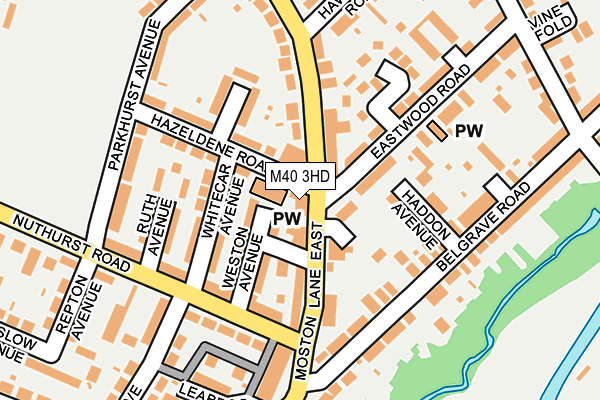
M40 3HD is located in the Moston electoral ward, within the metropolitan district of Manchester and the English Parliamentary constituency of Manchester Central. The Sub Integrated Care Board (ICB) Location is NHS Greater Manchester ICB - 14L and the police force is Greater Manchester. This postcode has been in use since June 1997.


GetTheData
Source: OS OpenMap – Local (Ordnance Survey)
Source: OS VectorMap District (Ordnance Survey)
Licence: Open Government Licence (requires attribution)
| Easting | 389397 |
| Northing | 402180 |
| Latitude | 53.516187 |
| Longitude | -2.161372 |
GetTheData
Source: Open Postcode Geo
Licence: Open Government Licence
| Country | England |
| Postcode District | M40 |
➜ See where M40 is on a map ➜ Where is Manchester? | |
GetTheData
Source: Land Registry Price Paid Data
Licence: Open Government Licence
Elevation or altitude of M40 3HD as distance above sea level:
| Metres | Feet | |
|---|---|---|
| Elevation | 100m | 328ft |
Elevation is measured from the approximate centre of the postcode, to the nearest point on an OS contour line from OS Terrain 50, which has contour spacing of ten vertical metres.
➜ How high above sea level am I? Find the elevation of your current position using your device's GPS.
GetTheData
Source: Open Postcode Elevation
Licence: Open Government Licence
| Ward | Moston |
| Constituency | Manchester Central |
GetTheData
Source: ONS Postcode Database
Licence: Open Government Licence
| Moston Lane East (Moston La East) | New Moston | 16m |
| Moston Ln East/Hazeldene Rd (Moston Ln East) | New Moston | 38m |
| Moston Ln East/New Moston Shops (Moston Ln East) | New Moston | 65m |
| Moston Ln East/Hawthorn Rd (Moston Ln East) | New Moston | 104m |
| Hazeldene Road (Hazeldene Rd) | New Moston | 175m |
| Failsworth (Manchester Metrolink) (Hardman Lane) | Failsworth | 630m |
| Hollinwood (Manchester Metrolink) (Railway Road) | Hollinwood | 1,005m |
| South Chadderton (Manchester Metrolink) (Canal St) | White Gate | 1,567m |
| Moston Station | 1km |
| Mills Hill (Manchester) Station | 4km |
| Fairfield Station | 5.1km |
GetTheData
Source: NaPTAN
Licence: Open Government Licence
GetTheData
Source: ONS Postcode Database
Licence: Open Government Licence


➜ Get more ratings from the Food Standards Agency
GetTheData
Source: Food Standards Agency
Licence: FSA terms & conditions
| Last Collection | |||
|---|---|---|---|
| Location | Mon-Fri | Sat | Distance |
| Morrisons | 17:40 | 12:00 | 743m |
| Delmahoy Close | 17:30 | 12:00 | 1,056m |
| Horncastle Road | 17:30 | 12:00 | 1,635m |
GetTheData
Source: Dracos
Licence: Creative Commons Attribution-ShareAlike
The below table lists the International Territorial Level (ITL) codes (formerly Nomenclature of Territorial Units for Statistics (NUTS) codes) and Local Administrative Units (LAU) codes for M40 3HD:
| ITL 1 Code | Name |
|---|---|
| TLD | North West (England) |
| ITL 2 Code | Name |
| TLD3 | Greater Manchester |
| ITL 3 Code | Name |
| TLD33 | Manchester |
| LAU 1 Code | Name |
| E08000003 | Manchester |
GetTheData
Source: ONS Postcode Directory
Licence: Open Government Licence
The below table lists the Census Output Area (OA), Lower Layer Super Output Area (LSOA), and Middle Layer Super Output Area (MSOA) for M40 3HD:
| Code | Name | |
|---|---|---|
| OA | E00026605 | |
| LSOA | E01005247 | Manchester 005A |
| MSOA | E02001049 | Manchester 005 |
GetTheData
Source: ONS Postcode Directory
Licence: Open Government Licence
| M40 3QU | Westwood Avenue | 72m |
| M40 3QP | Weston Avenue | 77m |
| M40 3GP | Moston Lane East | 78m |
| M40 3GW | Whitecar Avenue | 84m |
| M40 3QL | Moston Lane East | 93m |
| M40 3SB | Haddon Avenue | 106m |
| M40 3GE | Menston Avenue | 108m |
| M40 3PU | Nuthurst Road | 113m |
| M40 3QY | Moston Lane East | 113m |
| M40 3SD | Culross Avenue | 116m |
GetTheData
Source: Open Postcode Geo; Land Registry Price Paid Data
Licence: Open Government Licence