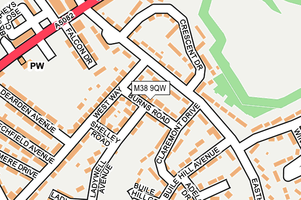
M38 9QW lies on Burns Road in Little Hulton, Manchester. M38 9QW is located in the Walkden North electoral ward, within the metropolitan district of Salford and the English Parliamentary constituency of Worsley and Eccles South. The Sub Integrated Care Board (ICB) Location is NHS Greater Manchester ICB - 01G and the police force is Greater Manchester. This postcode has been in use since May 1994.


GetTheData
Source: OS OpenMap – Local (Ordnance Survey)
Source: OS VectorMap District (Ordnance Survey)
Licence: Open Government Licence (requires attribution)
| Easting | 372581 |
| Northing | 404226 |
| Latitude | 53.533965 |
| Longitude | -2.415147 |
GetTheData
Source: Open Postcode Geo
Licence: Open Government Licence
| Street | Burns Road |
| Locality | Little Hulton |
| Town/City | Manchester |
| Country | England |
| Postcode District | M38 |
➜ See where M38 is on a map ➜ Where is Little Hulton? | |
GetTheData
Source: Land Registry Price Paid Data
Licence: Open Government Licence
Elevation or altitude of M38 9QW as distance above sea level:
| Metres | Feet | |
|---|---|---|
| Elevation | 110m | 361ft |
Elevation is measured from the approximate centre of the postcode, to the nearest point on an OS contour line from OS Terrain 50, which has contour spacing of ten vertical metres.
➜ How high above sea level am I? Find the elevation of your current position using your device's GPS.
GetTheData
Source: Open Postcode Elevation
Licence: Open Government Licence
| Ward | Walkden North |
| Constituency | Worsley And Eccles South |
GetTheData
Source: ONS Postcode Database
Licence: Open Government Licence
| Eastham Way/Claremont Dr (Eastham Way) | Little Hulton | 87m |
| Eastham Way/Crescent Dr (Eastham Way) | Little Hulton | 128m |
| Eastham Way/Buile Hill Ave (Eastham Way) | Little Hulton | 136m |
| Eastham Way/Cleggs Ln (Eastham Way) | Little Hulton | 142m |
| Eastham Way/Trafford Dr (Eastham Way) | Little Hulton | 237m |
| Walkden Station | 2km |
| Farnworth Station | 2.5km |
| Moses Gate Station | 2.6km |
GetTheData
Source: NaPTAN
Licence: Open Government Licence
| Percentage of properties with Next Generation Access | 100.0% |
| Percentage of properties with Superfast Broadband | 100.0% |
| Percentage of properties with Ultrafast Broadband | 100.0% |
| Percentage of properties with Full Fibre Broadband | 100.0% |
Superfast Broadband is between 30Mbps and 300Mbps
Ultrafast Broadband is > 300Mbps
| Median download speed | 40.0Mbps |
| Average download speed | 87.7Mbps |
| Maximum download speed | 200.00Mbps |
| Median upload speed | 1.2Mbps |
| Average upload speed | 4.7Mbps |
| Maximum upload speed | 10.00Mbps |
| Percentage of properties unable to receive 2Mbps | 0.0% |
| Percentage of properties unable to receive 5Mbps | 0.0% |
| Percentage of properties unable to receive 10Mbps | 0.0% |
| Percentage of properties unable to receive 30Mbps | 0.0% |
GetTheData
Source: Ofcom
Licence: Ofcom Terms of Use (requires attribution)
Estimated total energy consumption in M38 9QW by fuel type, 2015.
| Consumption (kWh) | 239,632 |
|---|---|
| Meter count | 24 |
| Mean (kWh/meter) | 9,985 |
| Median (kWh/meter) | 10,211 |
| Consumption (kWh) | 82,559 |
|---|---|
| Meter count | 21 |
| Mean (kWh/meter) | 3,931 |
| Median (kWh/meter) | 3,362 |
GetTheData
Source: Postcode level gas estimates: 2015 (experimental)
Source: Postcode level electricity estimates: 2015 (experimental)
Licence: Open Government Licence
GetTheData
Source: ONS Postcode Database
Licence: Open Government Licence


➜ Get more ratings from the Food Standards Agency
GetTheData
Source: Food Standards Agency
Licence: FSA terms & conditions
| Last Collection | |||
|---|---|---|---|
| Location | Mon-Fri | Sat | Distance |
| Eastham Way | 17:30 | 12:00 | 184m |
| 1 Old Lane/Cleggs Lane | 17:30 | 12:00 | 459m |
| Tesco | 17:00 | 12:00 | 1,223m |
GetTheData
Source: Dracos
Licence: Creative Commons Attribution-ShareAlike
The below table lists the International Territorial Level (ITL) codes (formerly Nomenclature of Territorial Units for Statistics (NUTS) codes) and Local Administrative Units (LAU) codes for M38 9QW:
| ITL 1 Code | Name |
|---|---|
| TLD | North West (England) |
| ITL 2 Code | Name |
| TLD3 | Greater Manchester |
| ITL 3 Code | Name |
| TLD34 | Greater Manchester South West |
| LAU 1 Code | Name |
| E08000006 | Salford |
GetTheData
Source: ONS Postcode Directory
Licence: Open Government Licence
The below table lists the Census Output Area (OA), Lower Layer Super Output Area (LSOA), and Middle Layer Super Output Area (MSOA) for M38 9QW:
| Code | Name | |
|---|---|---|
| OA | E00028891 | |
| LSOA | E01005704 | Salford 002B |
| MSOA | E02001158 | Salford 002 |
GetTheData
Source: ONS Postcode Directory
Licence: Open Government Licence
| M38 9QF | Eastham Way | 56m |
| M38 9PT | Wordsworth Road | 62m |
| M38 9QE | Eastham Way | 77m |
| M38 9QN | West Way | 92m |
| M38 9PX | Shelley Road | 98m |
| M38 9QH | Crescent Drive | 117m |
| M38 9GP | Buile Hill Avenue | 145m |
| M38 9SN | Falcon Drive | 157m |
| M38 9GF | Crescent Drive | 174m |
| M38 9GT | Buile Hill Grove | 176m |
GetTheData
Source: Open Postcode Geo; Land Registry Price Paid Data
Licence: Open Government Licence