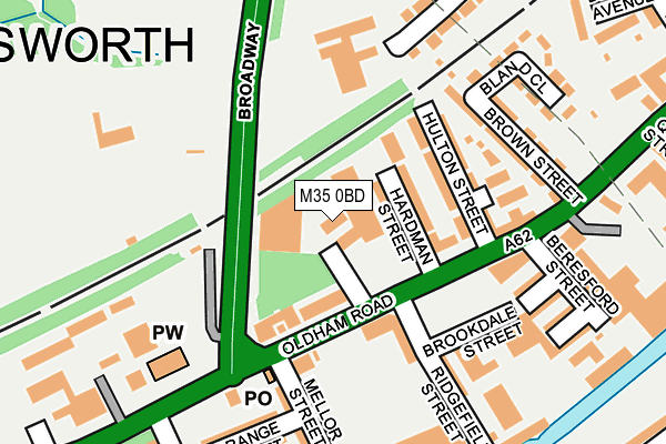
M35 0BD is located in the Failsworth West electoral ward, within the metropolitan district of Oldham and the English Parliamentary constituency of Ashton-under-Lyne. The Sub Integrated Care Board (ICB) Location is NHS Greater Manchester ICB - 00Y and the police force is Greater Manchester. This postcode has been in use since January 1980.


GetTheData
Source: OS OpenMap – Local (Ordnance Survey)
Source: OS VectorMap District (Ordnance Survey)
Licence: Open Government Licence (requires attribution)
| Easting | 388894 |
| Northing | 401162 |
| Latitude | 53.507027 |
| Longitude | -2.168921 |
GetTheData
Source: Open Postcode Geo
Licence: Open Government Licence
| Country | England |
| Postcode District | M35 |
➜ See where M35 is on a map ➜ Where is Failsworth? | |
GetTheData
Source: Land Registry Price Paid Data
Licence: Open Government Licence
Elevation or altitude of M35 0BD as distance above sea level:
| Metres | Feet | |
|---|---|---|
| Elevation | 90m | 295ft |
Elevation is measured from the approximate centre of the postcode, to the nearest point on an OS contour line from OS Terrain 50, which has contour spacing of ten vertical metres.
➜ How high above sea level am I? Find the elevation of your current position using your device's GPS.
GetTheData
Source: Open Postcode Elevation
Licence: Open Government Licence
| Ward | Failsworth West |
| Constituency | Ashton-under-lyne |
GetTheData
Source: ONS Postcode Database
Licence: Open Government Licence
| Oldham Rd/Ridgefield St (Oldham Rd) | Failsworth | 82m |
| Oldham Rd/Ridgefield St (Oldham Rd) | Failsworth | 90m |
| Oldham Rd/Brown St (Oldham Rd) | Failsworth | 222m |
| Oldham Rd/Broadway (Oldham Rd) | Failsworth | 238m |
| Oldham Rd/Ashton Rd West (Oldham Rd) | Failsworth | 287m |
| Failsworth (Manchester Metrolink) (Hardman Lane) | Failsworth | 562m |
| Newton Heath & Moston (Manchester Metrolink) (Dean Lane) | Newton Heath | 1,093m |
| Hollinwood (Manchester Metrolink) (Railway Road) | Hollinwood | 2,012m |
| Moston Station | 1.8km |
| Gorton Station | 4.2km |
| Fairfield Station | 4.3km |
GetTheData
Source: NaPTAN
Licence: Open Government Licence
GetTheData
Source: ONS Postcode Database
Licence: Open Government Licence


➜ Get more ratings from the Food Standards Agency
GetTheData
Source: Food Standards Agency
Licence: FSA terms & conditions
| Last Collection | |||
|---|---|---|---|
| Location | Mon-Fri | Sat | Distance |
| Delmahoy Close | 17:30 | 12:00 | 716m |
| New Moston | 17:30 | 12:00 | 1,595m |
| Horncastle Road | 17:30 | 12:00 | 1,675m |
GetTheData
Source: Dracos
Licence: Creative Commons Attribution-ShareAlike
The below table lists the International Territorial Level (ITL) codes (formerly Nomenclature of Territorial Units for Statistics (NUTS) codes) and Local Administrative Units (LAU) codes for M35 0BD:
| ITL 1 Code | Name |
|---|---|
| TLD | North West (England) |
| ITL 2 Code | Name |
| TLD3 | Greater Manchester |
| ITL 3 Code | Name |
| TLD37 | Greater Manchester North East |
| LAU 1 Code | Name |
| E08000004 | Oldham |
GetTheData
Source: ONS Postcode Directory
Licence: Open Government Licence
The below table lists the Census Output Area (OA), Lower Layer Super Output Area (LSOA), and Middle Layer Super Output Area (MSOA) for M35 0BD:
| Code | Name | |
|---|---|---|
| OA | E00027188 | |
| LSOA | E01005369 | Oldham 032B |
| MSOA | E02001129 | Oldham 032 |
GetTheData
Source: ONS Postcode Directory
Licence: Open Government Licence
| M35 0DB | Broadway | 48m |
| M35 0BB | Hardman Street | 78m |
| M35 0AZ | Hulton Street | 128m |
| M35 0HP | Oldham Road | 139m |
| M35 0AY | Oldham Road | 143m |
| M35 0AX | Brown Street | 164m |
| M35 0HH | Oldham Road | 168m |
| M35 0HT | Mellor Street | 177m |
| M35 0HJ | Ridgefield Street | 185m |
| M35 0HF | Brookdale Street | 197m |
GetTheData
Source: Open Postcode Geo; Land Registry Price Paid Data
Licence: Open Government Licence