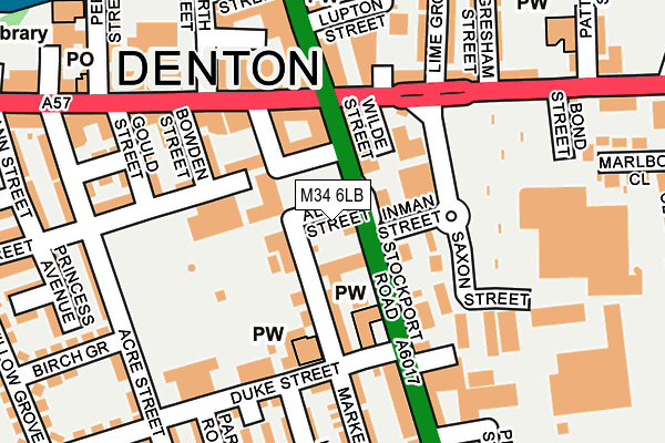
M34 6LB lies on Albert Street in Denton, Manchester. M34 6LB is located in the Denton North East electoral ward, within the metropolitan district of Tameside and the English Parliamentary constituency of Denton and Reddish. The Sub Integrated Care Board (ICB) Location is NHS Greater Manchester ICB - 01Y and the police force is Greater Manchester. This postcode has been in use since May 1994.


GetTheData
Source: OS OpenMap – Local (Ordnance Survey)
Source: OS VectorMap District (Ordnance Survey)
Licence: Open Government Licence (requires attribution)
| Easting | 392548 |
| Northing | 395387 |
| Latitude | 53.455200 |
| Longitude | -2.113688 |
GetTheData
Source: Open Postcode Geo
Licence: Open Government Licence
| Street | Albert Street |
| Locality | Denton |
| Town/City | Manchester |
| Country | England |
| Postcode District | M34 |
➜ See where M34 is on a map ➜ Where is Denton? | |
GetTheData
Source: Land Registry Price Paid Data
Licence: Open Government Licence
Elevation or altitude of M34 6LB as distance above sea level:
| Metres | Feet | |
|---|---|---|
| Elevation | 100m | 328ft |
Elevation is measured from the approximate centre of the postcode, to the nearest point on an OS contour line from OS Terrain 50, which has contour spacing of ten vertical metres.
➜ How high above sea level am I? Find the elevation of your current position using your device's GPS.
GetTheData
Source: Open Postcode Elevation
Licence: Open Government Licence
| Ward | Denton North East |
| Constituency | Denton And Reddish |
GetTheData
Source: ONS Postcode Database
Licence: Open Government Licence
| Stockport Rd/Crown Point (Stockport Rd) | Denton | 37m |
| Stockport Rd/Crown Point (Stockport Rd) | Denton | 40m |
| Saxon St/Morrisons (Saxon St) | Denton | 116m |
| Hyde Rd/Nelson St (Hyde Rd) | Denton | 133m |
| Stockport Rd/Police Stn (Stockport Rd) | Denton | 175m |
| Denton Station | 1.2km |
| Hyde Central Station | 1.9km |
| Hyde North Station | 2.2km |
GetTheData
Source: NaPTAN
Licence: Open Government Licence
GetTheData
Source: ONS Postcode Database
Licence: Open Government Licence


➜ Get more ratings from the Food Standards Agency
GetTheData
Source: Food Standards Agency
Licence: FSA terms & conditions
| Last Collection | |||
|---|---|---|---|
| Location | Mon-Fri | Sat | Distance |
| Cardinal Street | 17:30 | 11:45 | 993m |
| 289 Manchester Road | 17:30 | 12:00 | 1,516m |
| Stamford Road | 17:30 | 12:00 | 1,557m |
GetTheData
Source: Dracos
Licence: Creative Commons Attribution-ShareAlike
The below table lists the International Territorial Level (ITL) codes (formerly Nomenclature of Territorial Units for Statistics (NUTS) codes) and Local Administrative Units (LAU) codes for M34 6LB:
| ITL 1 Code | Name |
|---|---|
| TLD | North West (England) |
| ITL 2 Code | Name |
| TLD3 | Greater Manchester |
| ITL 3 Code | Name |
| TLD35 | Greater Manchester South East |
| LAU 1 Code | Name |
| E08000008 | Tameside |
GetTheData
Source: ONS Postcode Directory
Licence: Open Government Licence
The below table lists the Census Output Area (OA), Lower Layer Super Output Area (LSOA), and Middle Layer Super Output Area (MSOA) for M34 6LB:
| Code | Name | |
|---|---|---|
| OA | E00030275 | |
| LSOA | E01005974 | Tameside 021C |
| MSOA | E02001249 | Tameside 021 |
GetTheData
Source: ONS Postcode Directory
Licence: Open Government Licence
| M34 6AB | Stockport Road | 18m |
| M34 6ZA | Albert Street | 22m |
| M34 2XW | Market Street | 67m |
| M34 3JQ | Victoria Street | 70m |
| M34 2JL | Market Street | 80m |
| M34 2FH | Market Street | 85m |
| M34 6DA | Stockport Road | 92m |
| M34 2AB | Bowden Street | 128m |
| M34 2AA | Victoria Street | 145m |
| M34 3AF | Hyde Road | 156m |
GetTheData
Source: Open Postcode Geo; Land Registry Price Paid Data
Licence: Open Government Licence