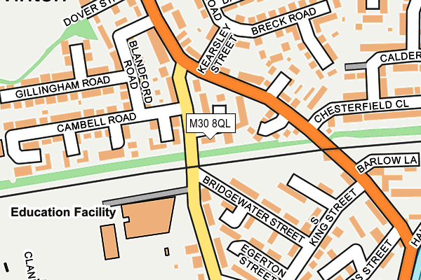
M30 8QL is located in the Barton & Winton electoral ward, within the metropolitan district of Salford and the English Parliamentary constituency of Worsley and Eccles South. The Sub Integrated Care Board (ICB) Location is NHS Greater Manchester ICB - 01G and the police force is Greater Manchester. This postcode has been in use since January 1980.


GetTheData
Source: OS OpenMap – Local (Ordnance Survey)
Source: OS VectorMap District (Ordnance Survey)
Licence: Open Government Licence (requires attribution)
| Easting | 375846 |
| Northing | 398717 |
| Latitude | 53.484626 |
| Longitude | -2.365460 |
GetTheData
Source: Open Postcode Geo
Licence: Open Government Licence
| Country | England |
| Postcode District | M30 |
➜ See where M30 is on a map ➜ Where is Eccles? | |
GetTheData
Source: Land Registry Price Paid Data
Licence: Open Government Licence
Elevation or altitude of M30 8QL as distance above sea level:
| Metres | Feet | |
|---|---|---|
| Elevation | 20m | 66ft |
Elevation is measured from the approximate centre of the postcode, to the nearest point on an OS contour line from OS Terrain 50, which has contour spacing of ten vertical metres.
➜ How high above sea level am I? Find the elevation of your current position using your device's GPS.
GetTheData
Source: Open Postcode Elevation
Licence: Open Government Licence
| Ward | Barton & Winton |
| Constituency | Worsley And Eccles South |
GetTheData
Source: ONS Postcode Database
Licence: Open Government Licence
| New Ln/Midford Ave (New Ln) | Winton | 40m |
| New Ln/Cambell Rd (New Ln) | Winton | 52m |
| New Ln/Bridgewater St (New Ln) | Winton | 55m |
| Bridgewater St (Ebd) (Bridgewater St) | Winton | 61m |
| Worsley Rd/Pollitts Cl (Worsley R) | Winton | 83m |
| Patricroft Station | 0.5km |
| Eccles Station | 2.1km |
| Moorside Station | 3.6km |
GetTheData
Source: NaPTAN
Licence: Open Government Licence
| Percentage of properties with Next Generation Access | 100.0% |
| Percentage of properties with Superfast Broadband | 100.0% |
| Percentage of properties with Ultrafast Broadband | 100.0% |
| Percentage of properties with Full Fibre Broadband | 100.0% |
Superfast Broadband is between 30Mbps and 300Mbps
Ultrafast Broadband is > 300Mbps
| Percentage of properties unable to receive 2Mbps | 0.0% |
| Percentage of properties unable to receive 5Mbps | 0.0% |
| Percentage of properties unable to receive 10Mbps | 0.0% |
| Percentage of properties unable to receive 30Mbps | 0.0% |
GetTheData
Source: Ofcom
Licence: Ofcom Terms of Use (requires attribution)
GetTheData
Source: ONS Postcode Database
Licence: Open Government Licence


➜ Get more ratings from the Food Standards Agency
GetTheData
Source: Food Standards Agency
Licence: FSA terms & conditions
| Last Collection | |||
|---|---|---|---|
| Location | Mon-Fri | Sat | Distance |
| Winton P.o. | 17:30 | 12:00 | 152m |
| Montonfields | 17:30 | 12:00 | 496m |
| Westwood Park P.o. | 17:30 | 12:00 | 913m |
GetTheData
Source: Dracos
Licence: Creative Commons Attribution-ShareAlike
The below table lists the International Territorial Level (ITL) codes (formerly Nomenclature of Territorial Units for Statistics (NUTS) codes) and Local Administrative Units (LAU) codes for M30 8QL:
| ITL 1 Code | Name |
|---|---|
| TLD | North West (England) |
| ITL 2 Code | Name |
| TLD3 | Greater Manchester |
| ITL 3 Code | Name |
| TLD34 | Greater Manchester South West |
| LAU 1 Code | Name |
| E08000006 | Salford |
GetTheData
Source: ONS Postcode Directory
Licence: Open Government Licence
The below table lists the Census Output Area (OA), Lower Layer Super Output Area (LSOA), and Middle Layer Super Output Area (MSOA) for M30 8QL:
| Code | Name | |
|---|---|---|
| OA | E00029021 | |
| LSOA | E01005729 | Salford 025A |
| MSOA | E02001181 | Salford 025 |
GetTheData
Source: ONS Postcode Directory
Licence: Open Government Licence
| M30 8NG | Annisdale Close | 50m |
| M30 8SL | Signal Close | 87m |
| M30 8PL | New Lane | 88m |
| M30 8LS | Worsley Road | 115m |
| M30 8LQ | Brodie Close | 128m |
| M30 8WA | Blandford Road | 139m |
| M30 7JL | New Lane | 142m |
| M30 8WG | Selsby Avenue | 148m |
| M30 8LN | Pollitts Close | 154m |
| M30 8NU | Kearsley Street | 156m |
GetTheData
Source: Open Postcode Geo; Land Registry Price Paid Data
Licence: Open Government Licence