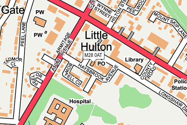
M28 0AT is located in the Little Hulton electoral ward, within the metropolitan district of Salford and the English Parliamentary constituency of Worsley and Eccles South. The Sub Integrated Care Board (ICB) Location is NHS Greater Manchester ICB - 01G and the police force is Greater Manchester. This postcode has been in use since December 1995.


GetTheData
Source: OS OpenMap – Local (Ordnance Survey)
Source: OS VectorMap District (Ordnance Survey)
Licence: Open Government Licence (requires attribution)
| Easting | 372033 |
| Northing | 403761 |
| Latitude | 53.529757 |
| Longitude | -2.423373 |
GetTheData
Source: Open Postcode Geo
Licence: Open Government Licence
| Country | England |
| Postcode District | M28 |
➜ See where M28 is on a map ➜ Where is Little Hulton? | |
GetTheData
Source: Land Registry Price Paid Data
Licence: Open Government Licence
Elevation or altitude of M28 0AT as distance above sea level:
| Metres | Feet | |
|---|---|---|
| Elevation | 100m | 328ft |
Elevation is measured from the approximate centre of the postcode, to the nearest point on an OS contour line from OS Terrain 50, which has contour spacing of ten vertical metres.
➜ How high above sea level am I? Find the elevation of your current position using your device's GPS.
GetTheData
Source: Open Postcode Elevation
Licence: Open Government Licence
| Ward | Little Hulton |
| Constituency | Worsley And Eccles South |
GetTheData
Source: ONS Postcode Database
Licence: Open Government Licence
| Haysbrook Ave/Health Ctr (Haysbrook Ave) | Little Hulton | 46m |
| Haysbrook Ave/Health Ctr (Haysbrook Ave) | Little Hulton | 52m |
| Mcr Rd E/Little Hulton Precinct (M/Cr Rd East) | Little Hulton | 105m |
| Armitage Ave/Haysbrook Ave (Armitage Ave) | Little Hulton | 108m |
| Armitage Ave/Armitage Gr (Armitage Ave) | Little Hulton | 133m |
| Walkden Station | 2.1km |
| Farnworth Station | 3.3km |
| Moses Gate Station | 3.3km |
GetTheData
Source: NaPTAN
Licence: Open Government Licence
GetTheData
Source: ONS Postcode Database
Licence: Open Government Licence


➜ Get more ratings from the Food Standards Agency
GetTheData
Source: Food Standards Agency
Licence: FSA terms & conditions
| Last Collection | |||
|---|---|---|---|
| Location | Mon-Fri | Sat | Distance |
| 1 Old Lane/Cleggs Lane | 17:30 | 12:00 | 442m |
| Eastham Way | 17:30 | 12:00 | 898m |
| Tesco | 17:00 | 12:00 | 1,443m |
GetTheData
Source: Dracos
Licence: Creative Commons Attribution-ShareAlike
The below table lists the International Territorial Level (ITL) codes (formerly Nomenclature of Territorial Units for Statistics (NUTS) codes) and Local Administrative Units (LAU) codes for M28 0AT:
| ITL 1 Code | Name |
|---|---|
| TLD | North West (England) |
| ITL 2 Code | Name |
| TLD3 | Greater Manchester |
| ITL 3 Code | Name |
| TLD34 | Greater Manchester South West |
| LAU 1 Code | Name |
| E08000006 | Salford |
GetTheData
Source: ONS Postcode Directory
Licence: Open Government Licence
The below table lists the Census Output Area (OA), Lower Layer Super Output Area (LSOA), and Middle Layer Super Output Area (MSOA) for M28 0AT:
| Code | Name | |
|---|---|---|
| OA | E00028649 | |
| LSOA | E01005660 | Salford 001B |
| MSOA | E02001157 | Salford 001 |
GetTheData
Source: ONS Postcode Directory
Licence: Open Government Licence
| M28 0AX | Hulton District Centre | 30m |
| M28 0AY | Haysbrook Avenue | 37m |
| M28 0BA | Hulton District Centre | 80m |
| M38 0EH | Armitage Avenue | 81m |
| M28 0AW | Brakesmere Grove | 92m |
| M28 0AN | Bowfell Close | 98m |
| M38 9NS | Manchester Road East | 137m |
| M38 0EA | Armitage Avenue | 159m |
| M38 0EB | Armitage Grove | 178m |
| M38 9WS | Hilton Street | 207m |
GetTheData
Source: Open Postcode Geo; Land Registry Price Paid Data
Licence: Open Government Licence