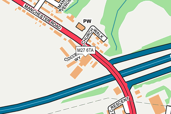
M27 6TA is located in the Pendlebury & Clifton electoral ward, within the metropolitan district of Salford and the English Parliamentary constituency of Salford and Eccles. The Sub Integrated Care Board (ICB) Location is NHS Greater Manchester ICB - 01G and the police force is Greater Manchester. This postcode has been in use since May 1994.


GetTheData
Source: OS OpenMap – Local (Ordnance Survey)
Source: OS VectorMap District (Ordnance Survey)
Licence: Open Government Licence (requires attribution)
| Easting | 377665 |
| Northing | 403377 |
| Latitude | 53.526593 |
| Longitude | -2.338382 |
GetTheData
Source: Open Postcode Geo
Licence: Open Government Licence
| Country | England |
| Postcode District | M27 |
➜ See where M27 is on a map ➜ Where is Clifton? | |
GetTheData
Source: Land Registry Price Paid Data
Licence: Open Government Licence
Elevation or altitude of M27 6TA as distance above sea level:
| Metres | Feet | |
|---|---|---|
| Elevation | 80m | 262ft |
Elevation is measured from the approximate centre of the postcode, to the nearest point on an OS contour line from OS Terrain 50, which has contour spacing of ten vertical metres.
➜ How high above sea level am I? Find the elevation of your current position using your device's GPS.
GetTheData
Source: Open Postcode Elevation
Licence: Open Government Licence
| Ward | Pendlebury & Clifton |
| Constituency | Salford And Eccles |
GetTheData
Source: ONS Postcode Database
Licence: Open Government Licence
| Manchester Rd/St. Anne's Church (Manchester Rd) | Clifton | 132m |
| Manchester Rd/St. Anne's Church (Manchester Rd) | Clifton | 164m |
| Manchester Rd/Golden Lion (Manchester Rd) | Clifton | 266m |
| Manchester Rd/Golden Lion (Manchester Rd) | Clifton | 320m |
| Manchester Rd/Moss Colliery Rd (Manchester Rd) | Clifton | 410m |
| Swinton (Manchester) Station | 1.3km |
| Moorside Station | 1.5km |
| Clifton (Manchester) Station | 1.6km |
GetTheData
Source: NaPTAN
Licence: Open Government Licence
| Percentage of properties with Next Generation Access | 100.0% |
| Percentage of properties with Superfast Broadband | 100.0% |
| Percentage of properties with Ultrafast Broadband | 0.0% |
| Percentage of properties with Full Fibre Broadband | 0.0% |
Superfast Broadband is between 30Mbps and 300Mbps
Ultrafast Broadband is > 300Mbps
| Percentage of properties unable to receive 2Mbps | 0.0% |
| Percentage of properties unable to receive 5Mbps | 0.0% |
| Percentage of properties unable to receive 10Mbps | 0.0% |
| Percentage of properties unable to receive 30Mbps | 0.0% |
GetTheData
Source: Ofcom
Licence: Ofcom Terms of Use (requires attribution)
GetTheData
Source: ONS Postcode Database
Licence: Open Government Licence


➜ Get more ratings from the Food Standards Agency
GetTheData
Source: Food Standards Agency
Licence: FSA terms & conditions
| Last Collection | |||
|---|---|---|---|
| Location | Mon-Fri | Sat | Distance |
| Swinton P.o. | 18:15 | 12:00 | 1,630m |
| Heywood Street | 17:30 | 12:00 | 1,821m |
| Market Place | 17:30 | 12:00 | 2,099m |
GetTheData
Source: Dracos
Licence: Creative Commons Attribution-ShareAlike
The below table lists the International Territorial Level (ITL) codes (formerly Nomenclature of Territorial Units for Statistics (NUTS) codes) and Local Administrative Units (LAU) codes for M27 6TA:
| ITL 1 Code | Name |
|---|---|
| TLD | North West (England) |
| ITL 2 Code | Name |
| TLD3 | Greater Manchester |
| ITL 3 Code | Name |
| TLD34 | Greater Manchester South West |
| LAU 1 Code | Name |
| E08000006 | Salford |
GetTheData
Source: ONS Postcode Directory
Licence: Open Government Licence
The below table lists the Census Output Area (OA), Lower Layer Super Output Area (LSOA), and Middle Layer Super Output Area (MSOA) for M27 6TA:
| Code | Name | |
|---|---|---|
| OA | E00028708 | |
| LSOA | E01005677 | Salford 005D |
| MSOA | E02001161 | Salford 005 |
GetTheData
Source: ONS Postcode Directory
Licence: Open Government Licence
| M27 6PN | Manchester Road | 62m |
| M27 6PW | Church Walk | 85m |
| M27 4LA | Collegiate Way | 98m |
| M27 6PJ | Fitton Crescent | 203m |
| M27 6PE | Manchester Road | 203m |
| M27 6PP | Manchester Road | 233m |
| M27 6PU | Manchester Road | 248m |
| M27 6PQ | Manley Avenue | 264m |
| M27 8PH | Manchester Road | 333m |
| M27 6PG | Galloway Drive | 347m |
GetTheData
Source: Open Postcode Geo; Land Registry Price Paid Data
Licence: Open Government Licence