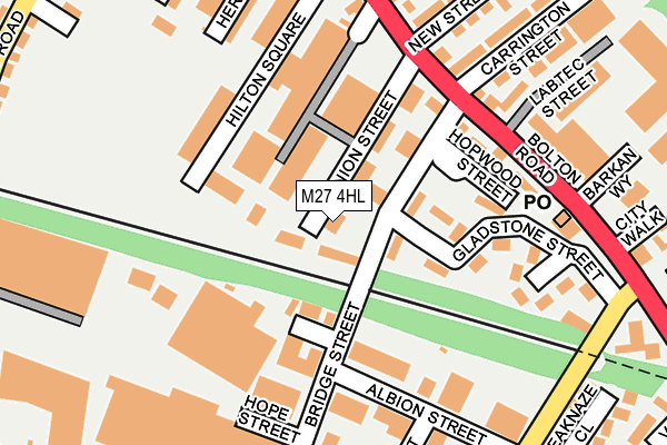
M27 4HL lies on Union Street in Pendlebury, Manchester. M27 4HL is located in the Pendlebury & Clifton electoral ward, within the metropolitan district of Salford and the English Parliamentary constituency of Salford and Eccles. The Sub Integrated Care Board (ICB) Location is NHS Greater Manchester ICB - 01G and the police force is Greater Manchester. This postcode has been in use since May 1994.


GetTheData
Source: OS OpenMap – Local (Ordnance Survey)
Source: OS VectorMap District (Ordnance Survey)
Licence: Open Government Licence (requires attribution)
| Easting | 378372 |
| Northing | 401941 |
| Latitude | 53.513716 |
| Longitude | -2.327618 |
GetTheData
Source: Open Postcode Geo
Licence: Open Government Licence
| Street | Union Street |
| Locality | Pendlebury |
| Town/City | Manchester |
| Country | England |
| Postcode District | M27 |
➜ See where M27 is on a map ➜ Where is Pendlebury? | |
GetTheData
Source: Land Registry Price Paid Data
Licence: Open Government Licence
Elevation or altitude of M27 4HL as distance above sea level:
| Metres | Feet | |
|---|---|---|
| Elevation | 80m | 262ft |
Elevation is measured from the approximate centre of the postcode, to the nearest point on an OS contour line from OS Terrain 50, which has contour spacing of ten vertical metres.
➜ How high above sea level am I? Find the elevation of your current position using your device's GPS.
GetTheData
Source: Open Postcode Elevation
Licence: Open Government Licence
| Ward | Pendlebury & Clifton |
| Constituency | Salford And Eccles |
GetTheData
Source: ONS Postcode Database
Licence: Open Government Licence
SACHA HOUSE, UNION STREET, PENDLEBURY, MANCHESTER, M27 4HL 2019 28 NOV £275,000 |
1 - 3, UNION STREET, PENDLEBURY, MANCHESTER, M27 4HL 2004 24 SEP £77,600 |
GetTheData
Source: HM Land Registry Price Paid Data
Licence: Contains HM Land Registry data © Crown copyright and database right 2025. This data is licensed under the Open Government Licence v3.0.
| Bolton Rd/Royal Oak (Bolton Rd) | Pendlebury | 179m |
| Bolton Rd/Royal Oak (Bolton Rd) | Pendlebury | 215m |
| Bolton Rd/Swinton Hall Rd (Bolton Rd) | Pendlebury | 246m |
| Bolton Rd/Swinton Hall Rd (Bolton Rd) | Pendlebury | 297m |
| Bolton Rd/Pendlebury Rd (Bolton Rd) | Pendlebury | 364m |
| Swinton (Manchester) Station | 0.7km |
| Clifton (Manchester) Station | 1.3km |
| Moorside Station | 1.6km |
GetTheData
Source: NaPTAN
Licence: Open Government Licence
GetTheData
Source: ONS Postcode Database
Licence: Open Government Licence


➜ Get more ratings from the Food Standards Agency
GetTheData
Source: Food Standards Agency
Licence: FSA terms & conditions
| Last Collection | |||
|---|---|---|---|
| Location | Mon-Fri | Sat | Distance |
| Swinton P.o. | 18:15 | 12:00 | 137m |
| Temple Drive | 17:30 | 12:00 | 679m |
| Market Place | 17:30 | 12:00 | 734m |
GetTheData
Source: Dracos
Licence: Creative Commons Attribution-ShareAlike
The below table lists the International Territorial Level (ITL) codes (formerly Nomenclature of Territorial Units for Statistics (NUTS) codes) and Local Administrative Units (LAU) codes for M27 4HL:
| ITL 1 Code | Name |
|---|---|
| TLD | North West (England) |
| ITL 2 Code | Name |
| TLD3 | Greater Manchester |
| ITL 3 Code | Name |
| TLD34 | Greater Manchester South West |
| LAU 1 Code | Name |
| E08000006 | Salford |
GetTheData
Source: ONS Postcode Directory
Licence: Open Government Licence
The below table lists the Census Output Area (OA), Lower Layer Super Output Area (LSOA), and Middle Layer Super Output Area (MSOA) for M27 4HL:
| Code | Name | |
|---|---|---|
| OA | E00028731 | |
| LSOA | E01005671 | Salford 012A |
| MSOA | E02001168 | Salford 012 |
GetTheData
Source: ONS Postcode Directory
Licence: Open Government Licence
| M27 4DS | Bridge Street | 61m |
| M27 4DP | Bridge Street | 83m |
| M27 4DD | Cavendish Place | 96m |
| M27 4DQ | Gladstone Street | 171m |
| M27 8UR | Bolton Road | 174m |
| M27 8BH | Carrington Street | 199m |
| M27 8BB | Bolton Road | 204m |
| M27 4DL | Bolton Road | 210m |
| M27 4DJ | Heron Street | 218m |
| M27 8GS | New Street | 227m |
GetTheData
Source: Open Postcode Geo; Land Registry Price Paid Data
Licence: Open Government Licence