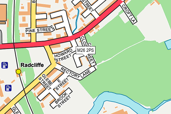
M26 2PS lies on Cock Clod Street in Radcliffe, Manchester. M26 2PS is located in the Radcliffe East electoral ward, within the metropolitan district of Bury and the English Parliamentary constituency of Bury South. The Sub Integrated Care Board (ICB) Location is NHS Greater Manchester ICB - 00V and the police force is Greater Manchester. This postcode has been in use since May 1994.


GetTheData
Source: OS OpenMap – Local (Ordnance Survey)
Source: OS VectorMap District (Ordnance Survey)
Licence: Open Government Licence (requires attribution)
| Easting | 379072 |
| Northing | 407404 |
| Latitude | 53.562845 |
| Longitude | -2.317429 |
GetTheData
Source: Open Postcode Geo
Licence: Open Government Licence
| Street | Cock Clod Street |
| Locality | Radcliffe |
| Town/City | Manchester |
| Country | England |
| Postcode District | M26 |
➜ See where M26 is on a map ➜ Where is Radcliffe? | |
GetTheData
Source: Land Registry Price Paid Data
Licence: Open Government Licence
Elevation or altitude of M26 2PS as distance above sea level:
| Metres | Feet | |
|---|---|---|
| Elevation | 60m | 197ft |
Elevation is measured from the approximate centre of the postcode, to the nearest point on an OS contour line from OS Terrain 50, which has contour spacing of ten vertical metres.
➜ How high above sea level am I? Find the elevation of your current position using your device's GPS.
GetTheData
Source: Open Postcode Elevation
Licence: Open Government Licence
| Ward | Radcliffe East |
| Constituency | Bury South |
GetTheData
Source: ONS Postcode Database
Licence: Open Government Licence
| Cross Ln/Cheetham St (Cross Ln) | Radcliffe | 89m |
| Cross Ln/Butterworth St (Cross Ln) | Radcliffe | 90m |
| Cross Ln/Croft Ln (Cross Ln) | Radcliffe | 213m |
| Bury Rd/Spring Ln (Bury Rd) | Radcliffe | 221m |
| Bury Rd/Schofield St (Bury Rd) | Radcliffe | 225m |
| Radcliffe (Manchester Metrolink) (Off Spring Lane) | Radcliffe | 280m |
| Whitefield (Manchester Metrolink) (Bury New Road) | Whitefield | 1,959m |
| Kearsley Station | 4.4km |
| Clifton (Manchester) Station | 4.5km |
| Farnworth Station | 4.9km |
GetTheData
Source: NaPTAN
Licence: Open Government Licence
| Percentage of properties with Next Generation Access | 100.0% |
| Percentage of properties with Superfast Broadband | 100.0% |
| Percentage of properties with Ultrafast Broadband | 100.0% |
| Percentage of properties with Full Fibre Broadband | 100.0% |
Superfast Broadband is between 30Mbps and 300Mbps
Ultrafast Broadband is > 300Mbps
| Percentage of properties unable to receive 2Mbps | 0.0% |
| Percentage of properties unable to receive 5Mbps | 0.0% |
| Percentage of properties unable to receive 10Mbps | 0.0% |
| Percentage of properties unable to receive 30Mbps | 0.0% |
GetTheData
Source: Ofcom
Licence: Ofcom Terms of Use (requires attribution)
Estimated total energy consumption in M26 2PS by fuel type, 2015.
| Consumption (kWh) | 45,415 |
|---|---|
| Meter count | 6 |
| Mean (kWh/meter) | 7,569 |
| Median (kWh/meter) | 7,026 |
GetTheData
Source: Postcode level gas estimates: 2015 (experimental)
Source: Postcode level electricity estimates: 2015 (experimental)
Licence: Open Government Licence
GetTheData
Source: ONS Postcode Database
Licence: Open Government Licence


➜ Get more ratings from the Food Standards Agency
GetTheData
Source: Food Standards Agency
Licence: FSA terms & conditions
| Last Collection | |||
|---|---|---|---|
| Location | Mon-Fri | Sat | Distance |
| Rectory Lane | 17:30 | 12:00 | 131m |
| Radcliffe P.o. | 17:30 | 12:00 | 741m |
| Radcliffe P.o. | 17:30 | 12:00 | 742m |
GetTheData
Source: Dracos
Licence: Creative Commons Attribution-ShareAlike
The below table lists the International Territorial Level (ITL) codes (formerly Nomenclature of Territorial Units for Statistics (NUTS) codes) and Local Administrative Units (LAU) codes for M26 2PS:
| ITL 1 Code | Name |
|---|---|
| TLD | North West (England) |
| ITL 2 Code | Name |
| TLD3 | Greater Manchester |
| ITL 3 Code | Name |
| TLD37 | Greater Manchester North East |
| LAU 1 Code | Name |
| E08000002 | Bury |
GetTheData
Source: ONS Postcode Directory
Licence: Open Government Licence
The below table lists the Census Output Area (OA), Lower Layer Super Output Area (LSOA), and Middle Layer Super Output Area (MSOA) for M26 2PS:
| Code | Name | |
|---|---|---|
| OA | E00025265 | |
| LSOA | E01004994 | Bury 015D |
| MSOA | E02001033 | Bury 015 |
GetTheData
Source: ONS Postcode Directory
Licence: Open Government Licence
| M26 2PR | Baybutt Street | 24m |
| M26 2GG | Pollitt Street | 70m |
| M26 2GU | Howard Street | 88m |
| M26 2GY | Cross Lane | 102m |
| M26 2QU | Rectory Lane | 120m |
| M26 2QX | Spring Lane | 120m |
| M26 2BY | Church Street West | 138m |
| M26 2PN | East Street | 153m |
| M26 2QZ | Cross Lane | 157m |
| M26 2FU | Jones Street | 159m |
GetTheData
Source: Open Postcode Geo; Land Registry Price Paid Data
Licence: Open Government Licence