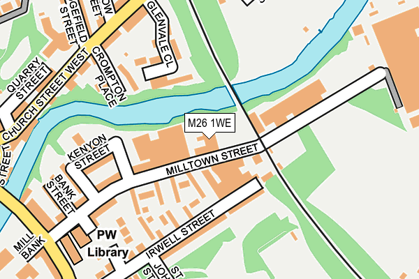
M26 1WE is located in the Radcliffe East electoral ward, within the metropolitan district of Bury and the English Parliamentary constituency of Bury South. The Sub Integrated Care Board (ICB) Location is NHS Greater Manchester ICB - 00V and the police force is Greater Manchester. This postcode has been in use since June 1997.


GetTheData
Source: OS OpenMap – Local (Ordnance Survey)
Source: OS VectorMap District (Ordnance Survey)
Licence: Open Government Licence (requires attribution)
| Easting | 378889 |
| Northing | 407015 |
| Latitude | 53.559342 |
| Longitude | -2.320166 |
GetTheData
Source: Open Postcode Geo
Licence: Open Government Licence
| Country | England |
| Postcode District | M26 |
➜ See where M26 is on a map ➜ Where is Radcliffe? | |
GetTheData
Source: Land Registry Price Paid Data
Licence: Open Government Licence
Elevation or altitude of M26 1WE as distance above sea level:
| Metres | Feet | |
|---|---|---|
| Elevation | 60m | 197ft |
Elevation is measured from the approximate centre of the postcode, to the nearest point on an OS contour line from OS Terrain 50, which has contour spacing of ten vertical metres.
➜ How high above sea level am I? Find the elevation of your current position using your device's GPS.
GetTheData
Source: Open Postcode Elevation
Licence: Open Government Licence
| Ward | Radcliffe East |
| Constituency | Bury South |
GetTheData
Source: ONS Postcode Database
Licence: Open Government Licence
| Stand Ln/Radcliffe Library (Stand Ln) | Chapel Field | 248m |
| Church St/Radcliffe Tram Stop (Church Street) | Radcliffe | 258m |
| Stand Ln/Radcliffe Library (Stand Ln) | Chapel Field | 260m |
| Radcliffe New Rd/Stand Ln (Radcliffe New R) | Chapel Field | 263m |
| Radcliffe New Rd/Stand Ln (Radcliffe New R) | Chapel Field | 269m |
| Radcliffe (Manchester Metrolink) (Off Spring Lane) | Radcliffe | 331m |
| Kearsley Station | 4km |
| Clifton (Manchester) Station | 4.1km |
| Farnworth Station | 4.6km |
GetTheData
Source: NaPTAN
Licence: Open Government Licence
GetTheData
Source: ONS Postcode Database
Licence: Open Government Licence

➜ Get more ratings from the Food Standards Agency
GetTheData
Source: Food Standards Agency
Licence: FSA terms & conditions
| Last Collection | |||
|---|---|---|---|
| Location | Mon-Fri | Sat | Distance |
| Radcliffe P.o. | 17:30 | 12:00 | 416m |
| Radcliffe P.o. | 17:30 | 12:00 | 416m |
| Rectory Lane | 17:30 | 12:00 | 428m |
GetTheData
Source: Dracos
Licence: Creative Commons Attribution-ShareAlike
The below table lists the International Territorial Level (ITL) codes (formerly Nomenclature of Territorial Units for Statistics (NUTS) codes) and Local Administrative Units (LAU) codes for M26 1WE:
| ITL 1 Code | Name |
|---|---|
| TLD | North West (England) |
| ITL 2 Code | Name |
| TLD3 | Greater Manchester |
| ITL 3 Code | Name |
| TLD37 | Greater Manchester North East |
| LAU 1 Code | Name |
| E08000002 | Bury |
GetTheData
Source: ONS Postcode Directory
Licence: Open Government Licence
The below table lists the Census Output Area (OA), Lower Layer Super Output Area (LSOA), and Middle Layer Super Output Area (MSOA) for M26 1WE:
| Code | Name | |
|---|---|---|
| OA | E00171712 | |
| LSOA | E01005009 | Bury 016E |
| MSOA | E02001034 | Bury 016 |
GetTheData
Source: ONS Postcode Directory
Licence: Open Government Licence
| M26 1WF | Milltown Close | 83m |
| M26 1LR | Irwell Street | 126m |
| M26 1NF | Kenyon Street | 150m |
| M26 1ED | Bridge Close | 157m |
| M26 1WD | Milltown Street | 159m |
| M26 1NZ | River Street | 190m |
| M26 1NE | Bank Street | 205m |
| M26 2SY | Church Street West | 222m |
| M26 2SX | Church Street West | 245m |
| M26 2SQ | Church Street West | 247m |
GetTheData
Source: Open Postcode Geo; Land Registry Price Paid Data
Licence: Open Government Licence