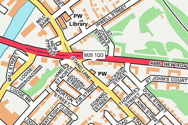
M26 1QG lies on New Road in Radcliffe, Manchester. M26 1QG is located in the Radcliffe West electoral ward, within the metropolitan district of Bury and the English Parliamentary constituency of Bury South. The Sub Integrated Care Board (ICB) Location is NHS Greater Manchester ICB - 00V and the police force is Greater Manchester. This postcode has been in use since July 2006.


GetTheData
Source: OS OpenMap – Local (Ordnance Survey)
Source: OS VectorMap District (Ordnance Survey)
Licence: Open Government Licence (requires attribution)
| Easting | 378806 |
| Northing | 406749 |
| Latitude | 53.556932 |
| Longitude | -2.321403 |
GetTheData
Source: Open Postcode Geo
Licence: Open Government Licence
| Street | New Road |
| Locality | Radcliffe |
| Town/City | Manchester |
| Country | England |
| Postcode District | M26 |
➜ See where M26 is on a map ➜ Where is Radcliffe? | |
GetTheData
Source: Land Registry Price Paid Data
Licence: Open Government Licence
Elevation or altitude of M26 1QG as distance above sea level:
| Metres | Feet | |
|---|---|---|
| Elevation | 70m | 230ft |
Elevation is measured from the approximate centre of the postcode, to the nearest point on an OS contour line from OS Terrain 50, which has contour spacing of ten vertical metres.
➜ How high above sea level am I? Find the elevation of your current position using your device's GPS.
GetTheData
Source: Open Postcode Elevation
Licence: Open Government Licence
| Ward | Radcliffe West |
| Constituency | Bury South |
GetTheData
Source: ONS Postcode Database
Licence: Open Government Licence
| Radcliffe New Rd/Stand Ln (Radcliffe New R) | Chapel Field | 11m |
| Radcliffe New Rd/Stand Ln (Radcliffe New R) | Chapel Field | 42m |
| Stand Ln/Edward St (Stand Ln) | Chapel Field | 100m |
| Stand Ln/British Queen (Stand Ln) | Chapel Field | 105m |
| Stand Ln/Radcliffe Library (Stand Ln) | Chapel Field | 165m |
| Radcliffe (Manchester Metrolink) (Off Spring Lane) | Radcliffe | 585m |
| Kearsley Station | 3.8km |
| Clifton (Manchester) Station | 3.9km |
| Farnworth Station | 4.5km |
GetTheData
Source: NaPTAN
Licence: Open Government Licence
| Median download speed | 31.4Mbps |
| Average download speed | 41.3Mbps |
| Maximum download speed | 80.00Mbps |
| Median upload speed | 5.6Mbps |
| Average upload speed | 8.3Mbps |
| Maximum upload speed | 20.00Mbps |
GetTheData
Source: Ofcom
Licence: Ofcom Terms of Use (requires attribution)
Estimated total energy consumption in M26 1QG by fuel type, 2015.
| Consumption (kWh) | 109,413 |
|---|---|
| Meter count | 18 |
| Mean (kWh/meter) | 6,078 |
| Median (kWh/meter) | 5,564 |
GetTheData
Source: Postcode level gas estimates: 2015 (experimental)
Source: Postcode level electricity estimates: 2015 (experimental)
Licence: Open Government Licence
GetTheData
Source: ONS Postcode Database
Licence: Open Government Licence


➜ Get more ratings from the Food Standards Agency
GetTheData
Source: Food Standards Agency
Licence: FSA terms & conditions
| Last Collection | |||
|---|---|---|---|
| Location | Mon-Fri | Sat | Distance |
| Radcliffe P.o. | 17:30 | 12:00 | 391m |
| Radcliffe P.o. | 17:30 | 12:00 | 393m |
| Asda | 17:30 | 12:00 | 443m |
GetTheData
Source: Dracos
Licence: Creative Commons Attribution-ShareAlike
The below table lists the International Territorial Level (ITL) codes (formerly Nomenclature of Territorial Units for Statistics (NUTS) codes) and Local Administrative Units (LAU) codes for M26 1QG:
| ITL 1 Code | Name |
|---|---|
| TLD | North West (England) |
| ITL 2 Code | Name |
| TLD3 | Greater Manchester |
| ITL 3 Code | Name |
| TLD37 | Greater Manchester North East |
| LAU 1 Code | Name |
| E08000002 | Bury |
GetTheData
Source: ONS Postcode Directory
Licence: Open Government Licence
The below table lists the Census Output Area (OA), Lower Layer Super Output Area (LSOA), and Middle Layer Super Output Area (MSOA) for M26 1QG:
| Code | Name | |
|---|---|---|
| OA | E00171712 | |
| LSOA | E01005009 | Bury 016E |
| MSOA | E02001034 | Bury 016 |
GetTheData
Source: ONS Postcode Directory
Licence: Open Government Licence
| M26 1JU | Stand Lane | 58m |
| M26 1LQ | Stand Lane | 77m |
| M26 1JX | Joseph Street | 84m |
| M26 1LS | New Road | 94m |
| M26 1QQ | James Street North | 109m |
| M26 1LL | James Street North | 127m |
| M26 1JY | Morton Street | 130m |
| M26 1UB | Lawndale Close | 154m |
| M26 1LR | Irwell Street | 155m |
| M26 1ED | Bridge Close | 156m |
GetTheData
Source: Open Postcode Geo; Land Registry Price Paid Data
Licence: Open Government Licence