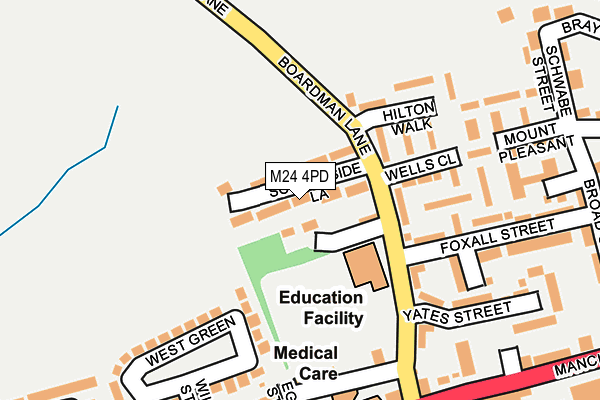
M24 4PD lies on Schoolside Lane in Middleton, Manchester. M24 4PD is located in the South Middleton electoral ward, within the metropolitan district of Rochdale and the English Parliamentary constituency of Heywood and Middleton. The Sub Integrated Care Board (ICB) Location is NHS Greater Manchester ICB - 01D and the police force is Greater Manchester. This postcode has been in use since January 1980.


GetTheData
Source: OS OpenMap – Local (Ordnance Survey)
Source: OS VectorMap District (Ordnance Survey)
Licence: Open Government Licence (requires attribution)
| Easting | 385041 |
| Northing | 405458 |
| Latitude | 53.545544 |
| Longitude | -2.227222 |
GetTheData
Source: Open Postcode Geo
Licence: Open Government Licence
| Street | Schoolside Lane |
| Locality | Middleton |
| Town/City | Manchester |
| Country | England |
| Postcode District | M24 |
➜ See where M24 is on a map ➜ Where is Rhodes? | |
GetTheData
Source: Land Registry Price Paid Data
Licence: Open Government Licence
Elevation or altitude of M24 4PD as distance above sea level:
| Metres | Feet | |
|---|---|---|
| Elevation | 80m | 262ft |
Elevation is measured from the approximate centre of the postcode, to the nearest point on an OS contour line from OS Terrain 50, which has contour spacing of ten vertical metres.
➜ How high above sea level am I? Find the elevation of your current position using your device's GPS.
GetTheData
Source: Open Postcode Elevation
Licence: Open Government Licence
| Ward | South Middleton |
| Constituency | Heywood And Middleton |
GetTheData
Source: ONS Postcode Database
Licence: Open Government Licence
34, SCHOOLSIDE LANE, MIDDLETON, MANCHESTER, M24 4PD 2018 26 OCT £525,000 |
GetTheData
Source: HM Land Registry Price Paid Data
Licence: Contains HM Land Registry data © Crown copyright and database right 2025. This data is licensed under the Open Government Licence v3.0.
| Boardman Lane/Hilton Walk (Boardman Lane) | Rhodes | 90m |
| Boardman Lane (Nw Bnd) (Boardman Lane) | Rhodes | 213m |
| Manchester Old Rd/Boardman Ln (M/Cr Old R) | Rhodes | 244m |
| Manchester Old Rd/Boardman Ln (M/Cr Old Road) | Rhodes | 244m |
| Manchester Old Rd/Broad St (M/Cr Old Road) | Rhodes | 330m |
| Mills Hill (Manchester) Station | 3.7km |
| Moston Station | 4.5km |
GetTheData
Source: NaPTAN
Licence: Open Government Licence
| Percentage of properties with Next Generation Access | 100.0% |
| Percentage of properties with Superfast Broadband | 100.0% |
| Percentage of properties with Ultrafast Broadband | 0.0% |
| Percentage of properties with Full Fibre Broadband | 0.0% |
Superfast Broadband is between 30Mbps and 300Mbps
Ultrafast Broadband is > 300Mbps
| Median download speed | 27.5Mbps |
| Average download speed | 24.0Mbps |
| Maximum download speed | 39.05Mbps |
| Median upload speed | 5.2Mbps |
| Average upload speed | 4.6Mbps |
| Maximum upload speed | 9.31Mbps |
| Percentage of properties unable to receive 2Mbps | 0.0% |
| Percentage of properties unable to receive 5Mbps | 0.0% |
| Percentage of properties unable to receive 10Mbps | 0.0% |
| Percentage of properties unable to receive 30Mbps | 0.0% |
GetTheData
Source: Ofcom
Licence: Ofcom Terms of Use (requires attribution)
Estimated total energy consumption in M24 4PD by fuel type, 2015.
| Consumption (kWh) | 452,939 |
|---|---|
| Meter count | 39 |
| Mean (kWh/meter) | 11,614 |
| Median (kWh/meter) | 10,995 |
| Consumption (kWh) | 111,497 |
|---|---|
| Meter count | 36 |
| Mean (kWh/meter) | 3,097 |
| Median (kWh/meter) | 2,961 |
GetTheData
Source: Postcode level gas estimates: 2015 (experimental)
Source: Postcode level electricity estimates: 2015 (experimental)
Licence: Open Government Licence
GetTheData
Source: ONS Postcode Database
Licence: Open Government Licence


➜ Get more ratings from the Food Standards Agency
GetTheData
Source: Food Standards Agency
Licence: FSA terms & conditions
| Last Collection | |||
|---|---|---|---|
| Location | Mon-Fri | Sat | Distance |
| Heywood Old Road | 17:30 | 12:00 | 517m |
| Bowness Road P.o. | 17:30 | 12:00 | 960m |
| 31 Chain Road | 17:30 | 11:45 | 978m |
GetTheData
Source: Dracos
Licence: Creative Commons Attribution-ShareAlike
The below table lists the International Territorial Level (ITL) codes (formerly Nomenclature of Territorial Units for Statistics (NUTS) codes) and Local Administrative Units (LAU) codes for M24 4PD:
| ITL 1 Code | Name |
|---|---|
| TLD | North West (England) |
| ITL 2 Code | Name |
| TLD3 | Greater Manchester |
| ITL 3 Code | Name |
| TLD37 | Greater Manchester North East |
| LAU 1 Code | Name |
| E08000005 | Rochdale |
GetTheData
Source: ONS Postcode Directory
Licence: Open Government Licence
The below table lists the Census Output Area (OA), Lower Layer Super Output Area (LSOA), and Middle Layer Super Output Area (MSOA) for M24 4PD:
| Code | Name | |
|---|---|---|
| OA | E00028074 | |
| LSOA | E01005547 | Rochdale 024D |
| MSOA | E02001155 | Rochdale 024 |
GetTheData
Source: ONS Postcode Directory
Licence: Open Government Licence
| M24 4TU | Boardman Lane | 58m |
| M24 4PU | Boardman Lane | 99m |
| M24 4PX | Wells Close | 120m |
| M24 4QA | Boardman Lane | 145m |
| M24 4PS | Hilton Walk | 154m |
| M24 4PY | Clarkson Close | 167m |
| M24 4HL | Foxall Close | 170m |
| M24 4GE | West Green | 177m |
| M24 4QE | Walker Street | 212m |
| M24 4PR | Mount Pleasant | 212m |
GetTheData
Source: Open Postcode Geo; Land Registry Price Paid Data
Licence: Open Government Licence