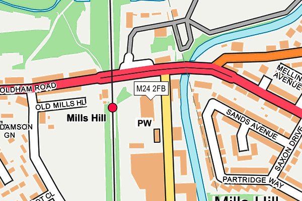
M24 2FB is located in the East Middleton electoral ward, within the metropolitan district of Rochdale and the English Parliamentary constituency of Heywood and Middleton. The Sub Integrated Care Board (ICB) Location is NHS Greater Manchester ICB - 01D and the police force is Greater Manchester. This postcode has been in use since January 1980.


GetTheData
Source: OS OpenMap – Local (Ordnance Survey)
Source: OS VectorMap District (Ordnance Survey)
Licence: Open Government Licence (requires attribution)
| Easting | 388814 |
| Northing | 406047 |
| Latitude | 53.550933 |
| Longitude | -2.170304 |
GetTheData
Source: Open Postcode Geo
Licence: Open Government Licence
| Country | England |
| Postcode District | M24 |
➜ See where M24 is on a map ➜ Where is Middleton? | |
GetTheData
Source: Land Registry Price Paid Data
Licence: Open Government Licence
Elevation or altitude of M24 2FB as distance above sea level:
| Metres | Feet | |
|---|---|---|
| Elevation | 110m | 361ft |
Elevation is measured from the approximate centre of the postcode, to the nearest point on an OS contour line from OS Terrain 50, which has contour spacing of ten vertical metres.
➜ How high above sea level am I? Find the elevation of your current position using your device's GPS.
GetTheData
Source: Open Postcode Elevation
Licence: Open Government Licence
| Ward | East Middleton |
| Constituency | Heywood And Middleton |
GetTheData
Source: ONS Postcode Database
Licence: Open Government Licence
| Oldham Rd/Mills Hill Stn (Oldham Rd) | Mills Hill | 62m |
| Oldham Rd/Mills Hill Stn (Oldham Rd) | Mills Hill | 80m |
| Mills Hill Rd/Baptist Church (Mills Hill Rd) | Mills Hill | 98m |
| Mills Hill Rd/Baptist Church (Mills Hill Rd) | Mills Hill | 184m |
| Oldham Rd/Baytree Ln (Oldham Rd) | Mills Hill | 225m |
| Mills Hill (Manchester) Station | 0.1km |
| Moston Station | 3.1km |
| Castleton (Manchester) Station | 4.6km |
GetTheData
Source: NaPTAN
Licence: Open Government Licence
GetTheData
Source: ONS Postcode Database
Licence: Open Government Licence


➜ Get more ratings from the Food Standards Agency
GetTheData
Source: Food Standards Agency
Licence: FSA terms & conditions
| Last Collection | |||
|---|---|---|---|
| Location | Mon-Fri | Sat | Distance |
| Baytree Lane / Mills Hill Road | 17:30 | 12:00 | 501m |
| Higher Tongue P.o. | 17:30 | 12:00 | 596m |
| Moor Close | 17:30 | 12:00 | 731m |
GetTheData
Source: Dracos
Licence: Creative Commons Attribution-ShareAlike
The below table lists the International Territorial Level (ITL) codes (formerly Nomenclature of Territorial Units for Statistics (NUTS) codes) and Local Administrative Units (LAU) codes for M24 2FB:
| ITL 1 Code | Name |
|---|---|
| TLD | North West (England) |
| ITL 2 Code | Name |
| TLD3 | Greater Manchester |
| ITL 3 Code | Name |
| TLD37 | Greater Manchester North East |
| LAU 1 Code | Name |
| E08000005 | Rochdale |
GetTheData
Source: ONS Postcode Directory
Licence: Open Government Licence
The below table lists the Census Output Area (OA), Lower Layer Super Output Area (LSOA), and Middle Layer Super Output Area (MSOA) for M24 2FB:
| Code | Name | |
|---|---|---|
| OA | E00028028 | |
| LSOA | E01005542 | Rochdale 023G |
| MSOA | E02001154 | Rochdale 023 |
GetTheData
Source: ONS Postcode Directory
Licence: Open Government Licence
| OL1 2TG | Middleton Road | 86m |
| M24 2FD | Mills Hill Road | 158m |
| OL9 9RL | Inglewood Road | 182m |
| OL9 0NT | Partridge Way | 185m |
| OL9 0NU | Sands Avenue | 188m |
| OL9 0NN | Middleton Road | 210m |
| OL9 0NR | Cloughs Avenue | 216m |
| OL9 9RN | Middleton Road | 225m |
| OL9 9SD | Corbrook Road | 226m |
| OL1 2TQ | Haigh Lane | 253m |
GetTheData
Source: Open Postcode Geo; Land Registry Price Paid Data
Licence: Open Government Licence