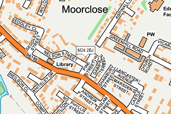
M24 2BJ lies on Pine Street in Middleton, Manchester. M24 2BJ is located in the East Middleton electoral ward, within the metropolitan district of Rochdale and the English Parliamentary constituency of Heywood and Middleton. The Sub Integrated Care Board (ICB) Location is NHS Greater Manchester ICB - 01D and the police force is Greater Manchester. This postcode has been in use since January 1980.


GetTheData
Source: OS OpenMap – Local (Ordnance Survey)
Source: OS VectorMap District (Ordnance Survey)
Licence: Open Government Licence (requires attribution)
| Easting | 388347 |
| Northing | 405260 |
| Latitude | 53.543849 |
| Longitude | -2.177323 |
GetTheData
Source: Open Postcode Geo
Licence: Open Government Licence
| Street | Pine Street |
| Locality | Middleton |
| Town/City | Manchester |
| Country | England |
| Postcode District | M24 |
➜ See where M24 is on a map ➜ Where is Middleton? | |
GetTheData
Source: Land Registry Price Paid Data
Licence: Open Government Licence
Elevation or altitude of M24 2BJ as distance above sea level:
| Metres | Feet | |
|---|---|---|
| Elevation | 100m | 328ft |
Elevation is measured from the approximate centre of the postcode, to the nearest point on an OS contour line from OS Terrain 50, which has contour spacing of ten vertical metres.
➜ How high above sea level am I? Find the elevation of your current position using your device's GPS.
GetTheData
Source: Open Postcode Elevation
Licence: Open Government Licence
| Ward | East Middleton |
| Constituency | Heywood And Middleton |
GetTheData
Source: ONS Postcode Database
Licence: Open Government Licence
| Greenhill Road (E Bnd) (Greenhill Road) | Moorclose | 108m |
| Grimshaw Ln/Haslam St (Grimshaw Ln) | Middleton Junction | 147m |
| Grimshaw Ln/Lonsdale Ct (Grimshaw Ln) | Moorclose | 177m |
| Grimshaw Ln/Castle St (Grimshaw Ln) | Middleton Junction | 203m |
| Grimshaw Ln/Lonsdale Ct (Grimshaw Ln) | Moorclose | 238m |
| Mills Hill (Manchester) Station | 0.9km |
| Moston Station | 2.3km |
GetTheData
Source: NaPTAN
Licence: Open Government Licence
| Percentage of properties with Next Generation Access | 100.0% |
| Percentage of properties with Superfast Broadband | 100.0% |
| Percentage of properties with Ultrafast Broadband | 100.0% |
| Percentage of properties with Full Fibre Broadband | 0.0% |
Superfast Broadband is between 30Mbps and 300Mbps
Ultrafast Broadband is > 300Mbps
| Percentage of properties unable to receive 2Mbps | 0.0% |
| Percentage of properties unable to receive 5Mbps | 0.0% |
| Percentage of properties unable to receive 10Mbps | 0.0% |
| Percentage of properties unable to receive 30Mbps | 0.0% |
GetTheData
Source: Ofcom
Licence: Ofcom Terms of Use (requires attribution)
GetTheData
Source: ONS Postcode Database
Licence: Open Government Licence


➜ Get more ratings from the Food Standards Agency
GetTheData
Source: Food Standards Agency
Licence: FSA terms & conditions
| Last Collection | |||
|---|---|---|---|
| Location | Mon-Fri | Sat | Distance |
| Middleton Junction P.o. | 17:30 | 12:00 | 236m |
| Moor Close | 17:30 | 12:00 | 442m |
| Greengate | 530m | ||
GetTheData
Source: Dracos
Licence: Creative Commons Attribution-ShareAlike
The below table lists the International Territorial Level (ITL) codes (formerly Nomenclature of Territorial Units for Statistics (NUTS) codes) and Local Administrative Units (LAU) codes for M24 2BJ:
| ITL 1 Code | Name |
|---|---|
| TLD | North West (England) |
| ITL 2 Code | Name |
| TLD3 | Greater Manchester |
| ITL 3 Code | Name |
| TLD37 | Greater Manchester North East |
| LAU 1 Code | Name |
| E08000005 | Rochdale |
GetTheData
Source: ONS Postcode Directory
Licence: Open Government Licence
The below table lists the Census Output Area (OA), Lower Layer Super Output Area (LSOA), and Middle Layer Super Output Area (MSOA) for M24 2BJ:
| Code | Name | |
|---|---|---|
| OA | E00028002 | |
| LSOA | E01005535 | Rochdale 023B |
| MSOA | E02001154 | Rochdale 023 |
GetTheData
Source: ONS Postcode Directory
Licence: Open Government Licence
| M24 2UY | St Gabriels Mews | 76m |
| M24 2AL | Grimshaw Lane | 92m |
| M24 2BN | Nelson Street | 98m |
| M24 2LN | Butterworth Street | 112m |
| M24 2BD | Greenhill Road | 133m |
| M24 2LG | Marsden Street | 137m |
| M24 2AR | Lancaster Avenue | 148m |
| M24 2AQ | Phyllis Street | 159m |
| M24 2SG | Greenhill Terrace | 159m |
| M24 2AN | Andrew Street | 165m |
GetTheData
Source: Open Postcode Geo; Land Registry Price Paid Data
Licence: Open Government Licence