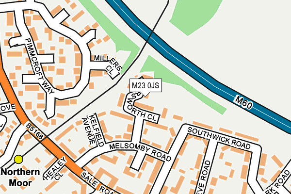
M23 0JS lies on Marsworth Close in Manchester. M23 0JS is located in the Brooklands electoral ward, within the metropolitan district of Manchester and the English Parliamentary constituency of Wythenshawe and Sale East. The Sub Integrated Care Board (ICB) Location is NHS Greater Manchester ICB - 14L and the police force is Greater Manchester. This postcode has been in use since February 2015.


GetTheData
Source: OS OpenMap – Local (Ordnance Survey)
Source: OS VectorMap District (Ordnance Survey)
Licence: Open Government Licence (requires attribution)
| Easting | 381203 |
| Northing | 391023 |
| Latitude | 53.415673 |
| Longitude | -2.284272 |
GetTheData
Source: Open Postcode Geo
Licence: Open Government Licence
| Street | Marsworth Close |
| Town/City | Manchester |
| Country | England |
| Postcode District | M23 |
➜ See where M23 is on a map ➜ Where is Wythenshawe? | |
GetTheData
Source: Land Registry Price Paid Data
Licence: Open Government Licence
Elevation or altitude of M23 0JS as distance above sea level:
| Metres | Feet | |
|---|---|---|
| Elevation | 30m | 98ft |
Elevation is measured from the approximate centre of the postcode, to the nearest point on an OS contour line from OS Terrain 50, which has contour spacing of ten vertical metres.
➜ How high above sea level am I? Find the elevation of your current position using your device's GPS.
GetTheData
Source: Open Postcode Elevation
Licence: Open Government Licence
| Ward | Brooklands |
| Constituency | Wythenshawe And Sale East |
GetTheData
Source: ONS Postcode Database
Licence: Open Government Licence
| Northern Moor Metrolink Stop (Sale Road) | Northern Moor | 212m |
| Northern Moor Metrolink Stop (Sale Road) | Northern Moor | 221m |
| Sale Rd/Brenchley Dr (Sale Rd) | Northern Moor | 244m |
| Sale Rd/Cleeve Rd (Sale Rd) | Northern Moor | 269m |
| Northenden Road/Norris Road (Northenden Road) | Sale Moor | 320m |
| Northern Moor (Manchester Metrolink) (Sale Road) | Northern Moor | 292m |
| Wythenshawe Park (Manchester Metrolink) (Wythenshawe Road) | Northern Moor | 1,170m |
| Sale Water Park (Manchester Metrolink) (Rifle Road) | Sale | 1,462m |
| Moor Road (Manchester Metrolink) (Moor Road) | Baguley | 1,546m |
| East Didsbury Station | 4.2km |
| Gatley Station | 4.3km |
| Navigation Road Station | 4.5km |
GetTheData
Source: NaPTAN
Licence: Open Government Licence
| Percentage of properties with Next Generation Access | 100.0% |
| Percentage of properties with Superfast Broadband | 100.0% |
| Percentage of properties with Ultrafast Broadband | 96.6% |
| Percentage of properties with Full Fibre Broadband | 0.0% |
Superfast Broadband is between 30Mbps and 300Mbps
Ultrafast Broadband is > 300Mbps
| Median download speed | 39.1Mbps |
| Average download speed | 31.7Mbps |
| Maximum download speed | 61.91Mbps |
| Median upload speed | 9.8Mbps |
| Average upload speed | 8.1Mbps |
| Maximum upload speed | 20.00Mbps |
| Percentage of properties unable to receive 2Mbps | 0.0% |
| Percentage of properties unable to receive 5Mbps | 0.0% |
| Percentage of properties unable to receive 10Mbps | 0.0% |
| Percentage of properties unable to receive 30Mbps | 0.0% |
GetTheData
Source: Ofcom
Licence: Ofcom Terms of Use (requires attribution)
Estimated total energy consumption in M23 0JS by fuel type, 2015.
| Consumption (kWh) | 240,731 |
|---|---|
| Meter count | 29 |
| Mean (kWh/meter) | 8,301 |
| Median (kWh/meter) | 8,211 |
| Consumption (kWh) | 79,998 |
|---|---|
| Meter count | 29 |
| Mean (kWh/meter) | 2,759 |
| Median (kWh/meter) | 2,383 |
GetTheData
Source: Postcode level gas estimates: 2015 (experimental)
Source: Postcode level electricity estimates: 2015 (experimental)
Licence: Open Government Licence
GetTheData
Source: ONS Postcode Database
Licence: Open Government Licence


➜ Get more ratings from the Food Standards Agency
GetTheData
Source: Food Standards Agency
Licence: FSA terms & conditions
| Last Collection | |||
|---|---|---|---|
| Location | Mon-Fri | Sat | Distance |
| Southwick Road | 17:30 | 12:00 | 234m |
| Pimmcroft / Windmill Road | 17:30 | 12:00 | 309m |
| Button Lane Cnr Moorcroft Road | 17:30 | 12:00 | 591m |
GetTheData
Source: Dracos
Licence: Creative Commons Attribution-ShareAlike
The below table lists the International Territorial Level (ITL) codes (formerly Nomenclature of Territorial Units for Statistics (NUTS) codes) and Local Administrative Units (LAU) codes for M23 0JS:
| ITL 1 Code | Name |
|---|---|
| TLD | North West (England) |
| ITL 2 Code | Name |
| TLD3 | Greater Manchester |
| ITL 3 Code | Name |
| TLD33 | Manchester |
| LAU 1 Code | Name |
| E08000003 | Manchester |
GetTheData
Source: ONS Postcode Directory
Licence: Open Government Licence
The below table lists the Census Output Area (OA), Lower Layer Super Output Area (LSOA), and Middle Layer Super Output Area (MSOA) for M23 0JS:
| Code | Name | |
|---|---|---|
| OA | E00026657 | |
| LSOA | E01005266 | Manchester 044E |
| MSOA | E02001088 | Manchester 044 |
GetTheData
Source: ONS Postcode Directory
Licence: Open Government Licence
| M23 0HA | Ossington Walk | 62m |
| M23 0FG | Hawkswick Drive | 73m |
| M23 0EG | Melsomby Road | 96m |
| M33 2LB | Millers Close | 97m |
| M23 0FQ | Kelfield Avenue | 137m |
| M23 0ER | Melsomby Road | 143m |
| M23 0ES | Southwick Road | 146m |
| M23 0FS | Southwick Road | 157m |
| M23 0EN | Alfriston Drive | 163m |
| M23 0FZ | Southwick Road | 175m |
GetTheData
Source: Open Postcode Geo; Land Registry Price Paid Data
Licence: Open Government Licence