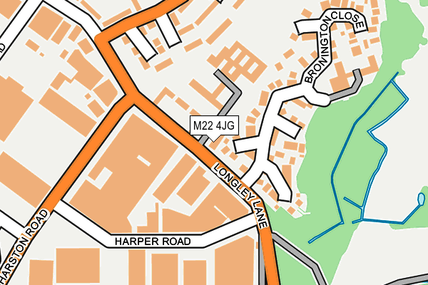
M22 4JG is located in the Northenden electoral ward, within the metropolitan district of Manchester and the English Parliamentary constituency of Wythenshawe and Sale East. The Sub Integrated Care Board (ICB) Location is NHS Greater Manchester ICB - 14L and the police force is Greater Manchester. This postcode has been in use since June 2001.


GetTheData
Source: OS OpenMap – Local (Ordnance Survey)
Source: OS VectorMap District (Ordnance Survey)
Licence: Open Government Licence (requires attribution)
| Easting | 383381 |
| Northing | 389373 |
| Latitude | 53.400916 |
| Longitude | -2.251416 |
GetTheData
Source: Open Postcode Geo
Licence: Open Government Licence
| Country | England |
| Postcode District | M22 |
➜ See where M22 is on a map ➜ Where is Wythenshawe? | |
GetTheData
Source: Land Registry Price Paid Data
Licence: Open Government Licence
Elevation or altitude of M22 4JG as distance above sea level:
| Metres | Feet | |
|---|---|---|
| Elevation | 30m | 98ft |
Elevation is measured from the approximate centre of the postcode, to the nearest point on an OS contour line from OS Terrain 50, which has contour spacing of ten vertical metres.
➜ How high above sea level am I? Find the elevation of your current position using your device's GPS.
GetTheData
Source: Open Postcode Elevation
Licence: Open Government Licence
| Ward | Northenden |
| Constituency | Wythenshawe And Sale East |
GetTheData
Source: ONS Postcode Database
Licence: Open Government Licence
| Harper Rd/Longley Ln (Harper Rd) | Sharston | 129m |
| Sharston Rd/Longley Ln (Sharston Rd) | Sharston | 166m |
| Sharston Rd/Harper Rd (Sharston Rd) | Sharston | 187m |
| Harper Rd/Sharston Rd (Harper Rd) | Sharston | 217m |
| Longley Ln/Harling Rd (Longley Ln) | Northenden | 289m |
| Gatley Station | 1.6km |
| East Didsbury Station | 2.2km |
| Burnage Station | 3.3km |
GetTheData
Source: NaPTAN
Licence: Open Government Licence
GetTheData
Source: ONS Postcode Database
Licence: Open Government Licence


➜ Get more ratings from the Food Standards Agency
GetTheData
Source: Food Standards Agency
Licence: FSA terms & conditions
| Last Collection | |||
|---|---|---|---|
| Location | Mon-Fri | Sat | Distance |
| Longley Lane / Sharston Road | 17:30 | 12:00 | 139m |
| Leestone Road / Longley Lane | 17:30 | 12:00 | 385m |
| In Bus Layby Altrincham Road | 17:30 | 12:00 | 674m |
GetTheData
Source: Dracos
Licence: Creative Commons Attribution-ShareAlike
The below table lists the International Territorial Level (ITL) codes (formerly Nomenclature of Territorial Units for Statistics (NUTS) codes) and Local Administrative Units (LAU) codes for M22 4JG:
| ITL 1 Code | Name |
|---|---|
| TLD | North West (England) |
| ITL 2 Code | Name |
| TLD3 | Greater Manchester |
| ITL 3 Code | Name |
| TLD33 | Manchester |
| LAU 1 Code | Name |
| E08000003 | Manchester |
GetTheData
Source: ONS Postcode Directory
Licence: Open Government Licence
The below table lists the Census Output Area (OA), Lower Layer Super Output Area (LSOA), and Middle Layer Super Output Area (MSOA) for M22 4JG:
| Code | Name | |
|---|---|---|
| OA | E00026689 | |
| LSOA | E01005263 | Manchester 046A |
| MSOA | E02001090 | Manchester 046 |
GetTheData
Source: ONS Postcode Directory
Licence: Open Government Licence
| M22 4LA | Longley Lane | 69m |
| M22 4ZQ | Bronington Close | 88m |
| M22 4LB | Lovett Walk | 136m |
| M22 4LJ | Lovett Walk | 176m |
| M22 4YF | Topcroft Close | 182m |
| M22 4LE | Royle Green Road | 187m |
| M22 4LF | Royle Green Road | 199m |
| M22 4YJ | Kerfoot Close | 208m |
| M22 4LN | Bagnall Walk | 213m |
| M22 4LH | Royle Green Road | 233m |
GetTheData
Source: Open Postcode Geo; Land Registry Price Paid Data
Licence: Open Government Licence