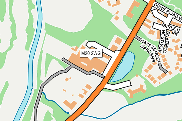
M20 2WG is located in the Didsbury West electoral ward, within the metropolitan district of Manchester and the English Parliamentary constituency of Manchester, Withington. The Sub Integrated Care Board (ICB) Location is NHS Greater Manchester ICB - 14L and the police force is Greater Manchester. This postcode has been in use since May 1994.


GetTheData
Source: OS OpenMap – Local (Ordnance Survey)
Source: OS VectorMap District (Ordnance Survey)
Licence: Open Government Licence (requires attribution)
| Easting | 383699 |
| Northing | 391183 |
| Latitude | 53.417210 |
| Longitude | -2.246727 |
GetTheData
Source: Open Postcode Geo
Licence: Open Government Licence
| Country | England |
| Postcode District | M20 |
➜ See where M20 is on a map ➜ Where is Manchester? | |
GetTheData
Source: Land Registry Price Paid Data
Licence: Open Government Licence
Elevation or altitude of M20 2WG as distance above sea level:
| Metres | Feet | |
|---|---|---|
| Elevation | 30m | 98ft |
Elevation is measured from the approximate centre of the postcode, to the nearest point on an OS contour line from OS Terrain 50, which has contour spacing of ten vertical metres.
➜ How high above sea level am I? Find the elevation of your current position using your device's GPS.
GetTheData
Source: Open Postcode Elevation
Licence: Open Government Licence
| Ward | Didsbury West |
| Constituency | Manchester, Withington |
GetTheData
Source: ONS Postcode Database
Licence: Open Government Licence
2022 29 APR £1,405,000 |
200, PALATINE ROAD, MANCHESTER, M20 2WG 2019 27 JUN £1,150,000 |
2018 10 JUL £970,000 |
196, PALATINE ROAD, MANCHESTER, M20 2WG 2018 30 APR £890,000 |
202, PALATINE ROAD, MANCHESTER, M20 2WG 2017 18 DEC £999,950 |
2017 6 DEC £999,950 |
2016 29 JAN £462,500 |
GetTheData
Source: HM Land Registry Price Paid Data
Licence: Contains HM Land Registry data © Crown copyright and database right 2025. This data is licensed under the Open Government Licence v3.0.
| Palatine Rd/Mersey Rd (Palatine Rd) | Didsbury | 100m |
| Palatine Rd/Friday's (Palatine Rd) | Didsbury | 140m |
| Palatine Rd/Mersey Rd (Palatine Rd) | Didsbury | 152m |
| Palatine Rd/Friday's (Palatine Rd) | Didsbury | 253m |
| Palatine Rd/Withington Golf Club (Palatine Rd) | Didsbury | 322m |
| West Didsbury (Manchester Metrolink) (Lapwing Lane) | West Didsbury | 1,076m |
| Didsbury Village (Manchester Metrolink) (Olive Shapley Avenue) | Didsbury | 1,208m |
| Burton Road (Manchester Metrolink) (Burton Road) | West Didsbury | 1,392m |
| East Didsbury Station | 1.9km |
| Burnage Station | 2.1km |
| Gatley Station | 2.9km |
GetTheData
Source: NaPTAN
Licence: Open Government Licence
| Percentage of properties with Next Generation Access | 100.0% |
| Percentage of properties with Superfast Broadband | 100.0% |
| Percentage of properties with Ultrafast Broadband | 100.0% |
| Percentage of properties with Full Fibre Broadband | 0.0% |
Superfast Broadband is between 30Mbps and 300Mbps
Ultrafast Broadband is > 300Mbps
| Percentage of properties unable to receive 2Mbps | 0.0% |
| Percentage of properties unable to receive 5Mbps | 0.0% |
| Percentage of properties unable to receive 10Mbps | 0.0% |
| Percentage of properties unable to receive 30Mbps | 0.0% |
GetTheData
Source: Ofcom
Licence: Ofcom Terms of Use (requires attribution)
GetTheData
Source: ONS Postcode Database
Licence: Open Government Licence


➜ Get more ratings from the Food Standards Agency
GetTheData
Source: Food Standards Agency
Licence: FSA terms & conditions
| Last Collection | |||
|---|---|---|---|
| Location | Mon-Fri | Sat | Distance |
| Lancaster Road / Spath Road | 17:30 | 12:00 | 448m |
| Barlow Moor Road P.o. | 17:30 | 12:00 | 527m |
| The Beeches | 17:30 | 12:00 | 615m |
GetTheData
Source: Dracos
Licence: Creative Commons Attribution-ShareAlike
The below table lists the International Territorial Level (ITL) codes (formerly Nomenclature of Territorial Units for Statistics (NUTS) codes) and Local Administrative Units (LAU) codes for M20 2WG:
| ITL 1 Code | Name |
|---|---|
| TLD | North West (England) |
| ITL 2 Code | Name |
| TLD3 | Greater Manchester |
| ITL 3 Code | Name |
| TLD33 | Manchester |
| LAU 1 Code | Name |
| E08000003 | Manchester |
GetTheData
Source: ONS Postcode Directory
Licence: Open Government Licence
The below table lists the Census Output Area (OA), Lower Layer Super Output Area (LSOA), and Middle Layer Super Output Area (MSOA) for M20 2WG:
| Code | Name | |
|---|---|---|
| OA | E00025720 | |
| LSOA | E01005078 | Manchester 042B |
| MSOA | E02001086 | Manchester 042 |
GetTheData
Source: ONS Postcode Directory
Licence: Open Government Licence
| M20 2WF | Palatine Road | 81m |
| M20 2YR | Twyford Close | 93m |
| M20 2UF | Palatine Road | 115m |
| M20 2FJ | Samlesbury Close | 116m |
| M20 2GB | Mersey Meadows | 141m |
| M20 2TQ | Adamson Gardens | 168m |
| M20 2TL | Birley Park | 190m |
| M20 2UD | Palatine Road | 228m |
| M20 2TN | Winchester Park | 230m |
| M20 2UL | Larke Rise | 235m |
GetTheData
Source: Open Postcode Geo; Land Registry Price Paid Data
Licence: Open Government Licence