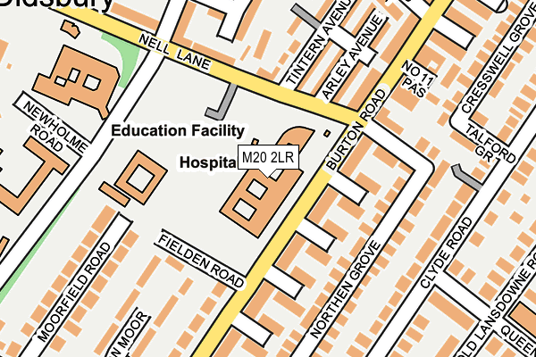
M20 2LR lies on Nell Lane in Manchester. M20 2LR is located in the Didsbury West electoral ward, within the metropolitan district of Manchester and the English Parliamentary constituency of Manchester, Withington. The Sub Integrated Care Board (ICB) Location is NHS Greater Manchester ICB - 14L and the police force is Greater Manchester. This postcode has been in use since June 2008.


GetTheData
Source: OS OpenMap – Local (Ordnance Survey)
Source: OS VectorMap District (Ordnance Survey)
Licence: Open Government Licence (requires attribution)
| Easting | 383801 |
| Northing | 392073 |
| Latitude | 53.425198 |
| Longitude | -2.245239 |
GetTheData
Source: Open Postcode Geo
Licence: Open Government Licence
| Street | Nell Lane |
| Town/City | Manchester |
| Country | England |
| Postcode District | M20 |
➜ See where M20 is on a map ➜ Where is Manchester? | |
GetTheData
Source: Land Registry Price Paid Data
Licence: Open Government Licence
Elevation or altitude of M20 2LR as distance above sea level:
| Metres | Feet | |
|---|---|---|
| Elevation | 30m | 98ft |
Elevation is measured from the approximate centre of the postcode, to the nearest point on an OS contour line from OS Terrain 50, which has contour spacing of ten vertical metres.
➜ How high above sea level am I? Find the elevation of your current position using your device's GPS.
GetTheData
Source: Open Postcode Elevation
Licence: Open Government Licence
| Ward | Didsbury West |
| Constituency | Manchester, Withington |
GetTheData
Source: ONS Postcode Database
Licence: Open Government Licence
| Burton Rd/Withington Community Hosp (Burton Rd) | West Didsbury | 92m |
| Burton Rd/Withington Community Hosp (Burton Road) | West Didsbury | 135m |
| Elizabeth Slinger Rd/Nell Ln (Elizabeth Sl Rd) | West Didsbury | 169m |
| Elizabeth Slinger Rd/Nell Ln (Elizabeth Sl Rd) | West Didsbury | 187m |
| Burton Rd/Barlow Moor Rd (Burton Rd) | West Didsbury | 284m |
| Burton Road (Manchester Metrolink) (Burton Road) | West Didsbury | 536m |
| West Didsbury (Manchester Metrolink) (Lapwing Lane) | West Didsbury | 617m |
| Withington (Manchester Metrolink) (Princess Road) | Withington | 889m |
| Didsbury Village (Manchester Metrolink) (Olive Shapley Avenue) | Didsbury | 1,455m |
| Burnage Station | 2km |
| East Didsbury Station | 2.3km |
| Mauldeth Road Station | 2.5km |
GetTheData
Source: NaPTAN
Licence: Open Government Licence
GetTheData
Source: ONS Postcode Database
Licence: Open Government Licence


➜ Get more ratings from the Food Standards Agency
GetTheData
Source: Food Standards Agency
Licence: FSA terms & conditions
| Last Collection | |||
|---|---|---|---|
| Location | Mon-Fri | Sat | Distance |
| Bottesford Ave / Burton Road | 17:30 | 12:00 | 184m |
| Clyde Road | 17:30 | 12:00 | 208m |
| The Beeches | 17:30 | 12:00 | 317m |
GetTheData
Source: Dracos
Licence: Creative Commons Attribution-ShareAlike
The below table lists the International Territorial Level (ITL) codes (formerly Nomenclature of Territorial Units for Statistics (NUTS) codes) and Local Administrative Units (LAU) codes for M20 2LR:
| ITL 1 Code | Name |
|---|---|
| TLD | North West (England) |
| ITL 2 Code | Name |
| TLD3 | Greater Manchester |
| ITL 3 Code | Name |
| TLD33 | Manchester |
| LAU 1 Code | Name |
| E08000003 | Manchester |
GetTheData
Source: ONS Postcode Directory
Licence: Open Government Licence
The below table lists the Census Output Area (OA), Lower Layer Super Output Area (LSOA), and Middle Layer Super Output Area (MSOA) for M20 2LR:
| Code | Name | |
|---|---|---|
| OA | E00025691 | |
| LSOA | E01005083 | Manchester 039D |
| MSOA | E02001083 | Manchester 039 |
GetTheData
Source: ONS Postcode Directory
Licence: Open Government Licence
| M20 2LZ | Burton Road | 89m |
| M20 2NA | Burton Road | 98m |
| M20 2LJ | Kenilworth Avenue | 100m |
| M20 2LH | Stratford Avenue | 100m |
| M20 2DH | Burton Road | 128m |
| M20 2LL | Warwick Avenue | 137m |
| M20 2LG | Nell Lane | 138m |
| M20 2WL | Northen Grove | 143m |
| M20 2LQ | Arley Avenue | 158m |
| M20 2LE | Tintern Avenue | 160m |
GetTheData
Source: Open Postcode Geo; Land Registry Price Paid Data
Licence: Open Government Licence