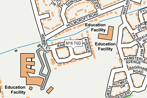
M18 7GD lies on Fallow Avenue in Manchester. M18 7GD is located in the Longsight electoral ward, within the metropolitan district of Manchester and the English Parliamentary constituency of Manchester, Gorton. The Sub Integrated Care Board (ICB) Location is NHS Greater Manchester ICB - 14L and the police force is Greater Manchester. This postcode has been in use since July 2006.


GetTheData
Source: OS OpenMap – Local (Ordnance Survey)
Source: OS VectorMap District (Ordnance Survey)
Licence: Open Government Licence (requires attribution)
| Easting | 388671 |
| Northing | 394931 |
| Latitude | 53.451015 |
| Longitude | -2.172056 |
GetTheData
Source: Open Postcode Geo
Licence: Open Government Licence
| Street | Fallow Avenue |
| Town/City | Manchester |
| Country | England |
| Postcode District | M18 |
➜ See where M18 is on a map ➜ Where is Manchester? | |
GetTheData
Source: Land Registry Price Paid Data
Licence: Open Government Licence
Elevation or altitude of M18 7GD as distance above sea level:
| Metres | Feet | |
|---|---|---|
| Elevation | 70m | 230ft |
Elevation is measured from the approximate centre of the postcode, to the nearest point on an OS contour line from OS Terrain 50, which has contour spacing of ten vertical metres.
➜ How high above sea level am I? Find the elevation of your current position using your device's GPS.
GetTheData
Source: Open Postcode Elevation
Licence: Open Government Licence
| Ward | Longsight |
| Constituency | Manchester, Gorton |
GetTheData
Source: ONS Postcode Database
Licence: Open Government Licence
| St Peters R.c. Lower School (Holmcroft Rd) | Ryder Brow | 108m |
| Holmcroft Rd/Sandown Cres (Holmcroft Rd) | Ryder Brow | 121m |
| Wembley Rd/Melland Sch (Wembley Rd) | Ryder Brow | 170m |
| Holmcroft Rd/Sandown Cres (Holmcroft Rd) | Ryder Brow | 181m |
| Wembley Rd/Harlow Dr (Wembley Rd) | Ryder Brow | 228m |
| Ryder Brow Station | 0.6km |
| Reddish North Station | 1.1km |
| Belle Vue Station | 1.4km |
GetTheData
Source: NaPTAN
Licence: Open Government Licence
| Percentage of properties with Next Generation Access | 100.0% |
| Percentage of properties with Superfast Broadband | 100.0% |
| Percentage of properties with Ultrafast Broadband | 0.0% |
| Percentage of properties with Full Fibre Broadband | 0.0% |
Superfast Broadband is between 30Mbps and 300Mbps
Ultrafast Broadband is > 300Mbps
| Percentage of properties unable to receive 2Mbps | 0.0% |
| Percentage of properties unable to receive 5Mbps | 0.0% |
| Percentage of properties unable to receive 10Mbps | 0.0% |
| Percentage of properties unable to receive 30Mbps | 0.0% |
GetTheData
Source: Ofcom
Licence: Ofcom Terms of Use (requires attribution)
GetTheData
Source: ONS Postcode Database
Licence: Open Government Licence


➜ Get more ratings from the Food Standards Agency
GetTheData
Source: Food Standards Agency
Licence: FSA terms & conditions
| Last Collection | |||
|---|---|---|---|
| Location | Mon-Fri | Sat | Distance |
| 53 Hemworth Road | 17:30 | 12:00 | 338m |
| Darras Avenue | 17:30 | 12:00 | 541m |
| Marquis Street | 17:30 | 12:00 | 601m |
GetTheData
Source: Dracos
Licence: Creative Commons Attribution-ShareAlike
The below table lists the International Territorial Level (ITL) codes (formerly Nomenclature of Territorial Units for Statistics (NUTS) codes) and Local Administrative Units (LAU) codes for M18 7GD:
| ITL 1 Code | Name |
|---|---|
| TLD | North West (England) |
| ITL 2 Code | Name |
| TLD3 | Greater Manchester |
| ITL 3 Code | Name |
| TLD33 | Manchester |
| LAU 1 Code | Name |
| E08000003 | Manchester |
GetTheData
Source: ONS Postcode Directory
Licence: Open Government Licence
The below table lists the Census Output Area (OA), Lower Layer Super Output Area (LSOA), and Middle Layer Super Output Area (MSOA) for M18 7GD:
| Code | Name | |
|---|---|---|
| OA | E00175924 | |
| LSOA | E01005196 | Manchester 023B |
| MSOA | E02001067 | Manchester 023 |
GetTheData
Source: ONS Postcode Directory
Licence: Open Government Licence
| M18 7GB | Rawsthorne Avenue | 31m |
| M18 7GA | Rawsthorne Avenue | 51m |
| M18 7NG | Holmcroft Road | 117m |
| M18 7WQ | Holmcroft Road | 162m |
| M18 7WG | Sandown Crescent | 184m |
| M18 7TR | Flemish Crescent | 209m |
| M18 7TN | Shillingford Road | 211m |
| M18 7TJ | Braithwaite Road | 219m |
| M18 7NR | Westlea Drive | 229m |
| M18 7TG | Falshaw Way | 244m |
GetTheData
Source: Open Postcode Geo; Land Registry Price Paid Data
Licence: Open Government Licence