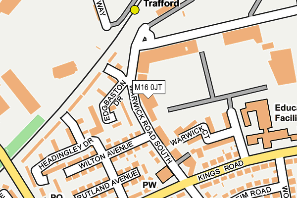
M16 0JT is located in the Longford electoral ward, within the metropolitan district of Trafford and the English Parliamentary constituency of Stretford and Urmston. The Sub Integrated Care Board (ICB) Location is NHS Greater Manchester ICB - 02A and the police force is Greater Manchester. This postcode has been in use since January 1980.


GetTheData
Source: OS OpenMap – Local (Ordnance Survey)
Source: OS VectorMap District (Ordnance Survey)
Licence: Open Government Licence (requires attribution)
| Easting | 381246 |
| Northing | 395402 |
| Latitude | 53.455035 |
| Longitude | -2.283887 |
GetTheData
Source: Open Postcode Geo
Licence: Open Government Licence
| Country | England |
| Postcode District | M16 |
➜ See where M16 is on a map ➜ Where is Old Trafford? | |
GetTheData
Source: Land Registry Price Paid Data
Licence: Open Government Licence
Elevation or altitude of M16 0JT as distance above sea level:
| Metres | Feet | |
|---|---|---|
| Elevation | 30m | 98ft |
Elevation is measured from the approximate centre of the postcode, to the nearest point on an OS contour line from OS Terrain 50, which has contour spacing of ten vertical metres.
➜ How high above sea level am I? Find the elevation of your current position using your device's GPS.
GetTheData
Source: Open Postcode Elevation
Licence: Open Government Licence
| Ward | Longford |
| Constituency | Stretford And Urmston |
GetTheData
Source: ONS Postcode Database
Licence: Open Government Licence
| Kings Road/Warwick Road South (Kings Road) | Firswood | 183m |
| Kings Road/Warwick Road South (Kings Road) | Firswood | 203m |
| Kings Road/Woodstock Road (Kings Road) | Firswood | 286m |
| The Quadrant/Greatstone Road (The Quadrant) | Firswood | 291m |
| Greatstone Road/B & Q (Greatstone Road) | Gorse Hill | 340m |
| Old Trafford (Manchester Metrolink) (Trafford Park Road) | Old Trafford | 162m |
| Firswood Station (Manchester Metrolink) (Rye Bank Road) | Firswood | 586m |
| Trafford Bar (Manchester Metrolink) (Seymour Grove) | Trafford Bar | 902m |
| Pomona (Manchester Metrolink) (Pomona Strand) | Salford Quays | 1,183m |
| Exchange Quay (Manchester Metrolink) (Exchange Quay) | Salford Quays | 1,357m |
| Manchester United FC Station | 0.9km |
| Trafford Park Station | 1.8km |
| Humphrey Park Station | 2.9km |
GetTheData
Source: NaPTAN
Licence: Open Government Licence
Estimated total energy consumption in M16 0JT by fuel type, 2015.
| Consumption (kWh) | 387,385 |
|---|---|
| Meter count | 60 |
| Mean (kWh/meter) | 6,456 |
| Median (kWh/meter) | 6,456 |
GetTheData
Source: Postcode level gas estimates: 2015 (experimental)
Source: Postcode level electricity estimates: 2015 (experimental)
Licence: Open Government Licence
GetTheData
Source: ONS Postcode Database
Licence: Open Government Licence


➜ Get more ratings from the Food Standards Agency
GetTheData
Source: Food Standards Agency
Licence: FSA terms & conditions
| Last Collection | |||
|---|---|---|---|
| Location | Mon-Fri | Sat | Distance |
| Greatstone Road P.o. | 17:30 | 12:00 | 310m |
| 94 Warick Road South | 17:30 | 12:00 | 447m |
| Talbot Road | 17:30 | 12:00 | 574m |
GetTheData
Source: Dracos
Licence: Creative Commons Attribution-ShareAlike
The below table lists the International Territorial Level (ITL) codes (formerly Nomenclature of Territorial Units for Statistics (NUTS) codes) and Local Administrative Units (LAU) codes for M16 0JT:
| ITL 1 Code | Name |
|---|---|
| TLD | North West (England) |
| ITL 2 Code | Name |
| TLD3 | Greater Manchester |
| ITL 3 Code | Name |
| TLD34 | Greater Manchester South West |
| LAU 1 Code | Name |
| E08000009 | Trafford |
GetTheData
Source: ONS Postcode Directory
Licence: Open Government Licence
The below table lists the Census Output Area (OA), Lower Layer Super Output Area (LSOA), and Middle Layer Super Output Area (MSOA) for M16 0JT:
| Code | Name | |
|---|---|---|
| OA | E00031118 | |
| LSOA | E01006145 | Trafford 004D |
| MSOA | E02001262 | Trafford 004 |
GetTheData
Source: ONS Postcode Directory
Licence: Open Government Licence
| M16 0GZ | Warwick Road South | 53m |
| M16 9AL | Warwick Road South | 64m |
| M16 0JG | Warwick Court | 144m |
| M16 0JH | Wilton Avenue | 166m |
| M16 0JF | Rutland Avenue | 181m |
| M16 0JE | Kings Road | 189m |
| M16 0GR | Kings Road | 191m |
| M16 0JR | Trent Bridge Walk | 193m |
| M16 0JP | Headingley Drive | 213m |
| M16 0JD | Kings Road | 221m |
GetTheData
Source: Open Postcode Geo; Land Registry Price Paid Data
Licence: Open Government Licence