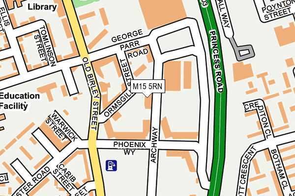
M15 5RN is located in the Hulme electoral ward, within the metropolitan district of Manchester and the English Parliamentary constituency of Manchester Central. The Sub Integrated Care Board (ICB) Location is NHS Greater Manchester ICB - 14L and the police force is Greater Manchester. This postcode has been in use since June 2001.


GetTheData
Source: OS OpenMap – Local (Ordnance Survey)
Source: OS VectorMap District (Ordnance Survey)
Licence: Open Government Licence (requires attribution)
| Easting | 383708 |
| Northing | 396507 |
| Latitude | 53.465050 |
| Longitude | -2.246870 |
GetTheData
Source: Open Postcode Geo
Licence: Open Government Licence
| Country | England |
| Postcode District | M15 |
➜ See where M15 is on a map ➜ Where is Manchester? | |
GetTheData
Source: Land Registry Price Paid Data
Licence: Open Government Licence
Elevation or altitude of M15 5RN as distance above sea level:
| Metres | Feet | |
|---|---|---|
| Elevation | 30m | 98ft |
Elevation is measured from the approximate centre of the postcode, to the nearest point on an OS contour line from OS Terrain 50, which has contour spacing of ten vertical metres.
➜ How high above sea level am I? Find the elevation of your current position using your device's GPS.
GetTheData
Source: Open Postcode Elevation
Licence: Open Government Licence
| Ward | Hulme |
| Constituency | Manchester Central |
GetTheData
Source: ONS Postcode Database
Licence: Open Government Licence
| Old Birley St/Nia Centre (Old Birley St) | Hulme | 113m |
| Old Birley St/Nia Centre (Old Birley St) | Hulme | 150m |
| Greenheys Ln West/Asda (Greenheys Ln W) | Hulme | 247m |
| Greenheys Ln West/Asda (Greenheys Ln W) | Hulme | 270m |
| Princess Rd/Westerley Slip Rd (Princess P'way) | Hulme | 278m |
| Deansgate-castlefield (Manchester Metrolink) (Whitworth Street West) | Manchester City Centre | 1,119m |
| Cornbrook (Manchester Metrolink) | Cornbrook | 1,481m |
| St Peters Square (Manchester Metrolink) (Peter Street) | Manchester City Centre | 1,484m |
| Piccadilly (Manchester Metrolink) (London Road) | Manchester City Centre | 1,697m |
| Manchester Oxford Road Station | 1.1km |
| Deansgate Station | 1.1km |
| Manchester Piccadilly Station | 1.7km |
GetTheData
Source: NaPTAN
Licence: Open Government Licence
GetTheData
Source: ONS Postcode Database
Licence: Open Government Licence


➜ Get more ratings from the Food Standards Agency
GetTheData
Source: Food Standards Agency
Licence: FSA terms & conditions
| Last Collection | |||
|---|---|---|---|
| Location | Mon-Fri | Sat | Distance |
| Hulme P.o. | 17:30 | 12:00 | 312m |
| Brennan Close Arnott Cresent | 17:30 | 12:00 | 328m |
| Woodcock Square | 17:30 | 12:00 | 396m |
GetTheData
Source: Dracos
Licence: Creative Commons Attribution-ShareAlike
The below table lists the International Territorial Level (ITL) codes (formerly Nomenclature of Territorial Units for Statistics (NUTS) codes) and Local Administrative Units (LAU) codes for M15 5RN:
| ITL 1 Code | Name |
|---|---|
| TLD | North West (England) |
| ITL 2 Code | Name |
| TLD3 | Greater Manchester |
| ITL 3 Code | Name |
| TLD33 | Manchester |
| LAU 1 Code | Name |
| E08000003 | Manchester |
GetTheData
Source: ONS Postcode Directory
Licence: Open Government Licence
The below table lists the Census Output Area (OA), Lower Layer Super Output Area (LSOA), and Middle Layer Super Output Area (MSOA) for M15 5RN:
| Code | Name | |
|---|---|---|
| OA | E00175826 | |
| LSOA | E01005208 | Manchester 019A |
| MSOA | E02001063 | Manchester 019 |
GetTheData
Source: ONS Postcode Directory
Licence: Open Government Licence
| M15 5RG | Old Birley Street | 209m |
| M15 5FW | Tomlinson Street | 236m |
| M15 6FY | Pinder Walk | 239m |
| M15 6WJ | Peatfield Walk | 260m |
| M15 5EL | Academy Walk | 274m |
| M15 5FX | Dunham Street | 276m |
| M15 6EG | Wasnidge Walk | 288m |
| M15 5JR | Hulme High Street | 289m |
| M15 4UW | Stretford Road | 295m |
| M15 5AY | Boston Street | 304m |
GetTheData
Source: Open Postcode Geo; Land Registry Price Paid Data
Licence: Open Government Licence