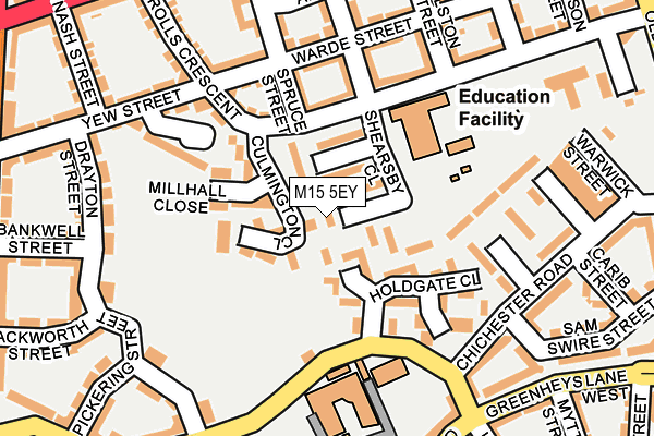
M15 5EY is located in the Hulme electoral ward, within the metropolitan district of Manchester and the English Parliamentary constituency of Manchester Central. The Sub Integrated Care Board (ICB) Location is NHS Greater Manchester ICB - 14L and the police force is Greater Manchester. This postcode has been in use since May 1994.


GetTheData
Source: OS OpenMap – Local (Ordnance Survey)
Source: OS VectorMap District (Ordnance Survey)
Licence: Open Government Licence (requires attribution)
| Easting | 383284 |
| Northing | 396400 |
| Latitude | 53.464074 |
| Longitude | -2.253251 |
GetTheData
Source: Open Postcode Geo
Licence: Open Government Licence
| Country | England |
| Postcode District | M15 |
➜ See where M15 is on a map ➜ Where is Manchester? | |
GetTheData
Source: Land Registry Price Paid Data
Licence: Open Government Licence
Elevation or altitude of M15 5EY as distance above sea level:
| Metres | Feet | |
|---|---|---|
| Elevation | 30m | 98ft |
Elevation is measured from the approximate centre of the postcode, to the nearest point on an OS contour line from OS Terrain 50, which has contour spacing of ten vertical metres.
➜ How high above sea level am I? Find the elevation of your current position using your device's GPS.
GetTheData
Source: Open Postcode Elevation
Licence: Open Government Licence
| Ward | Hulme |
| Constituency | Manchester Central |
GetTheData
Source: ONS Postcode Database
Licence: Open Government Licence
| Rolls Cres/Spruce St (Rolls Cres) | Hulme | 103m |
| Greenheys Ln West/Old Birley St (Greenheys Ln W) | Hulme | 255m |
| Chichester Rd/Loreto College (Greenheys Ln) | Hulme | 272m |
| Stretford Rd/Mallow St (Stretford Rd) | Hulme | 275m |
| Stretford Rd/Chorlton Rd (Stretford Rd) | Hulme | 292m |
| Cornbrook (Manchester Metrolink) | Cornbrook | 1,155m |
| Deansgate-castlefield (Manchester Metrolink) (Whitworth Street West) | Manchester City Centre | 1,194m |
| Piccadilly (Manchester Metrolink) (London Road) | Manchester City Centre | 2,056m |
| Deansgate Station | 1.1km |
| Manchester Oxford Road Station | 1.3km |
| Manchester Piccadilly Station | 2.1km |
GetTheData
Source: NaPTAN
Licence: Open Government Licence
| Percentage of properties with Next Generation Access | 0.0% |
| Percentage of properties with Superfast Broadband | 0.0% |
| Percentage of properties with Ultrafast Broadband | 0.0% |
| Percentage of properties with Full Fibre Broadband | 0.0% |
Superfast Broadband is between 30Mbps and 300Mbps
Ultrafast Broadband is > 300Mbps
| Percentage of properties unable to receive 2Mbps | 0.0% |
| Percentage of properties unable to receive 5Mbps | 0.0% |
| Percentage of properties unable to receive 10Mbps | 0.0% |
| Percentage of properties unable to receive 30Mbps | 100.0% |
GetTheData
Source: Ofcom
Licence: Ofcom Terms of Use (requires attribution)
GetTheData
Source: ONS Postcode Database
Licence: Open Government Licence


➜ Get more ratings from the Food Standards Agency
GetTheData
Source: Food Standards Agency
Licence: FSA terms & conditions
| Last Collection | |||
|---|---|---|---|
| Location | Mon-Fri | Sat | Distance |
| Chichester Road | 17:30 | 11:45 | 161m |
| Hulme P.o. | 17:30 | 12:00 | 477m |
| Brooks Bar | 17:30 | 11:45 | 645m |
GetTheData
Source: Dracos
Licence: Creative Commons Attribution-ShareAlike
The below table lists the International Territorial Level (ITL) codes (formerly Nomenclature of Territorial Units for Statistics (NUTS) codes) and Local Administrative Units (LAU) codes for M15 5EY:
| ITL 1 Code | Name |
|---|---|
| TLD | North West (England) |
| ITL 2 Code | Name |
| TLD3 | Greater Manchester |
| ITL 3 Code | Name |
| TLD33 | Manchester |
| LAU 1 Code | Name |
| E08000003 | Manchester |
GetTheData
Source: ONS Postcode Directory
Licence: Open Government Licence
The below table lists the Census Output Area (OA), Lower Layer Super Output Area (LSOA), and Middle Layer Super Output Area (MSOA) for M15 5EY:
| Code | Name | |
|---|---|---|
| OA | E00026398 | |
| LSOA | E01005208 | Manchester 019A |
| MSOA | E02001063 | Manchester 019 |
GetTheData
Source: ONS Postcode Directory
Licence: Open Government Licence
| M15 5ET | Denbigh Walk | 38m |
| M15 5EW | Alliott Walk | 59m |
| M15 5HR | Culmington Close | 64m |
| M15 5FT | Rolls Crescent | 65m |
| M15 5DY | Millhalf Close | 86m |
| M15 5EP | Holdgate Close | 106m |
| M15 5TB | Spruce Street | 117m |
| M15 5EN | Alanbrooke Walk | 154m |
| M15 5RP | Sadler Court | 155m |
| M15 5TF | Warde Street | 160m |
GetTheData
Source: Open Postcode Geo; Land Registry Price Paid Data
Licence: Open Government Licence