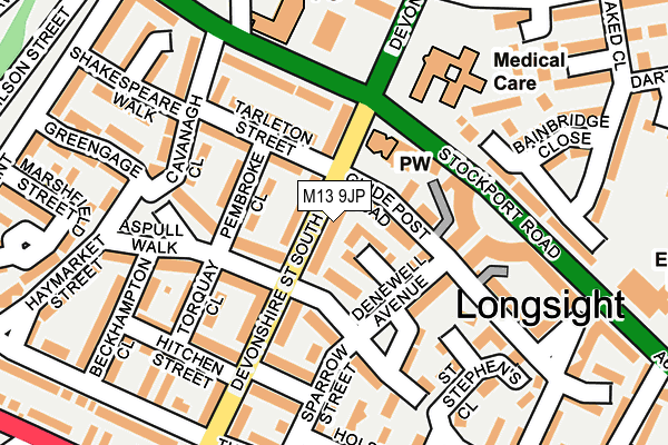
M13 9JP lies on Devonshire Street South in Manchester. M13 9JP is located in the Ardwick electoral ward, within the metropolitan district of Manchester and the English Parliamentary constituency of Manchester Central. The Sub Integrated Care Board (ICB) Location is NHS Greater Manchester ICB - 14L and the police force is Greater Manchester. This postcode has been in use since July 2010.


GetTheData
Source: OS OpenMap – Local (Ordnance Survey)
Source: OS VectorMap District (Ordnance Survey)
Licence: Open Government Licence (requires attribution)
| Easting | 385642 |
| Northing | 396574 |
| Latitude | 53.465709 |
| Longitude | -2.217742 |
GetTheData
Source: Open Postcode Geo
Licence: Open Government Licence
| Street | Devonshire Street South |
| Town/City | Manchester |
| Country | England |
| Postcode District | M13 |
➜ See where M13 is on a map ➜ Where is Manchester? | |
GetTheData
Source: Land Registry Price Paid Data
Licence: Open Government Licence
Elevation or altitude of M13 9JP as distance above sea level:
| Metres | Feet | |
|---|---|---|
| Elevation | 40m | 131ft |
Elevation is measured from the approximate centre of the postcode, to the nearest point on an OS contour line from OS Terrain 50, which has contour spacing of ten vertical metres.
➜ How high above sea level am I? Find the elevation of your current position using your device's GPS.
GetTheData
Source: Open Postcode Elevation
Licence: Open Government Licence
| Ward | Ardwick |
| Constituency | Manchester Central |
GetTheData
Source: ONS Postcode Database
Licence: Open Government Licence
| Devonshire St South (Devonshire St S) | Chorlton Upon Medlock | 81m |
| Stockport Rd/Devonshire St (Stockport Rd) | Ardwick | 125m |
| Stockport Rd/Devonshire St (Stockport Rd) | Ardwick | 178m |
| Stockport Rd/Ardwick P.o. (Stockport Rd) | Ardwick | 179m |
| Stockport Rd/Cavanagh Cl (Stockport Rd) | Brunswick | 234m |
| Piccadilly (Manchester Metrolink) (London Road) | Manchester City Centre | 1,584m |
| Ardwick Station | 0.7km |
| Manchester Piccadilly Station | 1.6km |
| Ashburys Station | 1.7km |
GetTheData
Source: NaPTAN
Licence: Open Government Licence
| Percentage of properties with Next Generation Access | 100.0% |
| Percentage of properties with Superfast Broadband | 100.0% |
| Percentage of properties with Ultrafast Broadband | 100.0% |
| Percentage of properties with Full Fibre Broadband | 100.0% |
Superfast Broadband is between 30Mbps and 300Mbps
Ultrafast Broadband is > 300Mbps
| Median download speed | 18.1Mbps |
| Average download speed | 17.4Mbps |
| Maximum download speed | 19.99Mbps |
| Median upload speed | 1.2Mbps |
| Average upload speed | 1.1Mbps |
| Maximum upload speed | 1.23Mbps |
| Percentage of properties unable to receive 2Mbps | 0.0% |
| Percentage of properties unable to receive 5Mbps | 0.0% |
| Percentage of properties unable to receive 10Mbps | 0.0% |
| Percentage of properties unable to receive 30Mbps | 0.0% |
GetTheData
Source: Ofcom
Licence: Ofcom Terms of Use (requires attribution)
Estimated total energy consumption in M13 9JP by fuel type, 2015.
| Consumption (kWh) | 210,929 |
|---|---|
| Meter count | 25 |
| Mean (kWh/meter) | 8,437 |
| Median (kWh/meter) | 8,236 |
| Consumption (kWh) | 28,021 |
|---|---|
| Meter count | 16 |
| Mean (kWh/meter) | 1,751 |
| Median (kWh/meter) | 1,568 |
GetTheData
Source: Postcode level gas estimates: 2015 (experimental)
Source: Postcode level electricity estimates: 2015 (experimental)
Licence: Open Government Licence
GetTheData
Source: ONS Postcode Database
Licence: Open Government Licence


➜ Get more ratings from the Food Standards Agency
GetTheData
Source: Food Standards Agency
Licence: FSA terms & conditions
| Last Collection | |||
|---|---|---|---|
| Location | Mon-Fri | Sat | Distance |
| Devonshire Street South | 17:30 | 12:00 | 65m |
| Stockport Road P.o. | 18:00 | 12:00 | 176m |
| Gold Cup Public House | 17:30 | 12:00 | 416m |
GetTheData
Source: Dracos
Licence: Creative Commons Attribution-ShareAlike
The below table lists the International Territorial Level (ITL) codes (formerly Nomenclature of Territorial Units for Statistics (NUTS) codes) and Local Administrative Units (LAU) codes for M13 9JP:
| ITL 1 Code | Name |
|---|---|
| TLD | North West (England) |
| ITL 2 Code | Name |
| TLD3 | Greater Manchester |
| ITL 3 Code | Name |
| TLD33 | Manchester |
| LAU 1 Code | Name |
| E08000003 | Manchester |
GetTheData
Source: ONS Postcode Directory
Licence: Open Government Licence
The below table lists the Census Output Area (OA), Lower Layer Super Output Area (LSOA), and Middle Layer Super Output Area (MSOA) for M13 9JP:
| Code | Name | |
|---|---|---|
| OA | E00025629 | |
| LSOA | E01005062 | Manchester 018B |
| MSOA | E02001062 | Manchester 018 |
GetTheData
Source: ONS Postcode Directory
Licence: Open Government Licence
| M13 9HY | Devonshire Street South | 36m |
| M13 9JQ | Devonshire Street South | 44m |
| M13 9JH | Guide Post Road | 44m |
| M13 9DY | Pembroke Close | 68m |
| M13 9AE | Markfield Avenue | 73m |
| M13 9GE | Denewell Avenue | 105m |
| M13 9BS | Tarleton Street | 113m |
| M13 9AB | Stockport Road | 126m |
| M13 9GX | Hatchley Street | 134m |
| M13 9DJ | Torquay Close | 138m |
GetTheData
Source: Open Postcode Geo; Land Registry Price Paid Data
Licence: Open Government Licence