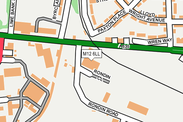
M12 6LL is located in the Ardwick electoral ward, within the metropolitan district of Manchester and the English Parliamentary constituency of Manchester Central. The Sub Integrated Care Board (ICB) Location is NHS Greater Manchester ICB - 14L and the police force is Greater Manchester. This postcode has been in use since June 2002.


GetTheData
Source: OS OpenMap – Local (Ordnance Survey)
Source: OS VectorMap District (Ordnance Survey)
Licence: Open Government Licence (requires attribution)
| Easting | 386108 |
| Northing | 397590 |
| Latitude | 53.474869 |
| Longitude | -2.210766 |
GetTheData
Source: Open Postcode Geo
Licence: Open Government Licence
| Country | England |
| Postcode District | M12 |
➜ See where M12 is on a map ➜ Where is Manchester? | |
GetTheData
Source: Land Registry Price Paid Data
Licence: Open Government Licence
Elevation or altitude of M12 6LL as distance above sea level:
| Metres | Feet | |
|---|---|---|
| Elevation | 50m | 164ft |
Elevation is measured from the approximate centre of the postcode, to the nearest point on an OS contour line from OS Terrain 50, which has contour spacing of ten vertical metres.
➜ How high above sea level am I? Find the elevation of your current position using your device's GPS.
GetTheData
Source: Open Postcode Elevation
Licence: Open Government Licence
| Ward | Ardwick |
| Constituency | Manchester Central |
GetTheData
Source: ONS Postcode Database
Licence: Open Government Licence
| Ashton Old Rd/Rondin Rd (Ashton Old Rd) | Ardwick | 22m |
| Ashton Old Rd/Rondin Rd (Ashton Old Rd) | Ardwick | 55m |
| Ashton Old Rd/Claribel St (Ashton Old Rd) | Ardwick | 95m |
| Markham Cl/Viaduct St (Markham Cl) | Ancoats | 195m |
| Ashton Old Rd/Gorton Rd (Ashton Old Rd) | Ardwick | 198m |
| New Islington (Manchester Metrolink) (Pollard Street) | New Islington | 914m |
| Holt Town (Manchester Metrolink) (Holt Town) | Holt Town | 934m |
| Etihad Campus (Manchester Metrolink) (Joe Mercer Way) | Sportcity | 1,326m |
| Piccadilly (Manchester Metrolink) (London Road) | Manchester City Centre | 1,410m |
| Velopark (Manchester Metrolink) (Ashton New Road) | Sportcity | 1,438m |
| Ardwick Station | 0.4km |
| Ashburys Station | 1.1km |
| Manchester Piccadilly Station | 1.4km |
GetTheData
Source: NaPTAN
Licence: Open Government Licence
GetTheData
Source: ONS Postcode Database
Licence: Open Government Licence

➜ Get more ratings from the Food Standards Agency
GetTheData
Source: Food Standards Agency
Licence: FSA terms & conditions
| Last Collection | |||
|---|---|---|---|
| Location | Mon-Fri | Sat | Distance |
| Outside 230 Viaduct Street | 17:30 | 12:00 | 300m |
| Whixall Close | 17:30 | 12:00 | 684m |
| Every Street | 19:00 | 12:00 | 745m |
GetTheData
Source: Dracos
Licence: Creative Commons Attribution-ShareAlike
The below table lists the International Territorial Level (ITL) codes (formerly Nomenclature of Territorial Units for Statistics (NUTS) codes) and Local Administrative Units (LAU) codes for M12 6LL:
| ITL 1 Code | Name |
|---|---|
| TLD | North West (England) |
| ITL 2 Code | Name |
| TLD3 | Greater Manchester |
| ITL 3 Code | Name |
| TLD33 | Manchester |
| LAU 1 Code | Name |
| E08000003 | Manchester |
GetTheData
Source: ONS Postcode Directory
Licence: Open Government Licence
The below table lists the Census Output Area (OA), Lower Layer Super Output Area (LSOA), and Middle Layer Super Output Area (MSOA) for M12 6LL:
| Code | Name | |
|---|---|---|
| OA | E00025605 | |
| LSOA | E01005061 | Manchester 018A |
| MSOA | E02001062 | Manchester 018 |
GetTheData
Source: ONS Postcode Directory
Licence: Open Government Licence
| M12 6LE | Ashton Old Road | 61m |
| M12 6NE | Viaduct Street | 147m |
| M11 3NL | Paxton Place | 162m |
| M11 3BH | Olympic Street | 202m |
| M12 6WR | Markham Close | 228m |
| M11 3BN | Holly Street | 230m |
| M11 3NJ | Lloyd Wright Avenue | 239m |
| M11 3NH | Wren Way | 257m |
| M12 6LB | Midland Street | 258m |
| M11 3NT | Paxton Place | 267m |
GetTheData
Source: Open Postcode Geo; Land Registry Price Paid Data
Licence: Open Government Licence