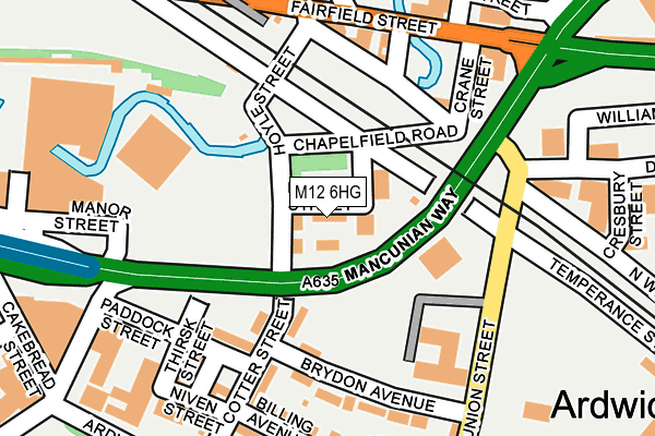
M12 6HG is located in the Piccadilly electoral ward, within the metropolitan district of Manchester and the English Parliamentary constituency of Manchester Central. The Sub Integrated Care Board (ICB) Location is NHS Greater Manchester ICB - 14L and the police force is Greater Manchester. This postcode has been in use since January 1980.


GetTheData
Source: OS OpenMap – Local (Ordnance Survey)
Source: OS VectorMap District (Ordnance Survey)
Licence: Open Government Licence (requires attribution)
| Easting | 385327 |
| Northing | 397495 |
| Latitude | 53.473978 |
| Longitude | -2.222530 |
GetTheData
Source: Open Postcode Geo
Licence: Open Government Licence
| Country | England |
| Postcode District | M12 |
➜ See where M12 is on a map ➜ Where is Manchester? | |
GetTheData
Source: Land Registry Price Paid Data
Licence: Open Government Licence
Elevation or altitude of M12 6HG as distance above sea level:
| Metres | Feet | |
|---|---|---|
| Elevation | 40m | 131ft |
Elevation is measured from the approximate centre of the postcode, to the nearest point on an OS contour line from OS Terrain 50, which has contour spacing of ten vertical metres.
➜ How high above sea level am I? Find the elevation of your current position using your device's GPS.
GetTheData
Source: Open Postcode Elevation
Licence: Open Government Licence
| Ward | Piccadilly |
| Constituency | Manchester Central |
GetTheData
Source: ONS Postcode Database
Licence: Open Government Licence
| Fairfield St/Mancunian Way (Fairfield St) | Ardwick | 191m |
| Fairfield St/Mancunian Way (Fairfield St) | Ardwick | 209m |
| Ardwick Green Sth/Ardwick Green (Ardwick Grn Sth) | Ardwick | 348m |
| Ardwick Green Sth/Ardwick Green (Ardwick Grn Sth) | Ardwick | 353m |
| Pin Mill Brow/Ashton Old Rd (Pin Mill Brow) | Ardwick | 382m |
| Piccadilly (Manchester Metrolink) (London Road) | Manchester City Centre | 707m |
| New Islington (Manchester Metrolink) (Pollard Street) | New Islington | 809m |
| Piccadilly Gardens (Manchester Metrolink) (Portland Street) | Piccadilly Gardens | 1,150m |
| Holt Town (Manchester Metrolink) (Holt Town) | Holt Town | 1,234m |
| Market Street (Manchester Metrolink) (Market Street) | Manchester City Centre | 1,413m |
| Ardwick Station | 0.6km |
| Manchester Piccadilly Station | 0.7km |
| Manchester Oxford Road Station | 1.3km |
GetTheData
Source: NaPTAN
Licence: Open Government Licence
| Median download speed | 26.1Mbps |
| Average download speed | 23.4Mbps |
| Maximum download speed | 34.08Mbps |
| Median upload speed | 3.8Mbps |
| Average upload speed | 3.8Mbps |
| Maximum upload speed | 7.67Mbps |
GetTheData
Source: Ofcom
Licence: Ofcom Terms of Use (requires attribution)
GetTheData
Source: ONS Postcode Database
Licence: Open Government Licence


➜ Get more ratings from the Food Standards Agency
GetTheData
Source: Food Standards Agency
Licence: FSA terms & conditions
| Last Collection | |||
|---|---|---|---|
| Location | Mon-Fri | Sat | Distance |
| Fairfield Street/ | 19:00 | 12:00 | 221m |
| St Thomas | 17:30 | 12:00 | 260m |
| Brunswich Street | 17:30 | 12:00 | 546m |
GetTheData
Source: Dracos
Licence: Creative Commons Attribution-ShareAlike
The below table lists the International Territorial Level (ITL) codes (formerly Nomenclature of Territorial Units for Statistics (NUTS) codes) and Local Administrative Units (LAU) codes for M12 6HG:
| ITL 1 Code | Name |
|---|---|
| TLD | North West (England) |
| ITL 2 Code | Name |
| TLD3 | Greater Manchester |
| ITL 3 Code | Name |
| TLD33 | Manchester |
| LAU 1 Code | Name |
| E08000003 | Manchester |
GetTheData
Source: ONS Postcode Directory
Licence: Open Government Licence
The below table lists the Census Output Area (OA), Lower Layer Super Output Area (LSOA), and Middle Layer Super Output Area (MSOA) for M12 6HG:
| Code | Name | |
|---|---|---|
| OA | E00176089 | |
| LSOA | E01033661 | Manchester 055E |
| MSOA | E02006912 | Manchester 055 |
GetTheData
Source: ONS Postcode Directory
Licence: Open Government Licence
| M12 6JA | Brydon Avenue | 122m |
| M12 6EY | Cotter Street | 151m |
| M12 6EZ | Billing Avenue | 186m |
| M12 6EL | Fairfield Street | 210m |
| M12 6FS | Durling Street | 236m |
| M12 6HE | Manor Street | 251m |
| M12 6ER | Ardwick Green North | 255m |
| M12 6DL | Ardwick Green North | 263m |
| M12 6ES | Ardwick Green North | 272m |
| M12 6FX | Ardwick Green North | 296m |
GetTheData
Source: Open Postcode Geo; Land Registry Price Paid Data
Licence: Open Government Licence