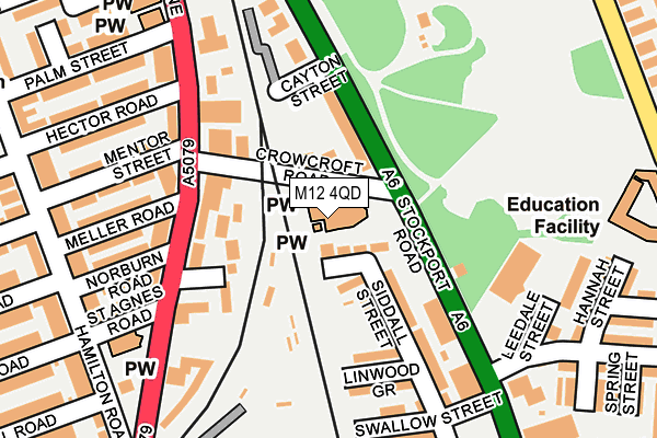
M12 4QD is located in the Longsight electoral ward, within the metropolitan district of Manchester and the English Parliamentary constituency of Manchester, Gorton. The Sub Integrated Care Board (ICB) Location is NHS Greater Manchester ICB - 14L and the police force is Greater Manchester. This postcode has been in use since January 1980.


GetTheData
Source: OS OpenMap – Local (Ordnance Survey)
Source: OS VectorMap District (Ordnance Survey)
Licence: Open Government Licence (requires attribution)
| Easting | 387149 |
| Northing | 394972 |
| Latitude | 53.451348 |
| Longitude | -2.194976 |
GetTheData
Source: Open Postcode Geo
Licence: Open Government Licence
| Country | England |
| Postcode District | M12 |
➜ See where M12 is on a map ➜ Where is Manchester? | |
GetTheData
Source: Land Registry Price Paid Data
Licence: Open Government Licence
Elevation or altitude of M12 4QD as distance above sea level:
| Metres | Feet | |
|---|---|---|
| Elevation | 50m | 164ft |
Elevation is measured from the approximate centre of the postcode, to the nearest point on an OS contour line from OS Terrain 50, which has contour spacing of ten vertical metres.
➜ How high above sea level am I? Find the elevation of your current position using your device's GPS.
GetTheData
Source: Open Postcode Elevation
Licence: Open Government Licence
| Ward | Longsight |
| Constituency | Manchester, Gorton |
GetTheData
Source: ONS Postcode Database
Licence: Open Government Licence
| Crowcroft Road | Longsight | 104m |
| Slade Ln/Crowcroft Rd (Slade Ln) | Longsight | 124m |
| Stockport Rd/East Rd (Stockport Rd) | Crowcroft Park | 169m |
| Stockport Rd/Matthews Ln (Stockport Rd) | Crowcroft Park | 170m |
| Slade Ln/Crowcroft Rd (Slade Ln) | Longsight | 175m |
| Levenshulme Station | 0.8km |
| Belle Vue Station | 1.6km |
| Ryder Brow Station | 1.6km |
GetTheData
Source: NaPTAN
Licence: Open Government Licence
GetTheData
Source: ONS Postcode Database
Licence: Open Government Licence


➜ Get more ratings from the Food Standards Agency
GetTheData
Source: Food Standards Agency
Licence: FSA terms & conditions
| Last Collection | |||
|---|---|---|---|
| Location | Mon-Fri | Sat | Distance |
| Turnbull Road | 17:30 | 12:00 | 259m |
| Stovell Avenue | 17:30 | 12:00 | 324m |
| East Road / North Road | 17:30 | 12:00 | 361m |
GetTheData
Source: Dracos
Licence: Creative Commons Attribution-ShareAlike
The below table lists the International Territorial Level (ITL) codes (formerly Nomenclature of Territorial Units for Statistics (NUTS) codes) and Local Administrative Units (LAU) codes for M12 4QD:
| ITL 1 Code | Name |
|---|---|
| TLD | North West (England) |
| ITL 2 Code | Name |
| TLD3 | Greater Manchester |
| ITL 3 Code | Name |
| TLD33 | Manchester |
| LAU 1 Code | Name |
| E08000003 | Manchester |
GetTheData
Source: ONS Postcode Directory
Licence: Open Government Licence
The below table lists the Census Output Area (OA), Lower Layer Super Output Area (LSOA), and Middle Layer Super Output Area (MSOA) for M12 4QD:
| Code | Name | |
|---|---|---|
| OA | E00026521 | |
| LSOA | E01005238 | Manchester 027F |
| MSOA | E02001071 | Manchester 027 |
GetTheData
Source: ONS Postcode Directory
Licence: Open Government Licence
| M12 4QF | Slade Hall Road | 36m |
| M12 4DF | Crowcroft Road | 55m |
| M12 4GB | Stockport Road | 91m |
| M13 0GQ | Dobcross Close | 98m |
| M13 0GW | Slade Lane | 118m |
| M12 4GE | Siddall Street | 129m |
| M12 4GD | Stockport Road | 152m |
| M12 4QH | Linwood Grove | 161m |
| M13 0GN | Slade Lane | 165m |
| M13 0GL | Slade Lane | 196m |
GetTheData
Source: Open Postcode Geo; Land Registry Price Paid Data
Licence: Open Government Licence