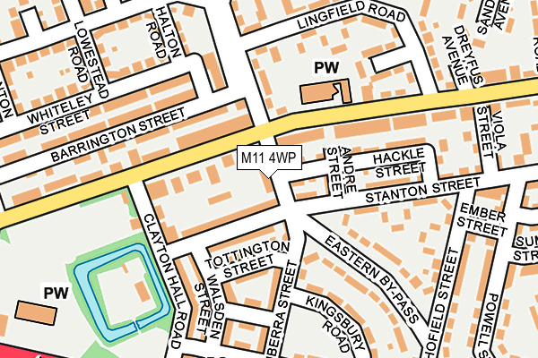
M11 4WP is in Oaks Road, Manchester. M11 4WP is located in the Clayton & Openshaw electoral ward, within the metropolitan district of Manchester and the English Parliamentary constituency of Manchester Central. The Sub Integrated Care Board (ICB) Location is NHS Greater Manchester ICB - 14L and the police force is Greater Manchester. This postcode has been in use since January 2008.


GetTheData
Source: OS OpenMap – Local (Ordnance Survey)
Source: OS VectorMap District (Ordnance Survey)
Licence: Open Government Licence (requires attribution)
| Easting | 388281 |
| Northing | 398699 |
| Latitude | 53.484891 |
| Longitude | -2.178069 |
GetTheData
Source: Open Postcode Geo
Licence: Open Government Licence
| Locality | Oaks Road |
| Town/City | Manchester |
| Country | England |
| Postcode District | M11 |
➜ See where M11 is on a map ➜ Where is Manchester? | |
GetTheData
Source: Land Registry Price Paid Data
Licence: Open Government Licence
Elevation or altitude of M11 4WP as distance above sea level:
| Metres | Feet | |
|---|---|---|
| Elevation | 80m | 262ft |
Elevation is measured from the approximate centre of the postcode, to the nearest point on an OS contour line from OS Terrain 50, which has contour spacing of ten vertical metres.
➜ How high above sea level am I? Find the elevation of your current position using your device's GPS.
GetTheData
Source: Open Postcode Elevation
Licence: Open Government Licence
| Ward | Clayton & Openshaw |
| Constituency | Manchester Central |
GetTheData
Source: ONS Postcode Database
Licence: Open Government Licence
| North Rd/Vale St (North Rd) | Clayton | 65m |
| North Rd/Vale St (North Rd) | Clayton | 69m |
| Eastern By Pass/Canberra St (Eastern Bypass) | Clayton | 78m |
| Eastern By Pass/Canberra St (Eastern By Pass) | Clayton | 90m |
| North Rd/Clayton Hall Rd (North Rd) | Clayton | 165m |
| Clayton Hall (Manchester Metrolink) (Ashton New Road) | Clayton | 358m |
| Edge Lane (Manchester Metrolink) (Manchester Road) | Droylsden | 963m |
| Velopark (Manchester Metrolink) (Ashton New Road) | Sportcity | 1,034m |
| Ashburys Station | 1.8km |
| Gorton Station | 1.9km |
| Belle Vue Station | 2.5km |
GetTheData
Source: NaPTAN
Licence: Open Government Licence
| Percentage of properties with Next Generation Access | 100.0% |
| Percentage of properties with Superfast Broadband | 100.0% |
| Percentage of properties with Ultrafast Broadband | 0.0% |
| Percentage of properties with Full Fibre Broadband | 0.0% |
Superfast Broadband is between 30Mbps and 300Mbps
Ultrafast Broadband is > 300Mbps
| Median download speed | 12.1Mbps |
| Average download speed | 36.6Mbps |
| Maximum download speed | 78.12Mbps |
| Median upload speed | 1.0Mbps |
| Average upload speed | 8.3Mbps |
| Maximum upload speed | 19.53Mbps |
| Percentage of properties unable to receive 2Mbps | 0.0% |
| Percentage of properties unable to receive 5Mbps | 0.0% |
| Percentage of properties unable to receive 10Mbps | 0.0% |
| Percentage of properties unable to receive 30Mbps | 0.0% |
GetTheData
Source: Ofcom
Licence: Ofcom Terms of Use (requires attribution)
GetTheData
Source: ONS Postcode Database
Licence: Open Government Licence


➜ Get more ratings from the Food Standards Agency
GetTheData
Source: Food Standards Agency
Licence: FSA terms & conditions
| Last Collection | |||
|---|---|---|---|
| Location | Mon-Fri | Sat | Distance |
| Opp 145 North Road | 17:30 | 12:00 | 153m |
| Clayton P.o. | 17:30 | 12:00 | 282m |
| 136 Stanton Street | 17:30 | 12:00 | 288m |
GetTheData
Source: Dracos
Licence: Creative Commons Attribution-ShareAlike
The below table lists the International Territorial Level (ITL) codes (formerly Nomenclature of Territorial Units for Statistics (NUTS) codes) and Local Administrative Units (LAU) codes for M11 4WP:
| ITL 1 Code | Name |
|---|---|
| TLD | North West (England) |
| ITL 2 Code | Name |
| TLD3 | Greater Manchester |
| ITL 3 Code | Name |
| TLD33 | Manchester |
| LAU 1 Code | Name |
| E08000003 | Manchester |
GetTheData
Source: ONS Postcode Directory
Licence: Open Government Licence
The below table lists the Census Output Area (OA), Lower Layer Super Output Area (LSOA), and Middle Layer Super Output Area (MSOA) for M11 4WP:
| Code | Name | |
|---|---|---|
| OA | E00025763 | |
| LSOA | E01005093 | Manchester 012A |
| MSOA | E02001056 | Manchester 012 |
GetTheData
Source: ONS Postcode Directory
Licence: Open Government Licence
| M11 4WF | 39m | |
| M11 4WE | North Road | 46m |
| M11 4NH | Stanton Street | 65m |
| M11 4NF | North Road | 70m |
| M11 4NQ | Andre Street | 92m |
| M11 4WT | Tottington Street | 97m |
| M11 4NG | North Road | 116m |
| M11 4JX | Ladylands Avenue | 124m |
| M11 4WL | Canberra Street | 127m |
| M11 4WW | Stanton Street | 130m |
GetTheData
Source: Open Postcode Geo; Land Registry Price Paid Data
Licence: Open Government Licence