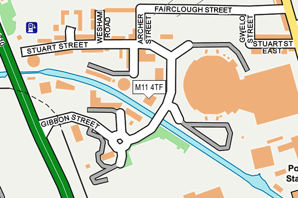
M11 4TF lies on Stillwater Drive in Manchester. M11 4TF is located in the Clayton & Openshaw electoral ward, within the metropolitan district of Manchester and the English Parliamentary constituency of Manchester Central. The Sub Integrated Care Board (ICB) Location is NHS Greater Manchester ICB - 14L and the police force is Greater Manchester. This postcode has been in use since January 2007.


GetTheData
Source: OS OpenMap – Local (Ordnance Survey)
Source: OS VectorMap District (Ordnance Survey)
Licence: Open Government Licence (requires attribution)
| Easting | 387235 |
| Northing | 398748 |
| Latitude | 53.485307 |
| Longitude | -2.193834 |
GetTheData
Source: Open Postcode Geo
Licence: Open Government Licence
| Street | Stillwater Drive |
| Town/City | Manchester |
| Country | England |
| Postcode District | M11 |
➜ See where M11 is on a map ➜ Where is Manchester? | |
GetTheData
Source: Land Registry Price Paid Data
Licence: Open Government Licence
Elevation or altitude of M11 4TF as distance above sea level:
| Metres | Feet | |
|---|---|---|
| Elevation | 70m | 230ft |
Elevation is measured from the approximate centre of the postcode, to the nearest point on an OS contour line from OS Terrain 50, which has contour spacing of ten vertical metres.
➜ How high above sea level am I? Find the elevation of your current position using your device's GPS.
GetTheData
Source: Open Postcode Elevation
Licence: Open Government Licence
| Ward | Clayton & Openshaw |
| Constituency | Manchester Central |
GetTheData
Source: ONS Postcode Database
Licence: Open Government Licence
| Etihad Campus Tram Stop (Alan Turing Way) | Sportcity | 217m |
| Etihad Campus Tram Stop (Alan Turing Way) | Sportcity | 265m |
| Bank St/Tartan St (Bank St) | Clayton | 314m |
| Bank St/Ravensbury Sch (Bank St) | Clayton | 326m |
| Velopark Tram Stop (Ashton New Rd) | Sportcity | 348m |
| Velopark (Manchester Metrolink) (Ashton New Road) | Sportcity | 341m |
| Etihad Campus (Manchester Metrolink) (Joe Mercer Way) | Sportcity | 498m |
| Clayton Hall (Manchester Metrolink) (Ashton New Road) | Clayton | 823m |
| Holt Town (Manchester Metrolink) (Holt Town) | Holt Town | 1,240m |
| Ashburys Station | 1.5km |
| Ardwick Station | 2km |
| Gorton Station | 2.6km |
GetTheData
Source: NaPTAN
Licence: Open Government Licence
| Percentage of properties with Next Generation Access | 100.0% |
| Percentage of properties with Superfast Broadband | 100.0% |
| Percentage of properties with Ultrafast Broadband | 100.0% |
| Percentage of properties with Full Fibre Broadband | 100.0% |
Superfast Broadband is between 30Mbps and 300Mbps
Ultrafast Broadband is > 300Mbps
| Median download speed | 15.8Mbps |
| Average download speed | 35.8Mbps |
| Maximum download speed | 76.88Mbps |
| Median upload speed | 1.3Mbps |
| Average upload speed | 8.7Mbps |
| Maximum upload speed | 20.00Mbps |
| Percentage of properties unable to receive 2Mbps | 0.0% |
| Percentage of properties unable to receive 5Mbps | 0.0% |
| Percentage of properties unable to receive 10Mbps | 0.0% |
| Percentage of properties unable to receive 30Mbps | 0.0% |
GetTheData
Source: Ofcom
Licence: Ofcom Terms of Use (requires attribution)
Estimated total energy consumption in M11 4TF by fuel type, 2015.
| Consumption (kWh) | 320,990 |
|---|---|
| Meter count | 68 |
| Mean (kWh/meter) | 4,720 |
| Median (kWh/meter) | 4,369 |
GetTheData
Source: Postcode level gas estimates: 2015 (experimental)
Source: Postcode level electricity estimates: 2015 (experimental)
Licence: Open Government Licence
GetTheData
Source: ONS Postcode Database
Licence: Open Government Licence


➜ Get more ratings from the Food Standards Agency
GetTheData
Source: Food Standards Agency
Licence: FSA terms & conditions
| Last Collection | |||
|---|---|---|---|
| Location | Mon-Fri | Sat | Distance |
| 95 Stuart Street | 17:30 | 12:00 | 318m |
| 579 Ashton New Road | 17:30 | 12:00 | 449m |
| Wellington Street | 17:30 | 12:00 | 683m |
GetTheData
Source: Dracos
Licence: Creative Commons Attribution-ShareAlike
The below table lists the International Territorial Level (ITL) codes (formerly Nomenclature of Territorial Units for Statistics (NUTS) codes) and Local Administrative Units (LAU) codes for M11 4TF:
| ITL 1 Code | Name |
|---|---|
| TLD | North West (England) |
| ITL 2 Code | Name |
| TLD3 | Greater Manchester |
| ITL 3 Code | Name |
| TLD33 | Manchester |
| LAU 1 Code | Name |
| E08000003 | Manchester |
GetTheData
Source: ONS Postcode Directory
Licence: Open Government Licence
The below table lists the Census Output Area (OA), Lower Layer Super Output Area (LSOA), and Middle Layer Super Output Area (MSOA) for M11 4TF:
| Code | Name | |
|---|---|---|
| OA | E00175877 | |
| LSOA | E01033668 | Manchester 015F |
| MSOA | E02001059 | Manchester 015 |
GetTheData
Source: ONS Postcode Directory
Licence: Open Government Licence
| M11 4AY | The Waterfront | 42m |
| M11 4TE | Stillwater Drive | 47m |
| M11 4TG | Stillwater Drive | 60m |
| M11 4AU | The Waterfront | 71m |
| M11 4TD | Stillwater Drive | 90m |
| M11 4TL | Stillwater Drive | 96m |
| M11 4AF | The Waterfront | 110m |
| M11 4TP | Stillwater Drive | 111m |
| M11 4DY | Archer Street | 125m |
| M11 4DU | Stuart Street | 152m |
GetTheData
Source: Open Postcode Geo; Land Registry Price Paid Data
Licence: Open Government Licence