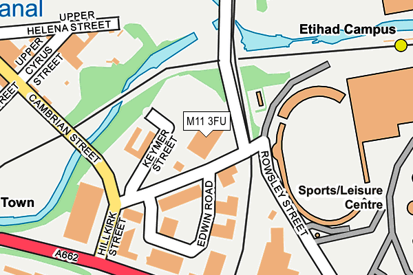
M11 3FU is located in the Ancoats & Beswick electoral ward, within the metropolitan district of Manchester and the English Parliamentary constituency of Manchester Central. The Sub Integrated Care Board (ICB) Location is NHS Greater Manchester ICB - 14L and the police force is Greater Manchester. This postcode has been in use since January 1992.


GetTheData
Source: OS OpenMap – Local (Ordnance Survey)
Source: OS VectorMap District (Ordnance Survey)
Licence: Open Government Licence (requires attribution)
| Easting | 386391 |
| Northing | 398618 |
| Latitude | 53.484101 |
| Longitude | -2.206549 |
GetTheData
Source: Open Postcode Geo
Licence: Open Government Licence
| Country | England |
| Postcode District | M11 |
➜ See where M11 is on a map ➜ Where is Manchester? | |
GetTheData
Source: Land Registry Price Paid Data
Licence: Open Government Licence
Elevation or altitude of M11 3FU as distance above sea level:
| Metres | Feet | |
|---|---|---|
| Elevation | 50m | 164ft |
Elevation is measured from the approximate centre of the postcode, to the nearest point on an OS contour line from OS Terrain 50, which has contour spacing of ten vertical metres.
➜ How high above sea level am I? Find the elevation of your current position using your device's GPS.
GetTheData
Source: Open Postcode Elevation
Licence: Open Government Licence
| Ward | Ancoats & Beswick |
| Constituency | Manchester Central |
GetTheData
Source: ONS Postcode Database
Licence: Open Government Licence
| Ashton New Rd/Councillor St (Ashton New Rd) | Beswick | 219m |
| Ashton New Rd/Hillkirk St (Ashton New Rd) | Beswick | 235m |
| Ashton New Rd/Darley St (Ashton New Rd) | Beswick | 268m |
| Ashton New Rd/Etihad Stadium (Ashton New Rd) | Sportcity | 355m |
| Palmerston St/Kirkbridge Rd (Palmerston St) | Beswick | 370m |
| Etihad Campus (Manchester Metrolink) (Joe Mercer Way) | Sportcity | 373m |
| Holt Town (Manchester Metrolink) (Holt Town) | Holt Town | 388m |
| Velopark (Manchester Metrolink) (Ashton New Road) | Sportcity | 921m |
| New Islington (Manchester Metrolink) (Pollard Street) | New Islington | 941m |
| Ardwick Station | 1.5km |
| Ashburys Station | 1.6km |
| Manchester Piccadilly Station | 1.8km |
GetTheData
Source: NaPTAN
Licence: Open Government Licence
GetTheData
Source: ONS Postcode Database
Licence: Open Government Licence


➜ Get more ratings from the Food Standards Agency
GetTheData
Source: Food Standards Agency
Licence: FSA terms & conditions
| Last Collection | |||
|---|---|---|---|
| Location | Mon-Fri | Sat | Distance |
| Darley Street | 17:30 | 12:00 | 308m |
| Ashton New Road P.o. | 19:00 | 12:00 | 486m |
| Every Street | 19:00 | 12:00 | 691m |
GetTheData
Source: Dracos
Licence: Creative Commons Attribution-ShareAlike
The below table lists the International Territorial Level (ITL) codes (formerly Nomenclature of Territorial Units for Statistics (NUTS) codes) and Local Administrative Units (LAU) codes for M11 3FU:
| ITL 1 Code | Name |
|---|---|
| TLD | North West (England) |
| ITL 2 Code | Name |
| TLD3 | Greater Manchester |
| ITL 3 Code | Name |
| TLD33 | Manchester |
| LAU 1 Code | Name |
| E08000003 | Manchester |
GetTheData
Source: ONS Postcode Directory
Licence: Open Government Licence
The below table lists the Census Output Area (OA), Lower Layer Super Output Area (LSOA), and Middle Layer Super Output Area (MSOA) for M11 3FU:
| Code | Name | |
|---|---|---|
| OA | E00025772 | |
| LSOA | E01033688 | Manchester 013G |
| MSOA | E02001057 | Manchester 013 |
GetTheData
Source: ONS Postcode Directory
Licence: Open Government Licence
| M11 3FX | Philips Park Road | 157m |
| M40 7EG | Cambrian Street | 267m |
| M12 6PL | Bellis Close | 267m |
| M12 6PJ | Ramage Walk | 296m |
| M12 6PR | Purslow Close | 298m |
| M40 7EP | Cambrian Street | 322m |
| M11 3JY | Orme Close | 347m |
| M12 6PH | Blakemore Walk | 357m |
| M11 3JF | Viking Close | 357m |
| M12 6PT | Palmerston Street | 360m |
GetTheData
Source: Open Postcode Geo; Land Registry Price Paid Data
Licence: Open Government Licence