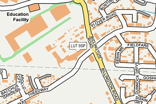
LU7 9SP is located in the Leighton-Linslade South electoral ward, within the unitary authority of Central Bedfordshire and the English Parliamentary constituency of South West Bedfordshire. The Sub Integrated Care Board (ICB) Location is NHS Bedfordshire, Luton and Milton Keynes ICB - M1J4Y and the police force is Bedfordshire. This postcode has been in use since July 2016.


GetTheData
Source: OS OpenMap – Local (Ordnance Survey)
Source: OS VectorMap District (Ordnance Survey)
Licence: Open Government Licence (requires attribution)
| Easting | 492863 |
| Northing | 223719 |
| Latitude | 51.904282 |
| Longitude | -0.651603 |
GetTheData
Source: Open Postcode Geo
Licence: Open Government Licence
| Country | England |
| Postcode District | LU7 |
➜ See where LU7 is on a map ➜ Where is Leighton Buzzard? | |
GetTheData
Source: Land Registry Price Paid Data
Licence: Open Government Licence
Elevation or altitude of LU7 9SP as distance above sea level:
| Metres | Feet | |
|---|---|---|
| Elevation | 90m | 295ft |
Elevation is measured from the approximate centre of the postcode, to the nearest point on an OS contour line from OS Terrain 50, which has contour spacing of ten vertical metres.
➜ How high above sea level am I? Find the elevation of your current position using your device's GPS.
GetTheData
Source: Open Postcode Elevation
Licence: Open Government Licence
| Ward | Leighton-linslade South |
| Constituency | South West Bedfordshire |
GetTheData
Source: ONS Postcode Database
Licence: Open Government Licence
| Kestrel Way | Leighton Buzzard | 253m |
| Draper Way (Johnson Drive) | Leighton Buzzard | 311m |
| Narrow Gauge Railway (Billington Road) | Leighton Buzzard | 445m |
| Eden Way (Chartmoor Road) | Leighton Buzzard | 454m |
| Richmond Road | Leighton Buzzard | 727m |
| Leighton Buzzard Station | 2.2km |
GetTheData
Source: NaPTAN
Licence: Open Government Licence
| Percentage of properties with Next Generation Access | 100.0% |
| Percentage of properties with Superfast Broadband | 100.0% |
| Percentage of properties with Ultrafast Broadband | 100.0% |
| Percentage of properties with Full Fibre Broadband | 100.0% |
Superfast Broadband is between 30Mbps and 300Mbps
Ultrafast Broadband is > 300Mbps
| Median download speed | 12.6Mbps |
| Average download speed | 12.0Mbps |
| Maximum download speed | 18.08Mbps |
| Median upload speed | 1.0Mbps |
| Average upload speed | 1.0Mbps |
| Maximum upload speed | 1.28Mbps |
| Percentage of properties unable to receive 2Mbps | 0.0% |
| Percentage of properties unable to receive 5Mbps | 0.0% |
| Percentage of properties unable to receive 10Mbps | 0.0% |
| Percentage of properties unable to receive 30Mbps | 0.0% |
GetTheData
Source: Ofcom
Licence: Ofcom Terms of Use (requires attribution)
GetTheData
Source: ONS Postcode Database
Licence: Open Government Licence


➜ Get more ratings from the Food Standards Agency
GetTheData
Source: Food Standards Agency
Licence: FSA terms & conditions
| Last Collection | |||
|---|---|---|---|
| Location | Mon-Fri | Sat | Distance |
| Johnson Drive | 17:00 | 12:00 | 296m |
| Grovebury Service Station | 17:15 | 11:00 | 342m |
| Delivery Office Firbank Way | 18:30 | 13:00 | 570m |
GetTheData
Source: Dracos
Licence: Creative Commons Attribution-ShareAlike
The below table lists the International Territorial Level (ITL) codes (formerly Nomenclature of Territorial Units for Statistics (NUTS) codes) and Local Administrative Units (LAU) codes for LU7 9SP:
| ITL 1 Code | Name |
|---|---|
| TLH | East |
| ITL 2 Code | Name |
| TLH2 | Bedfordshire and Hertfordshire |
| ITL 3 Code | Name |
| TLH25 | Central Bedfordshire |
| LAU 1 Code | Name |
| E06000056 | Central Bedfordshire |
GetTheData
Source: ONS Postcode Directory
Licence: Open Government Licence
The below table lists the Census Output Area (OA), Lower Layer Super Output Area (LSOA), and Middle Layer Super Output Area (MSOA) for LU7 9SP:
| Code | Name | |
|---|---|---|
| OA | E00171405 | |
| LSOA | E01033193 | Central Bedfordshire 024G |
| MSOA | E02003643 | Central Bedfordshire 024 |
GetTheData
Source: ONS Postcode Directory
Licence: Open Government Licence
| LU7 4DE | Sparrow Path | 112m |
| LU7 9RY | Aurora Rise | 161m |
| LU7 4DU | Serin Mead | 164m |
| LU7 4AX | Kestrel Way | 180m |
| LU7 4AW | Plover Road | 195m |
| LU7 4AU | Bunting Drive | 213m |
| LU7 4DS | Wryneck | 214m |
| LU7 9HH | Billington Road | 233m |
| LU7 4DL | Dunnock Drive | 246m |
| LU7 4TQ | Bushell Close | 248m |
GetTheData
Source: Open Postcode Geo; Land Registry Price Paid Data
Licence: Open Government Licence