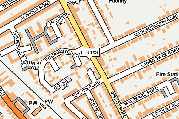
LU3 1XS lies on Biscot Road in Luton. LU3 1XS is located in the Biscot electoral ward, within the unitary authority of Luton and the English Parliamentary constituency of Luton South. The Sub Integrated Care Board (ICB) Location is NHS Bedfordshire, Luton and Milton Keynes ICB - M1J4Y and the police force is Bedfordshire. This postcode has been in use since February 1990.


GetTheData
Source: OS OpenMap – Local (Ordnance Survey)
Source: OS VectorMap District (Ordnance Survey)
Licence: Open Government Licence (requires attribution)
| Easting | 508331 |
| Northing | 222319 |
| Latitude | 51.888910 |
| Longitude | -0.427293 |
GetTheData
Source: Open Postcode Geo
Licence: Open Government Licence
| Street | Biscot Road |
| Town/City | Luton |
| Country | England |
| Postcode District | LU3 |
➜ See where LU3 is on a map ➜ Where is Luton? | |
GetTheData
Source: Land Registry Price Paid Data
Licence: Open Government Licence
Elevation or altitude of LU3 1XS as distance above sea level:
| Metres | Feet | |
|---|---|---|
| Elevation | 110m | 361ft |
Elevation is measured from the approximate centre of the postcode, to the nearest point on an OS contour line from OS Terrain 50, which has contour spacing of ten vertical metres.
➜ How high above sea level am I? Find the elevation of your current position using your device's GPS.
GetTheData
Source: Open Postcode Elevation
Licence: Open Government Licence
| Ward | Biscot |
| Constituency | Luton South |
GetTheData
Source: ONS Postcode Database
Licence: Open Government Licence
87, BISCOT ROAD, LUTON, LU3 1XS 1995 14 FEB £50,000 |
GetTheData
Source: HM Land Registry Price Paid Data
Licence: Contains HM Land Registry data © Crown copyright and database right 2025. This data is licensed under the Open Government Licence v3.0.
| Dorrington Close (Biscot Road) | Biscot | 79m |
| Dorrington Close (Biscot Road) | Biscot | 131m |
| Studley Road (Biscot Road) | Biscot | 290m |
| Studley Road (Biscot Road) | Biscot | 303m |
| Selbourne Road (Leagrave Road) | Bury Park | 324m |
| Luton Station | 1.2km |
| Leagrave Station | 2.8km |
| Luton Airport Parkway Station | 2.8km |
GetTheData
Source: NaPTAN
Licence: Open Government Licence
| Percentage of properties with Next Generation Access | 100.0% |
| Percentage of properties with Superfast Broadband | 100.0% |
| Percentage of properties with Ultrafast Broadband | 100.0% |
| Percentage of properties with Full Fibre Broadband | 0.0% |
Superfast Broadband is between 30Mbps and 300Mbps
Ultrafast Broadband is > 300Mbps
| Percentage of properties unable to receive 2Mbps | 0.0% |
| Percentage of properties unable to receive 5Mbps | 0.0% |
| Percentage of properties unable to receive 10Mbps | 0.0% |
| Percentage of properties unable to receive 30Mbps | 0.0% |
GetTheData
Source: Ofcom
Licence: Ofcom Terms of Use (requires attribution)
Estimated total energy consumption in LU3 1XS by fuel type, 2015.
| Consumption (kWh) | 39,440 |
|---|---|
| Meter count | 7 |
| Mean (kWh/meter) | 5,634 |
| Median (kWh/meter) | 3,072 |
GetTheData
Source: Postcode level gas estimates: 2015 (experimental)
Source: Postcode level electricity estimates: 2015 (experimental)
Licence: Open Government Licence
GetTheData
Source: ONS Postcode Database
Licence: Open Government Licence


➜ Get more ratings from the Food Standards Agency
GetTheData
Source: Food Standards Agency
Licence: FSA terms & conditions
| Last Collection | |||
|---|---|---|---|
| Location | Mon-Fri | Sat | Distance |
| Biscot Road | 17:30 | 12:30 | 267m |
| Post Office Biscot Road | 18:30 | 12:30 | 352m |
| Post Office Bury Park | 18:30 | 12:30 | 366m |
GetTheData
Source: Dracos
Licence: Creative Commons Attribution-ShareAlike
The below table lists the International Territorial Level (ITL) codes (formerly Nomenclature of Territorial Units for Statistics (NUTS) codes) and Local Administrative Units (LAU) codes for LU3 1XS:
| ITL 1 Code | Name |
|---|---|
| TLH | East |
| ITL 2 Code | Name |
| TLH2 | Bedfordshire and Hertfordshire |
| ITL 3 Code | Name |
| TLH21 | Luton |
| LAU 1 Code | Name |
| E06000032 | Luton |
GetTheData
Source: ONS Postcode Directory
Licence: Open Government Licence
The below table lists the Census Output Area (OA), Lower Layer Super Output Area (LSOA), and Middle Layer Super Output Area (MSOA) for LU3 1XS:
| Code | Name | |
|---|---|---|
| OA | E00173612 | |
| LSOA | E01015702 | Luton 017C |
| MSOA | E02003274 | Luton 017 |
GetTheData
Source: ONS Postcode Directory
Licence: Open Government Licence
| LU3 1XH | Ellenhall Close | 60m |
| LU3 1XL | Dorrington Close | 63m |
| LU3 1AU | Biscot Road | 74m |
| LU3 1XJ | Coyney Green | 78m |
| LU3 1BG | Curzon Road | 118m |
| LU3 1XR | Dorrington Close | 125m |
| LU3 1AG | Milliners Way | 142m |
| LU3 1XP | Dorrington Close | 143m |
| LU3 1EG | Argyll Avenue | 151m |
| LU3 1BQ | Whitby Road | 167m |
GetTheData
Source: Open Postcode Geo; Land Registry Price Paid Data
Licence: Open Government Licence