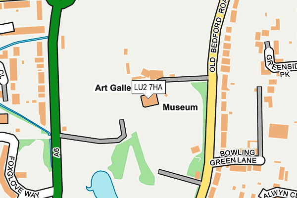
LU2 7HA is located in the High Town electoral ward, within the unitary authority of Luton and the English Parliamentary constituency of Luton South. The Sub Integrated Care Board (ICB) Location is NHS Bedfordshire, Luton and Milton Keynes ICB - M1J4Y and the police force is Bedfordshire. This postcode has been in use since June 1998.


GetTheData
Source: OS OpenMap – Local (Ordnance Survey)
Source: OS VectorMap District (Ordnance Survey)
Licence: Open Government Licence (requires attribution)
| Easting | 508930 |
| Northing | 222972 |
| Latitude | 51.894662 |
| Longitude | -0.418387 |
GetTheData
Source: Open Postcode Geo
Licence: Open Government Licence
| Country | England |
| Postcode District | LU2 |
➜ See where LU2 is on a map ➜ Where is Luton? | |
GetTheData
Source: Land Registry Price Paid Data
Licence: Open Government Licence
Elevation or altitude of LU2 7HA as distance above sea level:
| Metres | Feet | |
|---|---|---|
| Elevation | 110m | 361ft |
Elevation is measured from the approximate centre of the postcode, to the nearest point on an OS contour line from OS Terrain 50, which has contour spacing of ten vertical metres.
➜ How high above sea level am I? Find the elevation of your current position using your device's GPS.
GetTheData
Source: Open Postcode Elevation
Licence: Open Government Licence
| Ward | High Town |
| Constituency | Luton South |
GetTheData
Source: ONS Postcode Database
Licence: Open Government Licence
| Bowling Green Lane (Old Bedford Road) | Wardown | 128m |
| Bowling Green Lane (Old Bedford Road) | Wardown | 162m |
| Cricket Ground (Old Bedford Road) | Wardown | 185m |
| Bath Road (New Bedford Road) | Wardown | 195m |
| Cricket Ground (Old Bedford Road) | Wardown | 213m |
| Luton Station | 1.4km |
| Luton Airport Parkway Station | 2.9km |
| Leagrave Station | 3km |
GetTheData
Source: NaPTAN
Licence: Open Government Licence
GetTheData
Source: ONS Postcode Database
Licence: Open Government Licence


➜ Get more ratings from the Food Standards Agency
GetTheData
Source: Food Standards Agency
Licence: FSA terms & conditions
| Last Collection | |||
|---|---|---|---|
| Location | Mon-Fri | Sat | Distance |
| Wardown Museum | 17:30 | 12:30 | 27m |
| Manton Drive | 17:30 | 12:30 | 305m |
| Wardown Crescent | 17:30 | 12:30 | 309m |
GetTheData
Source: Dracos
Licence: Creative Commons Attribution-ShareAlike
The below table lists the International Territorial Level (ITL) codes (formerly Nomenclature of Territorial Units for Statistics (NUTS) codes) and Local Administrative Units (LAU) codes for LU2 7HA:
| ITL 1 Code | Name |
|---|---|
| TLH | East |
| ITL 2 Code | Name |
| TLH2 | Bedfordshire and Hertfordshire |
| ITL 3 Code | Name |
| TLH21 | Luton |
| LAU 1 Code | Name |
| E06000032 | Luton |
GetTheData
Source: ONS Postcode Directory
Licence: Open Government Licence
The below table lists the Census Output Area (OA), Lower Layer Super Output Area (LSOA), and Middle Layer Super Output Area (MSOA) for LU2 7HA:
| Code | Name | |
|---|---|---|
| OA | E00079582 | |
| LSOA | E01015740 | Luton 012A |
| MSOA | E02003269 | Luton 012 |
GetTheData
Source: ONS Postcode Directory
Licence: Open Government Licence
| LU2 7HP | Old Bedford Road | 157m |
| LU3 1LJ | New Bedford Road | 228m |
| LU2 7HR | Bowling Green Lane | 234m |
| LU2 7DD | Stockingstone Road | 244m |
| LU2 7HW | Old Bedford Road | 244m |
| LU2 7DE | Stockingstone Road | 257m |
| LU2 7JF | Greenside Park | 274m |
| LU3 1DY | Foxglove Way | 301m |
| LU3 1EU | Primrose Close | 302m |
| LU2 7JX | Alwyn Close | 319m |
GetTheData
Source: Open Postcode Geo; Land Registry Price Paid Data
Licence: Open Government Licence