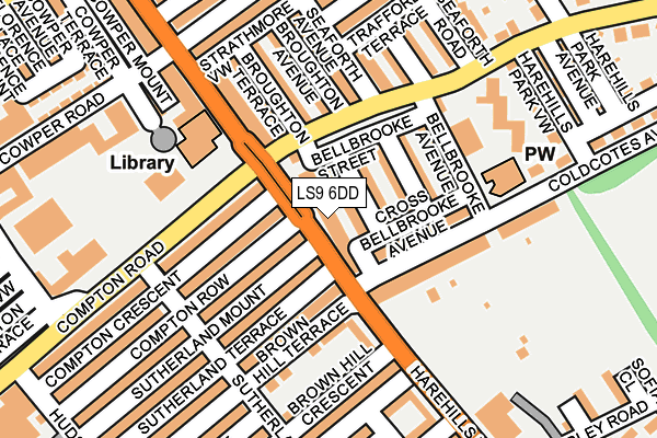
LS9 6DD is located in the Burmantofts & Richmond Hill electoral ward, within the metropolitan district of Leeds and the English Parliamentary constituency of Leeds Central. The Sub Integrated Care Board (ICB) Location is NHS West Yorkshire ICB - 15F and the police force is West Yorkshire. This postcode has been in use since October 2008.


GetTheData
Source: OS OpenMap – Local (Ordnance Survey)
Source: OS VectorMap District (Ordnance Survey)
Licence: Open Government Licence (requires attribution)
| Easting | 432499 |
| Northing | 434787 |
| Latitude | 53.808365 |
| Longitude | -1.507965 |
GetTheData
Source: Open Postcode Geo
Licence: Open Government Licence
| Country | England |
| Postcode District | LS9 |
➜ See where LS9 is on a map ➜ Where is Leeds? | |
GetTheData
Source: Land Registry Price Paid Data
Licence: Open Government Licence
Elevation or altitude of LS9 6DD as distance above sea level:
| Metres | Feet | |
|---|---|---|
| Elevation | 80m | 262ft |
Elevation is measured from the approximate centre of the postcode, to the nearest point on an OS contour line from OS Terrain 50, which has contour spacing of ten vertical metres.
➜ How high above sea level am I? Find the elevation of your current position using your device's GPS.
GetTheData
Source: Open Postcode Elevation
Licence: Open Government Licence
| Ward | Burmantofts & Richmond Hill |
| Constituency | Leeds Central |
GetTheData
Source: ONS Postcode Database
Licence: Open Government Licence
| The Compton Centre (Compton Road) | Harehills | 112m |
| The Compton Centre (Compton Road) | Harehills | 123m |
| Harehills Ln Cowper Road (Harehills Lane) | Harehills | 169m |
| Harehills Ln Strathmore Drive (Harehills Lane) | Harehills | 194m |
| Harehills Lane Clifton Ave (Harehills Lane) | Harehills | 210m |
| Leeds Station | 3km |
| Cross Gates Station | 3.7km |
| Burley Park Station | 4.6km |
GetTheData
Source: NaPTAN
Licence: Open Government Licence
GetTheData
Source: ONS Postcode Database
Licence: Open Government Licence


➜ Get more ratings from the Food Standards Agency
GetTheData
Source: Food Standards Agency
Licence: FSA terms & conditions
| Last Collection | |||
|---|---|---|---|
| Location | Mon-Fri | Sat | Distance |
| Brownhills | 18:00 | 11:30 | 57m |
| Compton Road P.o. | 18:15 | 12:00 | 167m |
| Ashley Road | 18:15 | 11:00 | 337m |
GetTheData
Source: Dracos
Licence: Creative Commons Attribution-ShareAlike
The below table lists the International Territorial Level (ITL) codes (formerly Nomenclature of Territorial Units for Statistics (NUTS) codes) and Local Administrative Units (LAU) codes for LS9 6DD:
| ITL 1 Code | Name |
|---|---|
| TLE | Yorkshire and The Humber |
| ITL 2 Code | Name |
| TLE4 | West Yorkshire |
| ITL 3 Code | Name |
| TLE42 | Leeds |
| LAU 1 Code | Name |
| E08000035 | Leeds |
GetTheData
Source: ONS Postcode Directory
Licence: Open Government Licence
The below table lists the Census Output Area (OA), Lower Layer Super Output Area (LSOA), and Middle Layer Super Output Area (MSOA) for LS9 6DD:
| Code | Name | |
|---|---|---|
| OA | E00057189 | |
| LSOA | E01011344 | Leeds 065A |
| MSOA | E02002394 | Leeds 065 |
GetTheData
Source: ONS Postcode Directory
Licence: Open Government Licence
| LS9 6AP | Harehills Lane | 16m |
| LS9 6AR | Bellbrooke Place | 26m |
| LS9 6AT | Bellbrooke Grove | 70m |
| LS9 6AS | Bellbrooke Street | 82m |
| LS9 6DN | Compton Row | 93m |
| LS9 6DW | Sutherland Mount | 93m |
| LS9 6NA | Coldcotes Avenue | 94m |
| LS9 6DS | Sutherland Terrace | 97m |
| LS9 6BB | Foundry Approach | 97m |
| LS9 6DQ | Compton Crescent | 99m |
GetTheData
Source: Open Postcode Geo; Land Registry Price Paid Data
Licence: Open Government Licence