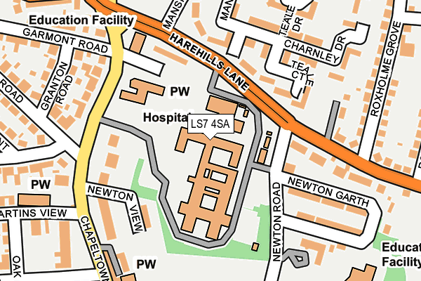
LS7 4SA is located in the Chapel Allerton electoral ward, within the metropolitan district of Leeds and the English Parliamentary constituency of Leeds North East. The Sub Integrated Care Board (ICB) Location is NHS West Yorkshire ICB - 15F and the police force is West Yorkshire. This postcode has been in use since January 1980.


GetTheData
Source: OS OpenMap – Local (Ordnance Survey)
Source: OS VectorMap District (Ordnance Survey)
Licence: Open Government Licence (requires attribution)
| Easting | 431050 |
| Northing | 436365 |
| Latitude | 53.822636 |
| Longitude | -1.529810 |
GetTheData
Source: Open Postcode Geo
Licence: Open Government Licence
| Country | England |
| Postcode District | LS7 |
➜ See where LS7 is on a map ➜ Where is Leeds? | |
GetTheData
Source: Land Registry Price Paid Data
Licence: Open Government Licence
Elevation or altitude of LS7 4SA as distance above sea level:
| Metres | Feet | |
|---|---|---|
| Elevation | 70m | 230ft |
Elevation is measured from the approximate centre of the postcode, to the nearest point on an OS contour line from OS Terrain 50, which has contour spacing of ten vertical metres.
➜ How high above sea level am I? Find the elevation of your current position using your device's GPS.
GetTheData
Source: Open Postcode Elevation
Licence: Open Government Licence
| Ward | Chapel Allerton |
| Constituency | Leeds North East |
GetTheData
Source: ONS Postcode Database
Licence: Open Government Licence
| Harehills Lane Newton Rd (Harehills Lane) | Chapel Allerton | 156m |
| Harehills Lane Roxholme Grove (Harehills Lane) | Chapel Allerton | 157m |
| Chapel Allerton Hospital (Chapeltown Road) | Chapeltown | 171m |
| Chapel Allerton Hospital (Chapeltown Road) | Chapeltown | 184m |
| Chapeltown Road Newton Parade (Chapeltown Road) | Chapeltown | 226m |
| Leeds Station | 3.2km |
| Burley Park Station | 3.4km |
| Headingley Station | 4.3km |
GetTheData
Source: NaPTAN
Licence: Open Government Licence
GetTheData
Source: ONS Postcode Database
Licence: Open Government Licence


➜ Get more ratings from the Food Standards Agency
GetTheData
Source: Food Standards Agency
Licence: FSA terms & conditions
| Last Collection | |||
|---|---|---|---|
| Location | Mon-Fri | Sat | Distance |
| Newton View/Chapeltown Road | 17:30 | 12:00 | 190m |
| Woodlands | 17:30 | 11:15 | 224m |
| Alberta Avenue | 17:30 | 11:15 | 481m |
GetTheData
Source: Dracos
Licence: Creative Commons Attribution-ShareAlike
The below table lists the International Territorial Level (ITL) codes (formerly Nomenclature of Territorial Units for Statistics (NUTS) codes) and Local Administrative Units (LAU) codes for LS7 4SA:
| ITL 1 Code | Name |
|---|---|
| TLE | Yorkshire and The Humber |
| ITL 2 Code | Name |
| TLE4 | West Yorkshire |
| ITL 3 Code | Name |
| TLE42 | Leeds |
| LAU 1 Code | Name |
| E08000035 | Leeds |
GetTheData
Source: ONS Postcode Directory
Licence: Open Government Licence
The below table lists the Census Output Area (OA), Lower Layer Super Output Area (LSOA), and Middle Layer Super Output Area (MSOA) for LS7 4SA:
| Code | Name | |
|---|---|---|
| OA | E00057207 | |
| LSOA | E01011356 | Leeds 042A |
| MSOA | E02002371 | Leeds 042 |
GetTheData
Source: ONS Postcode Directory
Licence: Open Government Licence
| LS7 4SZ | Oldfield Court | 119m |
| LS7 4EY | Harehills Lane | 138m |
| LS7 4AY | Teale Court | 139m |
| LS7 4JD | Newton View | 144m |
| LS7 4SW | Teale Drive | 152m |
| LS7 4HD | Harehills Lane | 154m |
| LS7 4HZ | Chapeltown Road | 164m |
| LS7 4HG | Newton Garth | 183m |
| LS7 4JB | St Martins Terrace | 188m |
| LS7 3LL | Chapeltown Road | 190m |
GetTheData
Source: Open Postcode Geo; Land Registry Price Paid Data
Licence: Open Government Licence