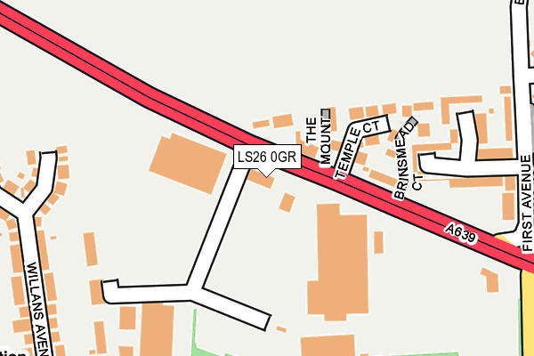
LS26 0GR is located in the Rothwell electoral ward, within the metropolitan district of Leeds and the English Parliamentary constituency of Elmet and Rothwell. The Sub Integrated Care Board (ICB) Location is NHS West Yorkshire ICB - 15F and the police force is West Yorkshire. This postcode has been in use since June 2001.


GetTheData
Source: OS OpenMap – Local (Ordnance Survey)
Source: OS VectorMap District (Ordnance Survey)
Licence: Open Government Licence (requires attribution)
| Easting | 434506 |
| Northing | 429177 |
| Latitude | 53.757816 |
| Longitude | -1.478115 |
GetTheData
Source: Open Postcode Geo
Licence: Open Government Licence
| Country | England |
| Postcode District | LS26 |
➜ See where LS26 is on a map ➜ Where is Rothwell? | |
GetTheData
Source: Land Registry Price Paid Data
Licence: Open Government Licence
Elevation or altitude of LS26 0GR as distance above sea level:
| Metres | Feet | |
|---|---|---|
| Elevation | 60m | 197ft |
Elevation is measured from the approximate centre of the postcode, to the nearest point on an OS contour line from OS Terrain 50, which has contour spacing of ten vertical metres.
➜ How high above sea level am I? Find the elevation of your current position using your device's GPS.
GetTheData
Source: Open Postcode Elevation
Licence: Open Government Licence
| Ward | Rothwell |
| Constituency | Elmet And Rothwell |
GetTheData
Source: ONS Postcode Database
Licence: Open Government Licence
| Leeds Road Temple Court (Leeds Road) | John O'gaunts | 38m |
| Leeds Road Temple Court (Leeds Road) | John O'gaunts | 93m |
| Haigh Road Sandyacres (Haigh Road) | John O'gaunts | 297m |
| Haigh Road Sandyacres (Haigh Road) | John O'gaunts | 308m |
| Styebank Lane Leeds Rd (Styebank Lane) | John O'gaunts | 320m |
| Woodlesford Station | 2.3km |
| Outwood Station | 5.2km |
| Leeds Station | 6.2km |
GetTheData
Source: NaPTAN
Licence: Open Government Licence
GetTheData
Source: ONS Postcode Database
Licence: Open Government Licence


➜ Get more ratings from the Food Standards Agency
GetTheData
Source: Food Standards Agency
Licence: FSA terms & conditions
| Last Collection | |||
|---|---|---|---|
| Location | Mon-Fri | Sat | Distance |
| Churchfield Lane/Haigh Road | 17:30 | 12:00 | 368m |
| John O Gaunts P.o. | 17:45 | 11:45 | 482m |
| Spibey Lane/Wood Lane | 17:00 | 12:30 | 604m |
GetTheData
Source: Dracos
Licence: Creative Commons Attribution-ShareAlike
The below table lists the International Territorial Level (ITL) codes (formerly Nomenclature of Territorial Units for Statistics (NUTS) codes) and Local Administrative Units (LAU) codes for LS26 0GR:
| ITL 1 Code | Name |
|---|---|
| TLE | Yorkshire and The Humber |
| ITL 2 Code | Name |
| TLE4 | West Yorkshire |
| ITL 3 Code | Name |
| TLE42 | Leeds |
| LAU 1 Code | Name |
| E08000035 | Leeds |
GetTheData
Source: ONS Postcode Directory
Licence: Open Government Licence
The below table lists the Census Output Area (OA), Lower Layer Super Output Area (LSOA), and Middle Layer Super Output Area (MSOA) for LS26 0GR:
| Code | Name | |
|---|---|---|
| OA | E00058618 | |
| LSOA | E01011628 | Leeds 098B |
| MSOA | E02002427 | Leeds 098 |
GetTheData
Source: ONS Postcode Directory
Licence: Open Government Licence
| LS26 0JF | Leeds Road | 87m |
| LS26 0JG | The Mount | 98m |
| LS26 0JQ | Temple Court | 122m |
| LS26 0WL | Brinsmead Court | 182m |
| LS26 0XG | Rosewood Court | 216m |
| LS26 0LR | John Ogaunts Walk | 252m |
| LS26 0NF | Willans Avenue | 269m |
| LS26 0JA | Park Row | 270m |
| LS26 0LS | Richmond Close | 277m |
| LS26 0LW | Haigh Road | 289m |
GetTheData
Source: Open Postcode Geo; Land Registry Price Paid Data
Licence: Open Government Licence