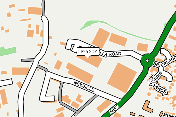
LS25 2DY lies on Isabella Road in Garforth, Leeds. LS25 2DY is located in the Garforth & Swillington electoral ward, within the metropolitan district of Leeds and the English Parliamentary constituency of Elmet and Rothwell. The Sub Integrated Care Board (ICB) Location is NHS West Yorkshire ICB - 15F and the police force is West Yorkshire. This postcode has been in use since July 2006.


GetTheData
Source: OS OpenMap – Local (Ordnance Survey)
Source: OS VectorMap District (Ordnance Survey)
Licence: Open Government Licence (requires attribution)
| Easting | 441533 |
| Northing | 433938 |
| Latitude | 53.800111 |
| Longitude | -1.370905 |
GetTheData
Source: Open Postcode Geo
Licence: Open Government Licence
| Street | Isabella Road |
| Locality | Garforth |
| Town/City | Leeds |
| Country | England |
| Postcode District | LS25 |
➜ See where LS25 is on a map ➜ Where is Garforth? | |
GetTheData
Source: Land Registry Price Paid Data
Licence: Open Government Licence
Elevation or altitude of LS25 2DY as distance above sea level:
| Metres | Feet | |
|---|---|---|
| Elevation | 80m | 262ft |
Elevation is measured from the approximate centre of the postcode, to the nearest point on an OS contour line from OS Terrain 50, which has contour spacing of ten vertical metres.
➜ How high above sea level am I? Find the elevation of your current position using your device's GPS.
GetTheData
Source: Open Postcode Elevation
Licence: Open Government Licence
| Ward | Garforth & Swillington |
| Constituency | Elmet And Rothwell |
GetTheData
Source: ONS Postcode Database
Licence: Open Government Licence
| Aberford Road Newhold (Aberford Road) | East Garforth | 190m |
| Aberford Road Newhold (Aberford Road) | East Garforth | 216m |
| Aberford Rd Brierlands Close (Aberford Road) | East Garforth | 258m |
| Aberford Rd Brierlands Close (Aberford Road) | East Garforth | 261m |
| New Sturton Lane Arundel St (New Sturton Lane) | East Garforth | 435m |
| Garforth Station | 0.8km |
| East Garforth Station | 0.9km |
| Micklefield Station | 3.2km |
GetTheData
Source: NaPTAN
Licence: Open Government Licence
| Median download speed | 10.6Mbps |
| Average download speed | 10.1Mbps |
| Maximum download speed | 11.51Mbps |
| Median upload speed | 1.1Mbps |
| Average upload speed | 1.0Mbps |
| Maximum upload speed | 1.13Mbps |
GetTheData
Source: Ofcom
Licence: Ofcom Terms of Use (requires attribution)
GetTheData
Source: ONS Postcode Database
Licence: Open Government Licence


➜ Get more ratings from the Food Standards Agency
GetTheData
Source: Food Standards Agency
Licence: FSA terms & conditions
| Last Collection | |||
|---|---|---|---|
| Location | Mon-Fri | Sat | Distance |
| Church Lane/Grange Avenue | 17:45 | 10:00 | 1,112m |
| Garforth P.o. | 18:00 | 11:30 | 1,365m |
| By Police Station Lidgett Lane | 18:00 | 10:15 | 1,477m |
GetTheData
Source: Dracos
Licence: Creative Commons Attribution-ShareAlike
The below table lists the International Territorial Level (ITL) codes (formerly Nomenclature of Territorial Units for Statistics (NUTS) codes) and Local Administrative Units (LAU) codes for LS25 2DY:
| ITL 1 Code | Name |
|---|---|
| TLE | Yorkshire and The Humber |
| ITL 2 Code | Name |
| TLE4 | West Yorkshire |
| ITL 3 Code | Name |
| TLE42 | Leeds |
| LAU 1 Code | Name |
| E08000035 | Leeds |
GetTheData
Source: ONS Postcode Directory
Licence: Open Government Licence
The below table lists the Census Output Area (OA), Lower Layer Super Output Area (LSOA), and Middle Layer Super Output Area (MSOA) for LS25 2DY:
| Code | Name | |
|---|---|---|
| OA | E00056973 | |
| LSOA | E01011297 | Leeds 030B |
| MSOA | E02002359 | Leeds 030 |
GetTheData
Source: ONS Postcode Directory
Licence: Open Government Licence
| LS25 2HL | New Hold | 136m |
| LS25 2HN | Ash Terrace | 196m |
| LS25 2LD | New Hold Industrial Estate | 227m |
| LS25 2NU | Brierlands Fold | 276m |
| LS25 2NT | Brierlands Close | 304m |
| LS25 2PG | Silkstone Close | 328m |
| LS25 2HQ | Ash Lane | 334m |
| LS25 2HE | School Terrace | 347m |
| LS25 2NB | Invergarry Close | 355m |
| LS25 2LE | Carisbrooke Lane | 373m |
GetTheData
Source: Open Postcode Geo; Land Registry Price Paid Data
Licence: Open Government Licence