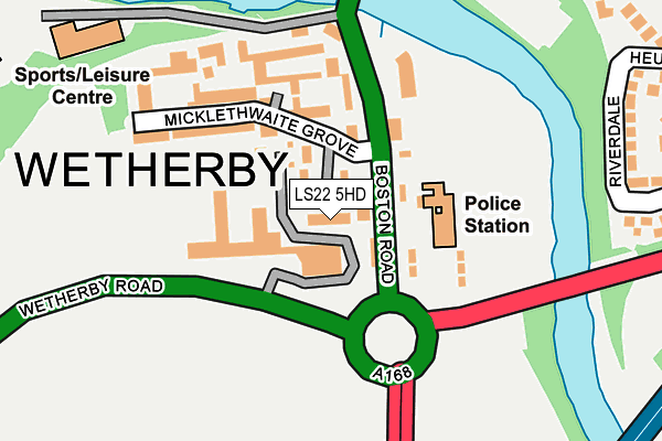
LS22 5HD lies on Grange View in Wetherby. LS22 5HD is located in the Wetherby electoral ward, within the metropolitan district of Leeds and the English Parliamentary constituency of Elmet and Rothwell. The Sub Integrated Care Board (ICB) Location is NHS West Yorkshire ICB - 15F and the police force is West Yorkshire. This postcode has been in use since January 1980.


GetTheData
Source: OS OpenMap – Local (Ordnance Survey)
Source: OS VectorMap District (Ordnance Survey)
Licence: Open Government Licence (requires attribution)
| Easting | 440392 |
| Northing | 447768 |
| Latitude | 53.924479 |
| Longitude | -1.386408 |
GetTheData
Source: Open Postcode Geo
Licence: Open Government Licence
| Street | Grange View |
| Town/City | Wetherby |
| Country | England |
| Postcode District | LS22 |
➜ See where LS22 is on a map ➜ Where is Wetherby? | |
GetTheData
Source: Land Registry Price Paid Data
Licence: Open Government Licence
Elevation or altitude of LS22 5HD as distance above sea level:
| Metres | Feet | |
|---|---|---|
| Elevation | 30m | 98ft |
Elevation is measured from the approximate centre of the postcode, to the nearest point on an OS contour line from OS Terrain 50, which has contour spacing of ten vertical metres.
➜ How high above sea level am I? Find the elevation of your current position using your device's GPS.
GetTheData
Source: Open Postcode Elevation
Licence: Open Government Licence
| Ward | Wetherby |
| Constituency | Elmet And Rothwell |
GetTheData
Source: ONS Postcode Database
Licence: Open Government Licence
| Police Station (Boston Road) | Wetherby | 42m |
| Police Station (Boston Road) | Wetherby | 54m |
| Bus Station (Market Place) | Wetherby | 330m |
| Walton Rd First Avenue (Walton Road) | Wetherby | 409m |
| Walton Road Parsons Green (Walton Road) | Wetherby | 427m |
GetTheData
Source: NaPTAN
Licence: Open Government Licence
| Percentage of properties with Next Generation Access | 100.0% |
| Percentage of properties with Superfast Broadband | 100.0% |
| Percentage of properties with Ultrafast Broadband | 0.0% |
| Percentage of properties with Full Fibre Broadband | 0.0% |
Superfast Broadband is between 30Mbps and 300Mbps
Ultrafast Broadband is > 300Mbps
| Percentage of properties unable to receive 2Mbps | 0.0% |
| Percentage of properties unable to receive 5Mbps | 0.0% |
| Percentage of properties unable to receive 10Mbps | 0.0% |
| Percentage of properties unable to receive 30Mbps | 0.0% |
GetTheData
Source: Ofcom
Licence: Ofcom Terms of Use (requires attribution)
GetTheData
Source: ONS Postcode Database
Licence: Open Government Licence


➜ Get more ratings from the Food Standards Agency
GetTheData
Source: Food Standards Agency
Licence: FSA terms & conditions
| Last Collection | |||
|---|---|---|---|
| Location | Mon-Fri | Sat | Distance |
| Market Place | 18:30 | 12:45 | 355m |
| Walton Road/First Avenue | 18:00 | 12:45 | 431m |
| By Midland Bank North Street | 18:30 | 12:30 | 514m |
GetTheData
Source: Dracos
Licence: Creative Commons Attribution-ShareAlike
The below table lists the International Territorial Level (ITL) codes (formerly Nomenclature of Territorial Units for Statistics (NUTS) codes) and Local Administrative Units (LAU) codes for LS22 5HD:
| ITL 1 Code | Name |
|---|---|
| TLE | Yorkshire and The Humber |
| ITL 2 Code | Name |
| TLE4 | West Yorkshire |
| ITL 3 Code | Name |
| TLE42 | Leeds |
| LAU 1 Code | Name |
| E08000035 | Leeds |
GetTheData
Source: ONS Postcode Directory
Licence: Open Government Licence
The below table lists the Census Output Area (OA), Lower Layer Super Output Area (LSOA), and Middle Layer Super Output Area (MSOA) for LS22 5HD:
| Code | Name | |
|---|---|---|
| OA | E00170579 | |
| LSOA | E01011704 | Leeds 002C |
| MSOA | E02002331 | Leeds 002 |
GetTheData
Source: ONS Postcode Directory
Licence: Open Government Licence
| LS22 5HB | Micklethwaite View | 47m |
| LS22 5HA | Boston Road | 91m |
| LS22 5LB | Micklethwaite Mews | 101m |
| LS22 5LA | Micklethwaite Grove | 163m |
| LS22 5LD | Micklethwaite Steps | 163m |
| LS22 5GZ | Bridge Court | 174m |
| LS22 5LL | Micklethwaite Stables | 176m |
| LS22 6NB | Scott Lane | 269m |
| LS22 6RP | Riverdale | 286m |
| LS22 6AN | Bridgefoot | 299m |
GetTheData
Source: Open Postcode Geo; Land Registry Price Paid Data
Licence: Open Government Licence