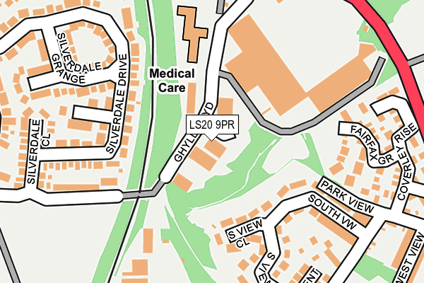
LS20 9PR is located in the Guiseley & Rawdon electoral ward, within the metropolitan district of Leeds and the English Parliamentary constituency of Pudsey. The Sub Integrated Care Board (ICB) Location is NHS West Yorkshire ICB - 15F and the police force is West Yorkshire. This postcode has been in use since June 1997.


GetTheData
Source: OS OpenMap – Local (Ordnance Survey)
Source: OS VectorMap District (Ordnance Survey)
Licence: Open Government Licence (requires attribution)
| Easting | 419464 |
| Northing | 441336 |
| Latitude | 53.867874 |
| Longitude | -1.705493 |
GetTheData
Source: Open Postcode Geo
Licence: Open Government Licence
| Country | England |
| Postcode District | LS20 |
➜ See where LS20 is on a map ➜ Where is Guiseley? | |
GetTheData
Source: Land Registry Price Paid Data
Licence: Open Government Licence
Elevation or altitude of LS20 9PR as distance above sea level:
| Metres | Feet | |
|---|---|---|
| Elevation | 120m | 394ft |
Elevation is measured from the approximate centre of the postcode, to the nearest point on an OS contour line from OS Terrain 50, which has contour spacing of ten vertical metres.
➜ How high above sea level am I? Find the elevation of your current position using your device's GPS.
GetTheData
Source: Open Postcode Elevation
Licence: Open Government Licence
| Ward | Guiseley & Rawdon |
| Constituency | Pudsey |
GetTheData
Source: ONS Postcode Database
Licence: Open Government Licence
| New Rd Nunroyd Avenue (New Road) | Guiseley | 286m |
| Leeds Rd Ghyll Road (Leeds Road) | Guiseley | 302m |
| New Rd Nunroyd Park (New Road) | Westfield | 305m |
| New Rd Nunroyd Park (New Road) | Westfield | 350m |
| Leeds Road The Green (Leeds Road) | Guiseley | 377m |
| Guiseley Station | 1.1km |
| Apperley Bridge Station | 2.9km |
| Menston Station | 3.4km |
GetTheData
Source: NaPTAN
Licence: Open Government Licence
GetTheData
Source: ONS Postcode Database
Licence: Open Government Licence


➜ Get more ratings from the Food Standards Agency
GetTheData
Source: Food Standards Agency
Licence: FSA terms & conditions
| Last Collection | |||
|---|---|---|---|
| Location | Mon-Fri | Sat | Distance |
| Silverdale Avenue/Drive | 17:30 | 11:00 | 342m |
| Town Hall | 18:00 | 11:45 | 479m |
| Wm Morrisons | 17:30 | 12:00 | 662m |
GetTheData
Source: Dracos
Licence: Creative Commons Attribution-ShareAlike
The below table lists the International Territorial Level (ITL) codes (formerly Nomenclature of Territorial Units for Statistics (NUTS) codes) and Local Administrative Units (LAU) codes for LS20 9PR:
| ITL 1 Code | Name |
|---|---|
| TLE | Yorkshire and The Humber |
| ITL 2 Code | Name |
| TLE4 | West Yorkshire |
| ITL 3 Code | Name |
| TLE42 | Leeds |
| LAU 1 Code | Name |
| E08000035 | Leeds |
GetTheData
Source: ONS Postcode Directory
Licence: Open Government Licence
The below table lists the Census Output Area (OA), Lower Layer Super Output Area (LSOA), and Middle Layer Super Output Area (MSOA) for LS20 9PR:
| Code | Name | |
|---|---|---|
| OA | E00056751 | |
| LSOA | E01011272 | Leeds 009D |
| MSOA | E02002338 | Leeds 009 |
GetTheData
Source: ONS Postcode Directory
Licence: Open Government Licence
| LS20 9NE | West Side Retail Park | 125m |
| LS19 7JB | South View Close | 147m |
| LS20 9LT | Ghyll Royd | 178m |
| LS20 8BE | Silverdale Drive | 181m |
| LS19 7JA | South View Crescent | 200m |
| LS19 7HZ | Park View | 209m |
| LS19 7JD | South View | 210m |
| LS19 7WA | Fairfax Grove | 215m |
| LS20 9BP | Ghyll Royd | 229m |
| LS20 8PX | Silverdale Grange | 251m |
GetTheData
Source: Open Postcode Geo; Land Registry Price Paid Data
Licence: Open Government Licence