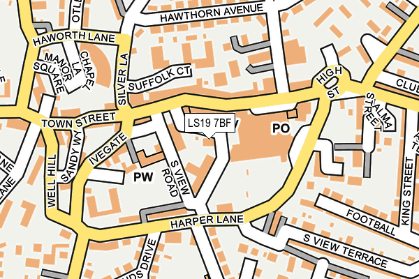
LS19 7BF lies on South View Road in Yeadon, Leeds. LS19 7BF is located in the Otley & Yeadon electoral ward, within the metropolitan district of Leeds and the English Parliamentary constituency of Leeds North West. The Sub Integrated Care Board (ICB) Location is NHS West Yorkshire ICB - 15F and the police force is West Yorkshire. This postcode has been in use since December 1997.


GetTheData
Source: OS OpenMap – Local (Ordnance Survey)
Source: OS VectorMap District (Ordnance Survey)
Licence: Open Government Licence (requires attribution)
| Easting | 420894 |
| Northing | 441094 |
| Latitude | 53.865644 |
| Longitude | -1.683764 |
GetTheData
Source: Open Postcode Geo
Licence: Open Government Licence
| Street | South View Road |
| Locality | Yeadon |
| Town/City | Leeds |
| Country | England |
| Postcode District | LS19 |
➜ See where LS19 is on a map ➜ Where is Yeadon? | |
GetTheData
Source: Land Registry Price Paid Data
Licence: Open Government Licence
Elevation or altitude of LS19 7BF as distance above sea level:
| Metres | Feet | |
|---|---|---|
| Elevation | 180m | 591ft |
Elevation is measured from the approximate centre of the postcode, to the nearest point on an OS contour line from OS Terrain 50, which has contour spacing of ten vertical metres.
➜ How high above sea level am I? Find the elevation of your current position using your device's GPS.
GetTheData
Source: Open Postcode Elevation
Licence: Open Government Licence
| Ward | Otley & Yeadon |
| Constituency | Leeds North West |
GetTheData
Source: ONS Postcode Database
Licence: Open Government Licence
CLIFFE HOUSE, SOUTH VIEW ROAD, YEADON, LEEDS, LS19 7BF 2023 31 JUL £420,000 |
CLIFFE HOUSE, SOUTH VIEW ROAD, YEADON, LEEDS, LS19 7BF 2023 18 JAN £330,000 |
CLIFFE HOUSE, SOUTH VIEW ROAD, YEADON, LEEDS, LS19 7BF 1997 3 JUN £165,087 |
GetTheData
Source: HM Land Registry Price Paid Data
Licence: Contains HM Land Registry data © Crown copyright and database right 2025. This data is licensed under the Open Government Licence v3.0.
| Town Hall South View Road (Town Hall Square) | Yeadon | 78m |
| Harper Lane | Yeadon | 118m |
| High Street Harper Ln (High Street) | Yeadon | 139m |
| Harper Lane Brooklands Cres (Harper Lane) | Yeadon | 140m |
| Silver Lane Suffolk Court (Silver Lane) | Yeadon | 161m |
| Guiseley Station | 2.4km |
| Apperley Bridge Station | 3km |
| Horsforth Station | 4km |
GetTheData
Source: NaPTAN
Licence: Open Government Licence
GetTheData
Source: ONS Postcode Database
Licence: Open Government Licence


➜ Get more ratings from the Food Standards Agency
GetTheData
Source: Food Standards Agency
Licence: FSA terms & conditions
| Last Collection | |||
|---|---|---|---|
| Location | Mon-Fri | Sat | Distance |
| National Westminster | 16:00 | 12:15 | 125m |
| Yeadon P.o. | 17:30 | 12:15 | 128m |
| Royal Mail Aireborough | 17:15 | 12:30 | 515m |
GetTheData
Source: Dracos
Licence: Creative Commons Attribution-ShareAlike
The below table lists the International Territorial Level (ITL) codes (formerly Nomenclature of Territorial Units for Statistics (NUTS) codes) and Local Administrative Units (LAU) codes for LS19 7BF:
| ITL 1 Code | Name |
|---|---|
| TLE | Yorkshire and The Humber |
| ITL 2 Code | Name |
| TLE4 | West Yorkshire |
| ITL 3 Code | Name |
| TLE42 | Leeds |
| LAU 1 Code | Name |
| E08000035 | Leeds |
GetTheData
Source: ONS Postcode Directory
Licence: Open Government Licence
The below table lists the Census Output Area (OA), Lower Layer Super Output Area (LSOA), and Middle Layer Super Output Area (MSOA) for LS19 7BF:
| Code | Name | |
|---|---|---|
| OA | E00056753 | |
| LSOA | E01011274 | Leeds 010C |
| MSOA | E02002339 | Leeds 010 |
GetTheData
Source: ONS Postcode Directory
Licence: Open Government Licence
| LS19 7PP | High Street | 49m |
| LS19 7SP | High Street | 67m |
| LS19 7JN | Suffolk Court | 96m |
| LS19 7RG | Chapel Hill | 118m |
| LS19 7ZD | Marshall Court | 131m |
| LS19 7RE | Ivegate | 133m |
| LS19 7RP | Harper Terrace | 139m |
| LS19 7QW | Harper Rock | 153m |
| LS19 7QP | Harper Lane | 165m |
| LS19 7EQ | Town Street | 169m |
GetTheData
Source: Open Postcode Geo; Land Registry Price Paid Data
Licence: Open Government Licence