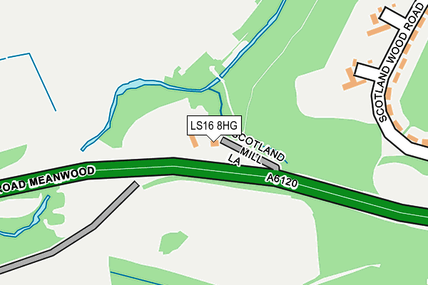
LS16 8HG is located in the Alwoodley electoral ward, within the metropolitan district of Leeds and the English Parliamentary constituency of Leeds North East. The Sub Integrated Care Board (ICB) Location is NHS West Yorkshire ICB - 15F and the police force is West Yorkshire. This postcode has been in use since June 2009.


GetTheData
Source: OS OpenMap – Local (Ordnance Survey)
Source: OS VectorMap District (Ordnance Survey)
Licence: Open Government Licence (requires attribution)
| Easting | 428552 |
| Northing | 438646 |
| Latitude | 53.843279 |
| Longitude | -1.567544 |
GetTheData
Source: Open Postcode Geo
Licence: Open Government Licence
| Country | England |
| Postcode District | LS16 |
➜ See where LS16 is on a map ➜ Where is Leeds? | |
GetTheData
Source: Land Registry Price Paid Data
Licence: Open Government Licence
Elevation or altitude of LS16 8HG as distance above sea level:
| Metres | Feet | |
|---|---|---|
| Elevation | 90m | 295ft |
Elevation is measured from the approximate centre of the postcode, to the nearest point on an OS contour line from OS Terrain 50, which has contour spacing of ten vertical metres.
➜ How high above sea level am I? Find the elevation of your current position using your device's GPS.
GetTheData
Source: Open Postcode Elevation
Licence: Open Government Licence
| Ward | Alwoodley |
| Constituency | Leeds North East |
GetTheData
Source: ONS Postcode Database
Licence: Open Government Licence
| Ring Rd Tongue Lane (Ring Road Meanwood) | Meanwood | 243m |
| Ring Rd Scotland Mill Road (Ring Road Meanwood) | Meanwood | 249m |
| Black Moor Road Scotland Wood Rd (Black Moor Road) | Moortown | 543m |
| Black Moor Road Scotland Wood Rd (Black Moor Road) | Moortown | 549m |
| Valley Farm (Ring Road Adel) | Weetwood | 565m |
| Headingley Station | 3.3km |
| Burley Park Station | 3.5km |
| Horsforth Station | 4.2km |
GetTheData
Source: NaPTAN
Licence: Open Government Licence
GetTheData
Source: ONS Postcode Database
Licence: Open Government Licence


➜ Get more ratings from the Food Standards Agency
GetTheData
Source: Food Standards Agency
Licence: FSA terms & conditions
| Last Collection | |||
|---|---|---|---|
| Location | Mon-Fri | Sat | Distance |
| Alderton Heights | 17:45 | 11:15 | 271m |
| Woodlea Approach | 17:30 | 11:30 | 628m |
| Upper Meanwood | 17:30 | 11:30 | 842m |
GetTheData
Source: Dracos
Licence: Creative Commons Attribution-ShareAlike
The below table lists the International Territorial Level (ITL) codes (formerly Nomenclature of Territorial Units for Statistics (NUTS) codes) and Local Administrative Units (LAU) codes for LS16 8HG:
| ITL 1 Code | Name |
|---|---|
| TLE | Yorkshire and The Humber |
| ITL 2 Code | Name |
| TLE4 | West Yorkshire |
| ITL 3 Code | Name |
| TLE42 | Leeds |
| LAU 1 Code | Name |
| E08000035 | Leeds |
GetTheData
Source: ONS Postcode Directory
Licence: Open Government Licence
The below table lists the Census Output Area (OA), Lower Layer Super Output Area (LSOA), and Middle Layer Super Output Area (MSOA) for LS16 8HG:
| Code | Name | |
|---|---|---|
| OA | E00058263 | |
| LSOA | E01011560 | Leeds 018D |
| MSOA | E02002347 | Leeds 018 |
GetTheData
Source: ONS Postcode Directory
Licence: Open Government Licence
| LS17 5LR | Scotland Wood Road | 268m |
| LS6 4RX | Caraway Drive | 316m |
| LS6 4RY | Caraway Court | 330m |
| LS6 4RU | Lawson Wood Court | 330m |
| LS6 4RZ | Caraway Mews | 342m |
| LS6 4RW | Lawson Wood Drive | 351m |
| LS6 4RT | Sandlewood Crescent | 351m |
| LS6 4SU | Woodlea Avenue | 357m |
| LS17 5LG | Alderton Bank | 379m |
| LS6 4QS | Deighton View | 386m |
GetTheData
Source: Open Postcode Geo; Land Registry Price Paid Data
Licence: Open Government Licence