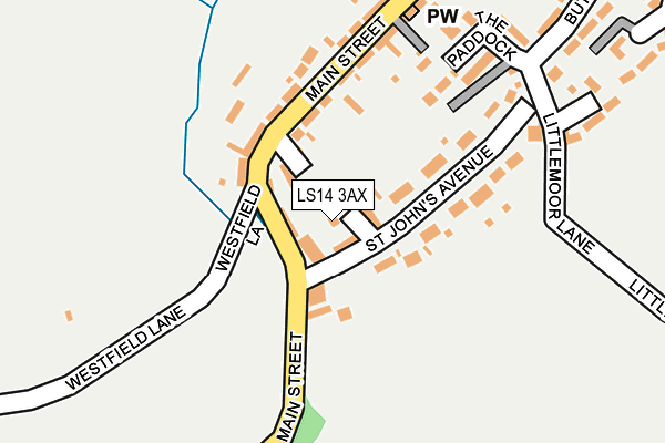
LS14 3AX lies on St Johns Court in Thorner, Leeds. LS14 3AX is located in the Harewood electoral ward, within the metropolitan district of Leeds and the English Parliamentary constituency of Elmet and Rothwell. The Sub Integrated Care Board (ICB) Location is NHS West Yorkshire ICB - 15F and the police force is West Yorkshire. This postcode has been in use since January 1991.


GetTheData
Source: OS OpenMap – Local (Ordnance Survey)
Source: OS VectorMap District (Ordnance Survey)
Licence: Open Government Licence (requires attribution)
| Easting | 437613 |
| Northing | 440048 |
| Latitude | 53.855305 |
| Longitude | -1.429669 |
GetTheData
Source: Open Postcode Geo
Licence: Open Government Licence
| Street | St Johns Court |
| Locality | Thorner |
| Town/City | Leeds |
| Country | England |
| Postcode District | LS14 |
➜ See where LS14 is on a map ➜ Where is Thorner? | |
GetTheData
Source: Land Registry Price Paid Data
Licence: Open Government Licence
Elevation or altitude of LS14 3AX as distance above sea level:
| Metres | Feet | |
|---|---|---|
| Elevation | 90m | 295ft |
Elevation is measured from the approximate centre of the postcode, to the nearest point on an OS contour line from OS Terrain 50, which has contour spacing of ten vertical metres.
➜ How high above sea level am I? Find the elevation of your current position using your device's GPS.
GetTheData
Source: Open Postcode Elevation
Licence: Open Government Licence
| Ward | Harewood |
| Constituency | Elmet And Rothwell |
GetTheData
Source: ONS Postcode Database
Licence: Open Government Licence
| Main Street St Johns Ave (Main Street) | Thorner | 44m |
| Main Street St Johns Ave (Main Street) | Thorner | 86m |
| Main Street | Thorner | 245m |
| Main Street Prospect Court (Main Street) | Thorner | 281m |
| Lower Sandhills | Thorner | 631m |
GetTheData
Source: NaPTAN
Licence: Open Government Licence
| Percentage of properties with Next Generation Access | 100.0% |
| Percentage of properties with Superfast Broadband | 100.0% |
| Percentage of properties with Ultrafast Broadband | 0.0% |
| Percentage of properties with Full Fibre Broadband | 0.0% |
Superfast Broadband is between 30Mbps and 300Mbps
Ultrafast Broadband is > 300Mbps
| Median download speed | 26.1Mbps |
| Average download speed | 27.2Mbps |
| Maximum download speed | 47.06Mbps |
| Median upload speed | 2.0Mbps |
| Average upload speed | 3.8Mbps |
| Maximum upload speed | 7.32Mbps |
| Percentage of properties unable to receive 2Mbps | 0.0% |
| Percentage of properties unable to receive 5Mbps | 0.0% |
| Percentage of properties unable to receive 10Mbps | 0.0% |
| Percentage of properties unable to receive 30Mbps | 0.0% |
GetTheData
Source: Ofcom
Licence: Ofcom Terms of Use (requires attribution)
Estimated total energy consumption in LS14 3AX by fuel type, 2015.
| Consumption (kWh) | 273,542 |
|---|---|
| Meter count | 23 |
| Mean (kWh/meter) | 11,893 |
| Median (kWh/meter) | 12,220 |
| Consumption (kWh) | 40,279 |
|---|---|
| Meter count | 18 |
| Mean (kWh/meter) | 2,238 |
| Median (kWh/meter) | 1,944 |
GetTheData
Source: Postcode level gas estimates: 2015 (experimental)
Source: Postcode level electricity estimates: 2015 (experimental)
Licence: Open Government Licence
GetTheData
Source: ONS Postcode Database
Licence: Open Government Licence


➜ Get more ratings from the Food Standards Agency
GetTheData
Source: Food Standards Agency
Licence: FSA terms & conditions
| Last Collection | |||
|---|---|---|---|
| Location | Mon-Fri | Sat | Distance |
| Thorner P.o. | 18:00 | 09:30 | 198m |
| Sandhills | 18:15 | 09:00 | 530m |
| St Peters Church. Church View | 17:45 | 09:00 | 584m |
GetTheData
Source: Dracos
Licence: Creative Commons Attribution-ShareAlike
The below table lists the International Territorial Level (ITL) codes (formerly Nomenclature of Territorial Units for Statistics (NUTS) codes) and Local Administrative Units (LAU) codes for LS14 3AX:
| ITL 1 Code | Name |
|---|---|
| TLE | Yorkshire and The Humber |
| ITL 2 Code | Name |
| TLE4 | West Yorkshire |
| ITL 3 Code | Name |
| TLE42 | Leeds |
| LAU 1 Code | Name |
| E08000035 | Leeds |
GetTheData
Source: ONS Postcode Directory
Licence: Open Government Licence
The below table lists the Census Output Area (OA), Lower Layer Super Output Area (LSOA), and Middle Layer Super Output Area (MSOA) for LS14 3AX:
| Code | Name | |
|---|---|---|
| OA | E00056978 | |
| LSOA | E01011310 | Leeds 030D |
| MSOA | E02002359 | Leeds 030 |
GetTheData
Source: ONS Postcode Directory
Licence: Open Government Licence
| LS14 3BU | Main Street | 110m |
| LS14 3BZ | St Johns Avenue | 132m |
| LS14 3BX | Camp Square | 164m |
| LS14 3JB | The Paddock | 189m |
| LS14 3BT | Butts Garth Walk | 219m |
| LS14 3DH | Littlemoor Lane | 248m |
| LS14 3DY | Virginia Terrace | 292m |
| LS14 3DA | Butts Garth | 294m |
| LS14 3LA | Butts Garth Court | 298m |
| LS14 3JW | Prospect Court | 307m |
GetTheData
Source: Open Postcode Geo; Land Registry Price Paid Data
Licence: Open Government Licence