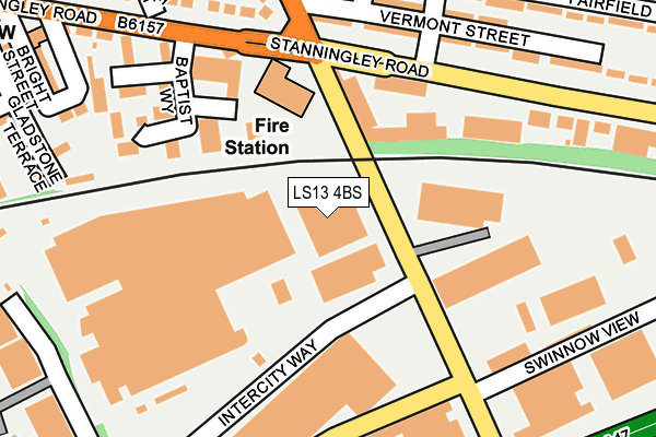
LS13 4BS is located in the Pudsey electoral ward, within the metropolitan district of Leeds and the English Parliamentary constituency of Pudsey. The Sub Integrated Care Board (ICB) Location is NHS West Yorkshire ICB - 15F and the police force is West Yorkshire. This postcode has been in use since October 2010.


GetTheData
Source: OS OpenMap – Local (Ordnance Survey)
Source: OS VectorMap District (Ordnance Survey)
Licence: Open Government Licence (requires attribution)
| Easting | 423201 |
| Northing | 434509 |
| Latitude | 53.806362 |
| Longitude | -1.649178 |
GetTheData
Source: Open Postcode Geo
Licence: Open Government Licence
| Country | England |
| Postcode District | LS13 |
➜ See where LS13 is on a map ➜ Where is Leeds? | |
GetTheData
Source: Land Registry Price Paid Data
Licence: Open Government Licence
Elevation or altitude of LS13 4BS as distance above sea level:
| Metres | Feet | |
|---|---|---|
| Elevation | 110m | 361ft |
Elevation is measured from the approximate centre of the postcode, to the nearest point on an OS contour line from OS Terrain 50, which has contour spacing of ten vertical metres.
➜ How high above sea level am I? Find the elevation of your current position using your device's GPS.
GetTheData
Source: Open Postcode Elevation
Licence: Open Government Licence
| Ward | Pudsey |
| Constituency | Pudsey |
GetTheData
Source: ONS Postcode Database
Licence: Open Government Licence
| Swinnow Lane Stanningley Rd (Swinnow Lane) | Swinnow | 65m |
| Swinnow Lane Stanningley Rd (Swinnow Lane) | Swinnow | 113m |
| Stanningley Road Fairfield Ave (Stanningley Road) | Bramley | 191m |
| Stanningley Rd Baptist Way (Stanningley Road) | Stanningley | 214m |
| Stanningley Rd Baptist Way (Stanningley Road) | Stanningley | 239m |
| Bramley (West Yorks) Station | 0.8km |
| New Pudsey Station | 2.1km |
| Kirkstall Forge Station | 2.6km |
GetTheData
Source: NaPTAN
Licence: Open Government Licence
GetTheData
Source: ONS Postcode Database
Licence: Open Government Licence


➜ Get more ratings from the Food Standards Agency
GetTheData
Source: Food Standards Agency
Licence: FSA terms & conditions
| Last Collection | |||
|---|---|---|---|
| Location | Mon-Fri | Sat | Distance |
| Fairfield Estate P.o. | 17:30 | 11:45 | 364m |
| Bradley Hill | 18:00 | 11:00 | 405m |
| 2 Swinnow Avenue/Lane | 17:30 | 11:30 | 407m |
GetTheData
Source: Dracos
Licence: Creative Commons Attribution-ShareAlike
The below table lists the International Territorial Level (ITL) codes (formerly Nomenclature of Territorial Units for Statistics (NUTS) codes) and Local Administrative Units (LAU) codes for LS13 4BS:
| ITL 1 Code | Name |
|---|---|
| TLE | Yorkshire and The Humber |
| ITL 2 Code | Name |
| TLE4 | West Yorkshire |
| ITL 3 Code | Name |
| TLE42 | Leeds |
| LAU 1 Code | Name |
| E08000035 | Leeds |
GetTheData
Source: ONS Postcode Directory
Licence: Open Government Licence
The below table lists the Census Output Area (OA), Lower Layer Super Output Area (LSOA), and Middle Layer Super Output Area (MSOA) for LS13 4BS:
| Code | Name | |
|---|---|---|
| OA | E00058416 | |
| LSOA | E01011596 | Leeds 062D |
| MSOA | E02002391 | Leeds 062 |
GetTheData
Source: ONS Postcode Directory
Licence: Open Government Licence
| LS13 3HZ | Stanningley Road | 186m |
| LS28 6LA | Baptist Way | 194m |
| LS28 6LB | Jordan Road | 195m |
| LS13 3HY | Vermont Street | 207m |
| LS13 4TY | Swinnow Lane | 216m |
| LS13 3HX | Swinnow Lane | 217m |
| LS28 6LD | Magdalin Drive | 224m |
| LS13 3HT | Randolph Street | 251m |
| LS28 6PF | Gladstone Court | 252m |
| LS28 6NY | Swinnow Lane | 259m |
GetTheData
Source: Open Postcode Geo; Land Registry Price Paid Data
Licence: Open Government Licence