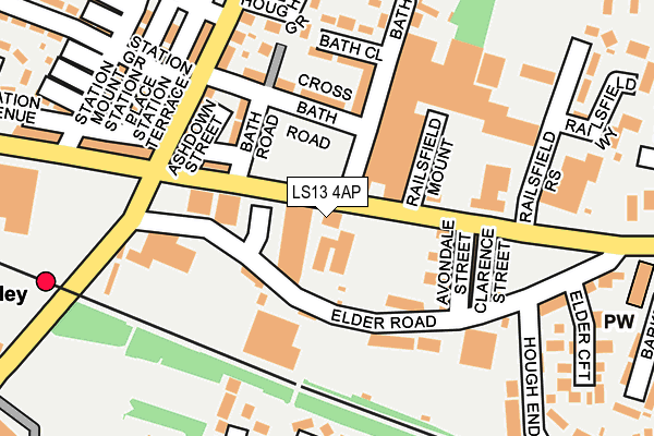
LS13 4AP lies on Stanningley Road in Leeds. LS13 4AP is located in the Armley electoral ward, within the metropolitan district of Leeds and the English Parliamentary constituency of Leeds West. The Sub Integrated Care Board (ICB) Location is NHS West Yorkshire ICB - 15F and the police force is West Yorkshire. This postcode has been in use since January 1980.


GetTheData
Source: OS OpenMap – Local (Ordnance Survey)
Source: OS VectorMap District (Ordnance Survey)
Licence: Open Government Licence (requires attribution)
| Easting | 424235 |
| Northing | 434464 |
| Latitude | 53.805911 |
| Longitude | -1.633481 |
GetTheData
Source: Open Postcode Geo
Licence: Open Government Licence
| Street | Stanningley Road |
| Town/City | Leeds |
| Country | England |
| Postcode District | LS13 |
➜ See where LS13 is on a map ➜ Where is Leeds? | |
GetTheData
Source: Land Registry Price Paid Data
Licence: Open Government Licence
Elevation or altitude of LS13 4AP as distance above sea level:
| Metres | Feet | |
|---|---|---|
| Elevation | 120m | 394ft |
Elevation is measured from the approximate centre of the postcode, to the nearest point on an OS contour line from OS Terrain 50, which has contour spacing of ten vertical metres.
➜ How high above sea level am I? Find the elevation of your current position using your device's GPS.
GetTheData
Source: Open Postcode Elevation
Licence: Open Government Licence
| Ward | Armley |
| Constituency | Leeds West |
GetTheData
Source: ONS Postcode Database
Licence: Open Government Licence
473, STANNINGLEY ROAD, LEEDS, LS13 4AP 1999 30 JUL £85,000 |
GetTheData
Source: HM Land Registry Price Paid Data
Licence: Contains HM Land Registry data © Crown copyright and database right 2025. This data is licensed under the Open Government Licence v3.0.
| Stanningley Road Railsfield Mount (Stanningley Road) | Bramley | 83m |
| Stanningley Road Railsfield Mount (Stanningley Road) | Bramley | 158m |
| Stanningley Road Station Mount (Stanningley Road) | Bramley | 259m |
| Stanningley Road Station Mount (Stanningley Road) | Bramley | 307m |
| Swinnow Rd Sunnyside Road (Swinnow Road) | Swinnow | 327m |
| Bramley (West Yorks) Station | 0.3km |
| Kirkstall Forge Station | 2.1km |
| Headingley Station | 2.9km |
GetTheData
Source: NaPTAN
Licence: Open Government Licence
GetTheData
Source: ONS Postcode Database
Licence: Open Government Licence


➜ Get more ratings from the Food Standards Agency
GetTheData
Source: Food Standards Agency
Licence: FSA terms & conditions
| Last Collection | |||
|---|---|---|---|
| Location | Mon-Fri | Sat | Distance |
| Hough Lane | 17:30 | 11:00 | 169m |
| Elder Road/Hough End Lane | 17:30 | 11:00 | 193m |
| Rossfield Approach | 17:30 | 11:00 | 409m |
GetTheData
Source: Dracos
Licence: Creative Commons Attribution-ShareAlike
The below table lists the International Territorial Level (ITL) codes (formerly Nomenclature of Territorial Units for Statistics (NUTS) codes) and Local Administrative Units (LAU) codes for LS13 4AP:
| ITL 1 Code | Name |
|---|---|
| TLE | Yorkshire and The Humber |
| ITL 2 Code | Name |
| TLE4 | West Yorkshire |
| ITL 3 Code | Name |
| TLE42 | Leeds |
| LAU 1 Code | Name |
| E08000035 | Leeds |
GetTheData
Source: ONS Postcode Directory
Licence: Open Government Licence
The below table lists the Census Output Area (OA), Lower Layer Super Output Area (LSOA), and Middle Layer Super Output Area (MSOA) for LS13 4AP:
| Code | Name | |
|---|---|---|
| OA | E00056863 | |
| LSOA | E01011287 | Leeds 067B |
| MSOA | E02002396 | Leeds 067 |
GetTheData
Source: ONS Postcode Directory
Licence: Open Government Licence
| LS13 3BA | Stanningley Road | 67m |
| LS13 4BH | Elder Place | 111m |
| LS13 4BQ | Elder Mount | 114m |
| LS13 4DB | Elder Road | 117m |
| LS13 3BS | Stanningley Road | 122m |
| LS13 3BP | Bath Road | 127m |
| LS13 4DL | Elder Road | 137m |
| LS13 4DE | Avondale Street | 142m |
| LS13 3BE | Bath Close | 151m |
| LS13 4DD | Clarence Street | 160m |
GetTheData
Source: Open Postcode Geo; Land Registry Price Paid Data
Licence: Open Government Licence