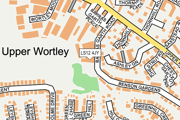
LS12 4JY is located in the Farnley & Wortley electoral ward, within the metropolitan district of Leeds and the English Parliamentary constituency of Leeds West. The Sub Integrated Care Board (ICB) Location is NHS West Yorkshire ICB - 15F and the police force is West Yorkshire. This postcode has been in use since June 2001.


GetTheData
Source: OS OpenMap – Local (Ordnance Survey)
Source: OS VectorMap District (Ordnance Survey)
Licence: Open Government Licence (requires attribution)
| Easting | 426771 |
| Northing | 432761 |
| Latitude | 53.790481 |
| Longitude | -1.595121 |
GetTheData
Source: Open Postcode Geo
Licence: Open Government Licence
| Country | England |
| Postcode District | LS12 |
➜ See where LS12 is on a map ➜ Where is Leeds? | |
GetTheData
Source: Land Registry Price Paid Data
Licence: Open Government Licence
Elevation or altitude of LS12 4JY as distance above sea level:
| Metres | Feet | |
|---|---|---|
| Elevation | 100m | 328ft |
Elevation is measured from the approximate centre of the postcode, to the nearest point on an OS contour line from OS Terrain 50, which has contour spacing of ten vertical metres.
➜ How high above sea level am I? Find the elevation of your current position using your device's GPS.
GetTheData
Source: Open Postcode Elevation
Licence: Open Government Licence
| Ward | Farnley & Wortley |
| Constituency | Leeds West |
GetTheData
Source: ONS Postcode Database
Licence: Open Government Licence
| Upper Wortley Rd Thornhill Road (Upper Wortley Road) | Wortley | 182m |
| Upper Wortley Rd Thornhill Road (Upper Wortley Road) | Wortley | 210m |
| Cross Lane Tong Rd (Cross Lane) | Wortley | 248m |
| Cross Lane Tong Rd (Cross Lane) | Wortley | 264m |
| Upper Wortley Rd Tong Road (Upper Wortley Road) | Armley | 284m |
| Cottingley Station | 2.6km |
| Burley Park Station | 2.7km |
| Headingley Station | 3.1km |
GetTheData
Source: NaPTAN
Licence: Open Government Licence
GetTheData
Source: ONS Postcode Database
Licence: Open Government Licence


➜ Get more ratings from the Food Standards Agency
GetTheData
Source: Food Standards Agency
Licence: FSA terms & conditions
| Last Collection | |||
|---|---|---|---|
| Location | Mon-Fri | Sat | Distance |
| Wortley P.o. | 17:30 | 12:00 | 320m |
| Green Hill Lane | 18:00 | 12:00 | 331m |
| 3 Dixon Lane/Lower Wortley Road | 17:30 | 11:30 | 453m |
GetTheData
Source: Dracos
Licence: Creative Commons Attribution-ShareAlike
The below table lists the International Territorial Level (ITL) codes (formerly Nomenclature of Territorial Units for Statistics (NUTS) codes) and Local Administrative Units (LAU) codes for LS12 4JY:
| ITL 1 Code | Name |
|---|---|
| TLE | Yorkshire and The Humber |
| ITL 2 Code | Name |
| TLE4 | West Yorkshire |
| ITL 3 Code | Name |
| TLE42 | Leeds |
| LAU 1 Code | Name |
| E08000035 | Leeds |
GetTheData
Source: ONS Postcode Directory
Licence: Open Government Licence
The below table lists the Census Output Area (OA), Lower Layer Super Output Area (LSOA), and Middle Layer Super Output Area (MSOA) for LS12 4JY:
| Code | Name | |
|---|---|---|
| OA | E00059124 | |
| LSOA | E01011732 | Leeds 081C |
| MSOA | E02002410 | Leeds 081 |
GetTheData
Source: ONS Postcode Directory
Licence: Open Government Licence
| LS12 4JW | Barras Garth Road | 97m |
| LS12 4JX | Thornhill Croft | 117m |
| LS12 4JP | Barras Terrace | 146m |
| LS12 4HU | Green Hill Croft | 150m |
| LS12 4JS | Barras Street | 156m |
| LS12 4JN | Upper Wortley Road | 159m |
| LS12 4JR | Barras Place | 165m |
| LS12 4HF | Green Hill Chase | 181m |
| LS12 4JZ | Benson Gardens | 184m |
| LS12 4HE | Green Hill Gardens | 185m |
GetTheData
Source: Open Postcode Geo; Land Registry Price Paid Data
Licence: Open Government Licence