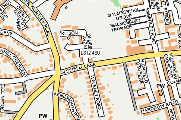
LS12 4EU is located in the Farnley & Wortley electoral ward, within the metropolitan district of Leeds and the English Parliamentary constituency of Leeds West. The Sub Integrated Care Board (ICB) Location is NHS West Yorkshire ICB - 15F and the police force is West Yorkshire. This postcode has been in use since January 1980.


GetTheData
Source: OS OpenMap – Local (Ordnance Survey)
Source: OS VectorMap District (Ordnance Survey)
Licence: Open Government Licence (requires attribution)
| Easting | 427264 |
| Northing | 432572 |
| Latitude | 53.788773 |
| Longitude | -1.587658 |
GetTheData
Source: Open Postcode Geo
Licence: Open Government Licence
| Country | England |
| Postcode District | LS12 |
➜ See where LS12 is on a map ➜ Where is Leeds? | |
GetTheData
Source: Land Registry Price Paid Data
Licence: Open Government Licence
Elevation or altitude of LS12 4EU as distance above sea level:
| Metres | Feet | |
|---|---|---|
| Elevation | 70m | 230ft |
Elevation is measured from the approximate centre of the postcode, to the nearest point on an OS contour line from OS Terrain 50, which has contour spacing of ten vertical metres.
➜ How high above sea level am I? Find the elevation of your current position using your device's GPS.
GetTheData
Source: Open Postcode Elevation
Licence: Open Government Licence
| Ward | Farnley & Wortley |
| Constituency | Leeds West |
GetTheData
Source: ONS Postcode Database
Licence: Open Government Licence
| Oldfield Lane Waveney Rd (Oldfield Lane) | Wortley | 71m |
| Upper Wortley Rd Five Lane Ends (Upper Wortley Road) | Wortley | 110m |
| Upper Wortley Rd Five Lane Ends (Upper Wortley Road) | Wortley | 117m |
| Oldfield Ln Highfields Gardens (Oldfield Lane) | Wortley | 126m |
| Green Hill Lane Upper Wortley Rd (Green Hill Lane) | Wortley | 147m |
| Cottingley Station | 2.3km |
| Burley Park Station | 2.7km |
| Leeds Station | 2.7km |
GetTheData
Source: NaPTAN
Licence: Open Government Licence
GetTheData
Source: ONS Postcode Database
Licence: Open Government Licence


➜ Get more ratings from the Food Standards Agency
GetTheData
Source: Food Standards Agency
Licence: FSA terms & conditions
| Last Collection | |||
|---|---|---|---|
| Location | Mon-Fri | Sat | Distance |
| 3 Dixon Lane/Lower Wortley Road | 17:30 | 11:30 | 128m |
| Oldfield Lane P.o. | 18:00 | 12:00 | 214m |
| Opposite 129 Tong Road | 17:30 | 11:00 | 530m |
GetTheData
Source: Dracos
Licence: Creative Commons Attribution-ShareAlike
The below table lists the International Territorial Level (ITL) codes (formerly Nomenclature of Territorial Units for Statistics (NUTS) codes) and Local Administrative Units (LAU) codes for LS12 4EU:
| ITL 1 Code | Name |
|---|---|
| TLE | Yorkshire and The Humber |
| ITL 2 Code | Name |
| TLE4 | West Yorkshire |
| ITL 3 Code | Name |
| TLE42 | Leeds |
| LAU 1 Code | Name |
| E08000035 | Leeds |
GetTheData
Source: ONS Postcode Directory
Licence: Open Government Licence
The below table lists the Census Output Area (OA), Lower Layer Super Output Area (LSOA), and Middle Layer Super Output Area (MSOA) for LS12 4EU:
| Code | Name | |
|---|---|---|
| OA | E00059116 | |
| LSOA | E01011733 | Leeds 081D |
| MSOA | E02002410 | Leeds 081 |
GetTheData
Source: ONS Postcode Directory
Licence: Open Government Licence
| LS12 4EX | Oldfield Lane | 42m |
| LS12 4EE | Kitson Gardens | 63m |
| LS12 4EN | Oldfield Avenue | 72m |
| LS12 4EH | Upper Wortley Road | 118m |
| LS12 4EQ | Kitson Close | 131m |
| LS12 4EY | Waveney Road | 131m |
| LS12 4LB | Upper Wortley Road | 141m |
| LS12 4BW | Malmesbury Close | 145m |
| LS12 4BS | Oldfield Lane | 159m |
| LS12 4RT | Kenilworth Road | 161m |
GetTheData
Source: Open Postcode Geo; Land Registry Price Paid Data
Licence: Open Government Licence