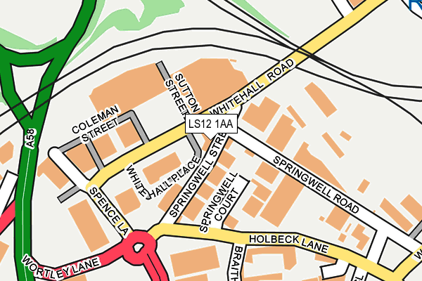
LS12 1AA lies on Whitehall Place in Leeds. LS12 1AA is located in the Beeston & Holbeck electoral ward, within the metropolitan district of Leeds and the English Parliamentary constituency of Leeds Central. The Sub Integrated Care Board (ICB) Location is NHS West Yorkshire ICB - 15F and the police force is West Yorkshire. This postcode has been in use since March 2004.


GetTheData
Source: OS OpenMap – Local (Ordnance Survey)
Source: OS VectorMap District (Ordnance Survey)
Licence: Open Government Licence (requires attribution)
| Easting | 428873 |
| Northing | 432869 |
| Latitude | 53.791340 |
| Longitude | -1.563205 |
GetTheData
Source: Open Postcode Geo
Licence: Open Government Licence
| Street | Whitehall Place |
| Town/City | Leeds |
| Country | England |
| Postcode District | LS12 |
➜ See where LS12 is on a map ➜ Where is Leeds? | |
GetTheData
Source: Land Registry Price Paid Data
Licence: Open Government Licence
Elevation or altitude of LS12 1AA as distance above sea level:
| Metres | Feet | |
|---|---|---|
| Elevation | 30m | 98ft |
Elevation is measured from the approximate centre of the postcode, to the nearest point on an OS contour line from OS Terrain 50, which has contour spacing of ten vertical metres.
➜ How high above sea level am I? Find the elevation of your current position using your device's GPS.
GetTheData
Source: Open Postcode Elevation
Licence: Open Government Licence
| Ward | Beeston & Holbeck |
| Constituency | Leeds Central |
GetTheData
Source: ONS Postcode Database
Licence: Open Government Licence
| Whitehall Rd Springwell Street (Whitehall Road) | Holbeck | 37m |
| Whitehall Rd Springwell Street (Whitehall Road) | Holbeck | 64m |
| Whitehall Rd Spence Lane (Whitehall Road) | Holbeck | 150m |
| Spence Lane Springwell Ln (Spence Lane) | Holbeck | 168m |
| Domestic Street Spence Ln (Domestic Street) | Holbeck | 225m |
| Leeds Station | 1.1km |
| Burley Park Station | 2.5km |
| Cottingley Station | 3.1km |
GetTheData
Source: NaPTAN
Licence: Open Government Licence
GetTheData
Source: ONS Postcode Database
Licence: Open Government Licence


➜ Get more ratings from the Food Standards Agency
GetTheData
Source: Food Standards Agency
Licence: FSA terms & conditions
| Last Collection | |||
|---|---|---|---|
| Location | Mon-Fri | Sat | Distance |
| Suttons Street | 18:30 | 11:00 | 43m |
| Whitehall Road | 18:30 | 46m | |
| Bridge Road/Holbeck Lane | 17:30 | 12:15 | 342m |
GetTheData
Source: Dracos
Licence: Creative Commons Attribution-ShareAlike
The below table lists the International Territorial Level (ITL) codes (formerly Nomenclature of Territorial Units for Statistics (NUTS) codes) and Local Administrative Units (LAU) codes for LS12 1AA:
| ITL 1 Code | Name |
|---|---|
| TLE | Yorkshire and The Humber |
| ITL 2 Code | Name |
| TLE4 | West Yorkshire |
| ITL 3 Code | Name |
| TLE42 | Leeds |
| LAU 1 Code | Name |
| E08000035 | Leeds |
GetTheData
Source: ONS Postcode Directory
Licence: Open Government Licence
The below table lists the Census Output Area (OA), Lower Layer Super Output Area (LSOA), and Middle Layer Super Output Area (MSOA) for LS12 1AA:
| Code | Name | |
|---|---|---|
| OA | E00169792 | |
| LSOA | E01033013 | Leeds 082E |
| MSOA | E02002411 | Leeds 082 |
GetTheData
Source: ONS Postcode Directory
Licence: Open Government Licence
| LS12 1AB | Whitehall Place | 11m |
| LS12 1AL | Springwell Court | 116m |
| LS11 9UN | Holbeck Lane | 126m |
| LS12 1AP | Whitehall Road | 153m |
| LS11 9RU | Sydenham Road | 330m |
| LS12 1DH | Gotts Road | 409m |
| LS12 1DJ | Gotts Road | 412m |
| LS12 1DL | Gotts Road | 413m |
| LS12 1DF | Gotts Road | 438m |
| LS12 1DW | Gotts Road | 441m |
GetTheData
Source: Open Postcode Geo; Land Registry Price Paid Data
Licence: Open Government Licence